Clear Sky Science · en
Five major earthquakes since the Late Classic Maya Period on the Motagua Fault in Guatemala
Why the Ground’s Past Matters for People Today
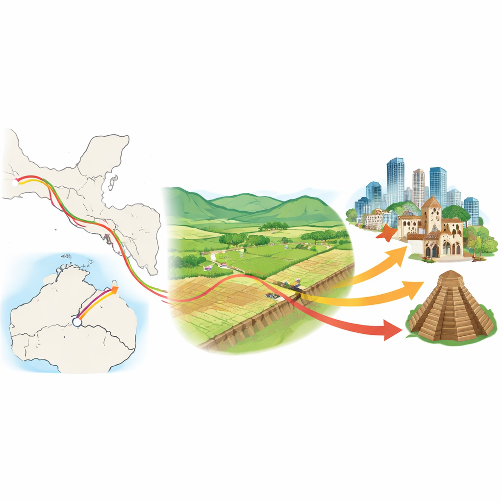
Along a quiet valley in Guatemala, the ground holds a hidden record of powerful earthquakes that have shaken cities, toppled temples, and changed where people live. This study uncovers that record along the Motagua Fault, a major break in Earth’s crust where two tectonic plates slide past each other. By digging into farm fields once cultivated by the ancient Maya and later by Colonial settlers, scientists show that at least five large earthquakes have ripped through this same spot over the past 1,300 years—information that helps explain past disasters and refine expectations for future ones.
A Dangerous Break in the Earth
Guatemala lies at a crossroads of three moving plates of Earth’s crust: the North American, Caribbean, and Cocos plates. Their motion is concentrated along big faults, including the Motagua Fault, which slipped catastrophically in 1976 and produced a magnitude 7.5 earthquake that killed more than 23,000 people. Yet, despite that tragedy, the long-term behavior of the Motagua Fault—how often it breaks, and how big those quakes can be—was poorly known. The researchers focused on a place called La Laguna Basin, about 30 kilometers from Guatemala City, where the 1976 rupture produced some of the largest measured ground shifts. The special bend of the fault there lifts one side and drops the other during earthquakes, building a small step in the land surface that can trap a remarkable geologic record.
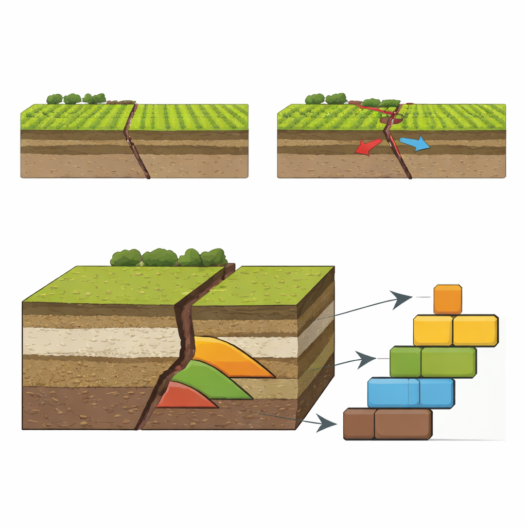
Reading Earthquake Scars in the Soil
At La Laguna, scientists dug a deep trench across the fault next to stone walls that were visibly offset by the 1976 quake. Each time the fault broke in the past, it created a fresh scarp; rain and erosion then washed soil and gravel from the higher side down into a wedge-shaped pile at the base of the step. In the trench walls, the team could see five such wedges stacked in sequence, each tied to a separate ground-rupturing earthquake. Because local people used the valley as farmland for centuries, these layers also contain charcoal, broken pottery, obsidian chips, and even freshwater snail shells. Radiocarbon dating of the charcoal, combined with careful mapping of the layers, allowed the team to estimate when each event occurred and how the surface shifted.
Linking Quakes to Ancient Cities and Colonial Towns
The dates from the trench line up strikingly with damage seen at nearby Maya and Colonial sites. Three earthquakes struck between roughly the 8th and 13th centuries. During this time, the Maya city of Quirigua shows evidence of cracked monuments, hastily added buttresses to support weakened temple walls, and later, sudden building collapses that buried victims in place—all signs of strong shaking. At the highland center of Mixco Viejo, major retaining walls and building phases around the 12th–13th centuries may also reflect rebuilding after large quakes. After this flurry of events, the fault appears to have gone quiet for about 600 years, until one or more strong earthquakes in the 1700s and then the devastating 1976 rupture. Historical accounts from the Colonial era suggest several 18th-century earthquakes could match the penultimate event seen in the trench, though sparse records make it hard to identify one specific year.
Uneven Rhythm of a Restless Fault
By combining trench data, archaeological evidence, and historical records, the researchers conclude that the Motagua Fault at La Laguna has produced at least five major surface-breaking earthquakes over the past ~1,300 years—in the 8th, 10th, 13th, 18th, and 20th centuries. On average, that works out to a repeat time of about 250–325 years, but the spacing between individual quakes is far from regular. Two recent events may be only about 200–225 years apart, while more than six centuries separate some earlier ones. Measurements of offset stone walls and modern satellite-based motion show that most of the plate movement here is released suddenly in earthquakes, not by slow, silent creep. The irregular timing may reflect how this fault shares strain with a nearby parallel fault, the Polochic, or how different sections of the boundary activate at different times.
What This Means for Life Along the Fault
For people living in Guatemala today, the study’s message is both sobering and empowering. The Motagua Fault is clearly capable of frequent, large earthquakes that directly affect nearby communities, and it does not follow a predictable schedule. Past societies along the fault adapted in different ways: Maya builders reinforced temples after damaging quakes; Colonial authorities eventually moved the capital city after repeated destruction; and, after 1976, Guatemala began to improve building practices to avoid deadly collapses. By revealing the fault’s true history, this work helps modern planners and residents better understand the level of risk and the importance of resilient construction and preparedness in a region where the ground has a long memory of sudden, violent motion.
Citation: Niemi, T.M., Grützner, C., Flores Beltetón, O. et al. Five major earthquakes since the Late Classic Maya Period on the Motagua Fault in Guatemala. Commun Earth Environ 7, 277 (2026). https://doi.org/10.1038/s43247-026-03271-y
Keywords: Motagua Fault, Guatemala earthquakes, Maya archaeology, plate boundaries, seismic hazard