Clear Sky Science · en
Impacts of industrial emissions on rock art at Murujuga, Western Australia
Ancient Stories Written in Stone
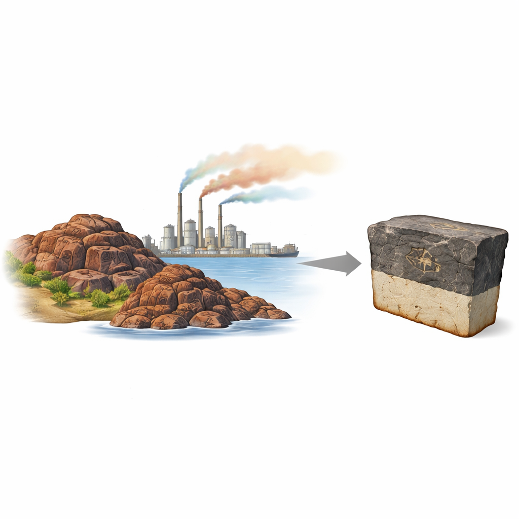
On the rocky islands of Murujuga, off the coast of Western Australia, more than a million stone carvings record 50,000 years of Indigenous knowledge, from changing seas to shifting animal life. Today, these petroglyphs share their home with gas plants, fertilizer factories and shipping lanes. For years, people have feared that fumes from this industry were creating acid rain that slowly eats away the dark outer skin of the rocks, and with it the carvings themselves. This study brings a fresh, data‑rich look at that fear and asks a simple question: is modern industry really dissolving Murujuga’s rock art right now?
Where Culture Meets Industry
Murujuga is now listed as a UNESCO World Heritage site for its cultural importance and deep time record of human life. The rock art is carved into several types of volcanic and igneous rock. Each image depends on a sharp contrast between a thin dark outer layer, called a patina, and a lighter weathered layer beneath it. As time passes, this contrast naturally softens. Because heavy industry arrived nearby in the 1960s, it has long been suspected that emissions of nitrogen and sulfur gases could make the rain more acidic, speeding up the loss of the dark patina and accelerating the fading of the art.
Testing the Acid Rain Story
To move beyond assumption, the authors and the Murujuga Rock Art Monitoring Project ran a large, multi‑year monitoring program across roughly 40 by 30 kilometers of islands and sea. They installed 30 air‑quality stations, took over 2000 electrochemical measurements on rock surfaces, and gathered rain, dust and gas data between 2022 and 2024. They measured key gases linked to acid formation, such as nitrogen dioxide, sulfur dioxide and ammonia, and mapped how these varied in space and time. They also recorded the acidity of rainfall, of dust settling from the air, and of thin films of water sitting directly on the rock surfaces.
What the Water and Rocks Revealed
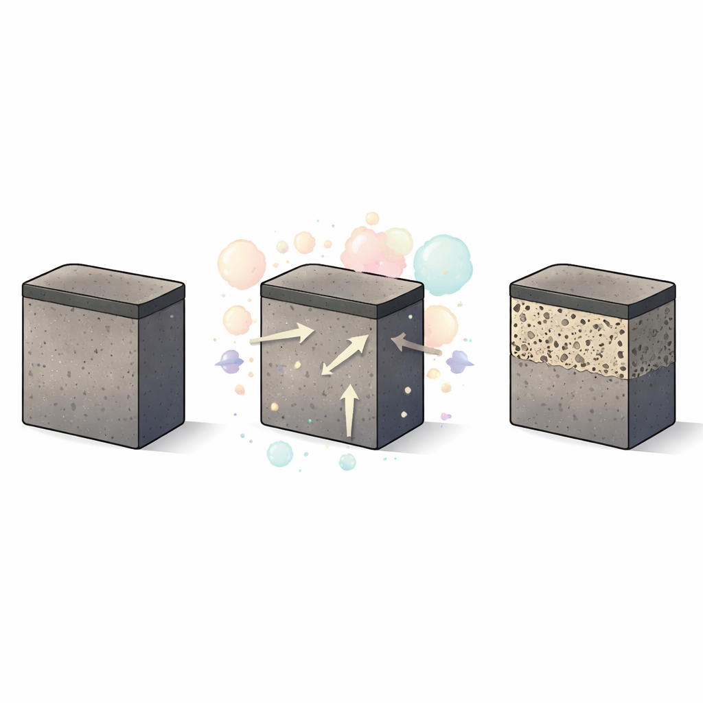
The results overturn some widely repeated claims. Rainwater at Murujuga was not acidic: its pH ranged from neutral to slightly alkaline, higher than what would be expected for pure rainwater in contact with ordinary air. Dust deposits on collection plates were also near neutral on average, with only a few slightly acidic readings, often linked to low dust levels rather than to strong gas pollution. Measurements on the rocks themselves did show mildly acidic surface films, typically with pH values between 4 and 6, but these patterns did not line up with where gas concentrations from industry were highest. Instead, rock surface acidity changed more from one field trip to another than from place to place, and it tended to be lower in the weeks after heavy rain, hinting that natural processes such as microbial activity on wet rock may be important.
A Hidden Layer Tells a Different Story
Because surface pH proved noisy and hard to interpret, the team looked deeper into the rocks. Using electron microscopes and image analysis, they quantified how porous the outer few millimetres of the most common rock type, granophyre, had become. This zone includes both the dark patina and the underlying “weathered rind,” the slightly altered outer shell of the rock. Here, a clear spatial pattern emerged: rocks closer to the industrial hub around Dampier and King Bay showed distinctly higher porosity than those on more distant islands. Statistical tests confirmed that this pattern was very unlikely to be due to chance. When the researchers compared these rock maps with records and models of sulfur dioxide emissions, they found that the porous zone today best matches areas that would have received the highest sulfur pollution in past decades, particularly when a local power station burned high‑sulfur fuel oil without strong controls.
Rethinking Risk and How We Watch for It
Laboratory “weathering chambers” that exposed fresh rock pieces to strong doses of industrial gases supported this picture. Minerals in the rocks did dissolve and release elements like calcium and sodium, confirming that such gases can, under the right conditions, open up pore spaces in the outer rock. Yet the acidity of surface water on these samples barely changed, reinforcing the field finding that surface pH is a poor simple gauge of damage. Taken together, the data suggest that much of the extra porosity seen near Murujuga’s industries is the legacy of earlier, heavier sulfur emissions rather than evidence of severe ongoing acid attack. The modern atmosphere over Murujuga appears less corrosive than once feared, though smaller ongoing effects cannot be ruled out.
Protecting the Carvings for the Future
For non‑specialists worried about the fate of Murujuga’s rock art, this work offers both reassurance and a new way to think about protection. The authors argue that the popular acid‑rain narrative, based purely on low surface pH, is too simple and often misleading. Instead, they propose using the outer weathered rind of the rock—its tiny pores and voids—as a more sensitive long‑term record of stress. By carefully sampling and imaging this layer over time and across different rock types, managers can better detect subtle changes, set safer emission limits, and act before visible damage appears. In short, the study suggests that while past industrial pollution has likely left a mark in the form of increased porosity, present‑day conditions are more moderate, and science‑based monitoring can help ensure that Murujuga’s stone stories endure for generations to come.
Citation: Evans, K.A., O’Leary, B., Tacchetto, T. et al. Impacts of industrial emissions on rock art at Murujuga, Western Australia. Sci Rep 16, 13805 (2026). https://doi.org/10.1038/s41598-026-44180-6
Keywords: Murujuga rock art, industrial emissions, acid rain, cultural heritage protection, rock weathering