Clear Sky Science · en
Global glacier-free topography reveals a large potential for future lakes in presently ice-covered terrain
A Hidden World Beneath the Ice
As glaciers shrink in a warming world, they are not just losing ice—they are uncovering an entirely new landscape. This study asks a deceptively simple question with big consequences: what does the ground beneath today’s glaciers actually look like, and what will appear once the ice is gone? The answers matter for future sea level, new lakes and rivers, natural hazards, and how people might use or protect these emerging lands.
Peering Under Glaciers Worldwide
Directly measuring the shape of the land under glaciers is extremely difficult; only about 2% of the world’s glaciers have such measurements. Earlier global estimates relied on simplified physics and limited data, leading to bedrock maps that sometimes showed unrealistic features like sharp “walls” between neighboring glaciers or unnaturally flat beds. In this work, the authors use a more advanced three-dimensional ice-flow model, run on powerful graphics processors and guided by machine learning, to reconstruct the hidden topography beneath more than 200,000 glaciers worldwide (excluding the large ice sheets in Greenland and Antarctica). They combine satellite-based elevation models, glacier outlines, ice flow speeds, changes in surface height, and millions of point measurements of ice thickness to produce a physically consistent map of glacier-free terrain, called TOPO-DE.
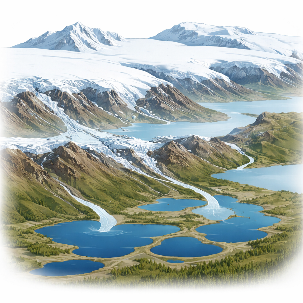
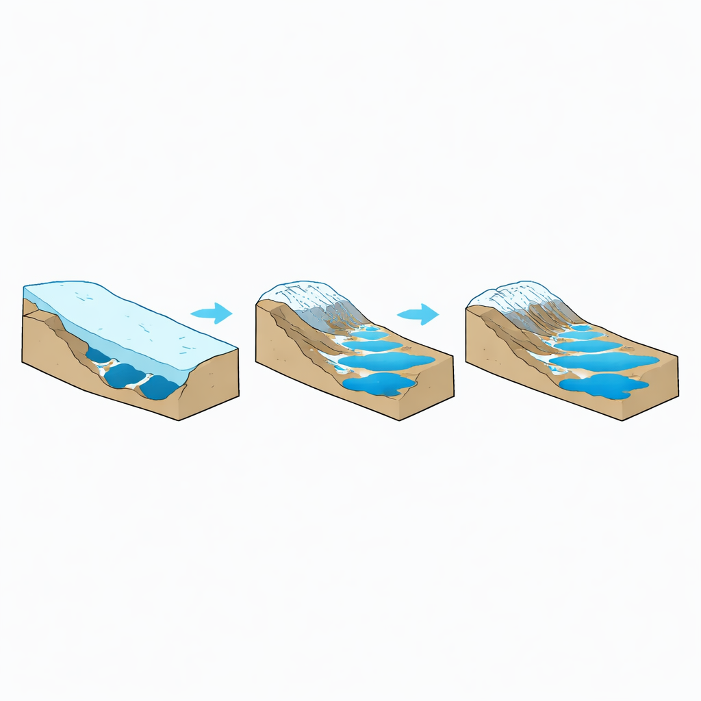
Revealing Valleys, Basins, and Future Lakes
The new maps show classic glacial landforms—U-shaped valleys, cirques, and deep overdeepened basins—much more clearly and realistically than previous products. Many marine-ending glaciers sit in deep troughs that extend below sea level, while mountain glaciers often overlie bowl-shaped depressions capable of holding substantial amounts of water once the ice disappears. Using a “fill the basins” approach, the team identifies where water would naturally collect if all glacier ice melted, assuming the bedrock itself does not change. They find about 56,000 potential new lakes larger than 0.05 square kilometers, covering roughly 40,000 square kilometers—around 6% of the land that would emerge from beneath today’s glaciers, three times the lake fraction on currently ice-free land.
Water Storage, Hazards, and Regional Differences
Together, these potential lakes could store about 3,138 cubic kilometers of water. Because some of that water would sit above sea level instead of flowing into the oceans, the lakes would reduce the effective sea-level rise from total glacier melt by about 7 millimeters, or 2%. The biggest volumes of future lake water are found in Alaska, the Southern Andes, and northern Arctic Canada, regions that already host many glacier-fed lakes today. Maritime climates like coastal Alaska, Iceland, New Zealand, and the Southern Andes favor strong glacier erosion and large moraines, producing especially deep and potentially large lakes. In contrast, steep mid-latitude mountain regions (such as parts of North America and Europe) host smaller lake volumes per unit of glacier area, even though they contain many glaciers.
Growing Risks from Mountain Lakes
One of the most pressing implications is hazard. In High Mountain Asia—home to densely populated downstream regions—many of the largest potential lakes are concentrated low on glacier tongues, where valleys are wide and moraines tall. These settings are prone to glacial lake outburst floods (GLOFs), sudden releases of water that can devastate communities and infrastructure downstream. The new maps suggest that, as glaciers retreat, large moraine- and bedrock-dammed lakes are likely to expand or newly form near glacier fronts in Asia, Alaska, New Zealand, and other steep mountain regions. While some of these lakes could provide water storage, hydropower, or tourism opportunities, they also increase exposure to floods and landslide-triggered waves as permafrost thaws and mountain slopes become less stable.
A Sharper Picture of Global Ice and Its Future
Beyond lakes, the study refines how much ice is actually stored in the world’s glaciers. The authors estimate a total glacier volume of about 149,000 cubic kilometers, equivalent to 308 millimeters of global sea-level rise if all that ice melted and flowed into the oceans. This global total agrees with recent studies but reveals important regional differences—some areas, such as High Mountain Asia and the Arctic, may hold less ice than earlier estimates suggested, while others hold more. Overall, the new glacier-bed map offers a powerful foundation for future research on sea-level rise, water resources, natural hazards, and the evolution of newly exposed landscapes as glaciers continue to retreat.
Citation: Frank, T., van Pelt, W.J.J., Rounce, D.R. et al. Global glacier-free topography reveals a large potential for future lakes in presently ice-covered terrain. Nat Commun 17, 3985 (2026). https://doi.org/10.1038/s41467-026-72548-9
Keywords: glacier retreat, subglacial topography, future glacial lakes, sea level rise, glacial lake outburst floods