Clear Sky Science · en
Global warming drives an increase in pre-monsoon tropical cyclone activity over the North Indian Ocean
Why earlier storms matter
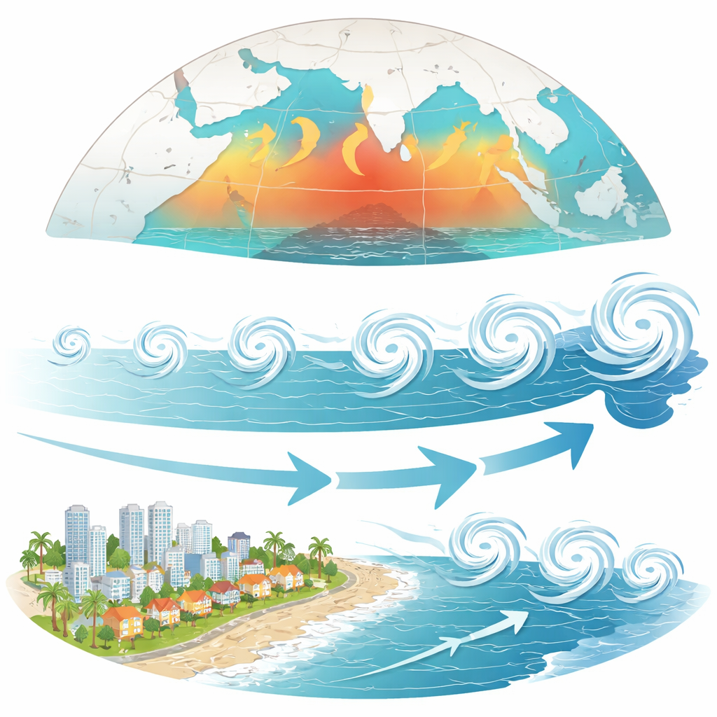
People living around the North Indian Ocean—from coastal India and Bangladesh to Myanmar and Oman—are no strangers to powerful tropical cyclones. What is changing, this study shows, is when the most dangerous storms are showing up. Rather than waiting for the traditional late-season peaks, more intense cyclone activity is now clustering in the pre-monsoon months of April to June, when communities may be less prepared and early warning systems are not yet on high alert.
Stronger early-season punch
The researchers examined four decades of storm records, focusing on the North Indian Ocean basin, which includes the Arabian Sea and the Bay of Bengal. Instead of simply counting storms, they used a metric called accumulated cyclone energy, which captures how many storms occur, how long they last, and how strong their winds are. Between 1981 and 2023, this combined measure of activity rose sharply during the pre-monsoon season, while changes in the more familiar post-monsoon season were weak and statistically uncertain. In other words, the total "punch" delivered by April–June storms has clearly grown, even though the overall number of storms each year remains modest.
Where the change is happening
The increase is not spread evenly across the region. The Arabian Sea, once known for comparatively fewer and weaker storms than the Bay of Bengal, now shows the fastest rise in early-season cyclone activity. Storm energy there has climbed by nearly 40 percent, compared with roughly 13 percent in the Bay of Bengal. Maps of storm tracks reveal that pre-monsoon cyclones are occurring more often and for longer durations over large swaths of the basin, especially between about 65°E and 75°E in the Arabian Sea and in central parts of the Bay of Bengal. Coastal areas within a few hundred kilometers of land—where people and infrastructure are concentrated—also show a clear upward trend in storm energy, confirming that these changes are not confined to open water.
Longer-lived storms, not necessarily stronger peaks
One might expect the rise in activity to be driven by ever more ferocious peak winds, but the analysis tells a subtler story. The main reason early-season cyclone energy has increased is that storms now tend to last longer and occur more frequently, rather than routinely hitting new records for maximum intensity. This pattern appears most clearly in the pre-monsoon months; in the post-monsoon season, regional increases and decreases in storm occurrence largely cancel out when averaged over the entire basin. The result is a growing burden of damaging wind, rain, and coastal flooding spread across more days, even if the absolute strongest storms have not dramatically changed.
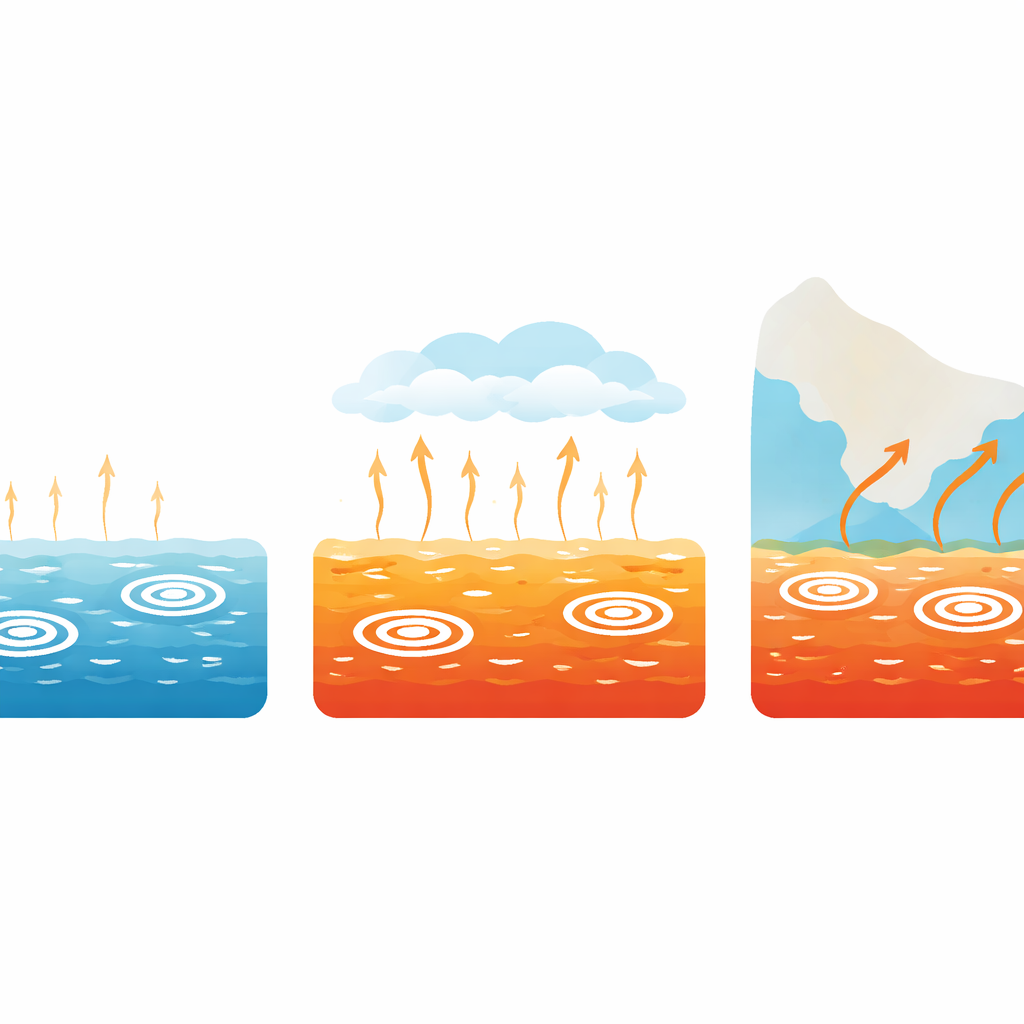
Warmer, moister air as the key fuel
To understand why early-season cyclones are becoming more common, the authors linked storm records with atmospheric data and climate-model experiments. They focused on how easily the environment can nurture new storms, using a composite index that blends sea surface warmth, humidity, and wind patterns. During April to June, this "storm-friendliness" index has risen significantly across much of the North Indian Ocean, mainly because the ocean surface is warmer and the air above is more humid. Climate simulations that separate different influences show that rising greenhouse gases are the dominant driver of these thermodynamic changes. Natural variations and the cooling effect of human-made aerosols play smaller or even opposing roles, and cannot explain the observed long-term increase.
What the future likely holds
Looking ahead, the same models project that sea surface temperatures and atmospheric humidity over the region will continue to climb under high-emission scenarios through the end of the century. That means the conditions that favor pre-monsoon tropical cyclones are expected to strengthen further, suggesting that the upward trend in early-season cyclone activity is unlikely to reverse on its own. For the tens of millions of people living along low-lying coasts fringing the North Indian Ocean, this shift implies that dangerous cyclones will not only remain a late-monsoon threat but will increasingly arrive earlier in the year, challenging existing planning, evacuation strategies, and infrastructure designed for a different climate baseline.
Take-home message for coastal communities
In plain terms, this study finds that global warming is loading the dice toward more active and longer-lasting tropical cyclones in the North Indian Ocean before the summer monsoon fully sets in. Because these early storms can be especially destructive—and often strike when people are not expecting them—regional disaster plans, early-warning systems, and long-term coastal development decisions will need to account for a cyclone season that effectively starts earlier and hits harder than it did a few decades ago.
Citation: Shan, K., Song, F., Lin, Y. et al. Global warming drives an increase in pre-monsoon tropical cyclone activity over the North Indian Ocean. Nat Commun 17, 2930 (2026). https://doi.org/10.1038/s41467-026-69818-x
Keywords: tropical cyclones, North Indian Ocean, pre-monsoon storms, climate change, sea surface warming