Clear Sky Science · en
Major fires in Indonesian Borneo are possible under all ENSO phases
Why Fires in Borneo Matter to Everyone
Each time vast peatlands in Indonesian Borneo burn, the impacts ripple far beyond the forest edge. Smoke from these long‑lasting fires has choked cities, damaged economies, released huge amounts of carbon into the air, and harmed the health of millions across Southeast Asia. Many people have learned to associate these catastrophic fire seasons with El Niño, the well‑known climate pattern that often brings drought to the region. This study asks a crucial question for communities, governments, and planners: are truly devastating fires only a threat when El Niño is strong, or can they strike in years when the climate looks relatively normal?
The Big Climate Patterns Behind Borneo’s Fires
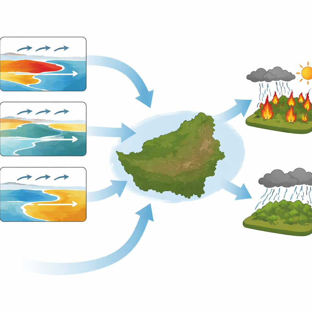
The researchers focus on how large‑scale swings in ocean temperatures and winds help set the stage for fires in Borneo’s peatlands. The main actor is the El Niño–Southern Oscillation (ENSO), which affects rainfall across the tropics by shifting rising and sinking air over the Pacific. In a typical El Niño, the air over the Maritime Continent, including Borneo, tends to sink, suppressing clouds and rain and drying out peat soils. Another player is the Indian Ocean Dipole (IOD), a pattern of warmer and cooler waters in the Indian Ocean that can also push rain toward or away from Indonesia. Both patterns help explain why notorious fire years like 1997 and 2015 were so severe, but the short historical record makes it hard to say how tightly fires are tied to these modes.
Using Many Simulated Seasons to Expand Our View
Because there are only a few decades of detailed observations, the team turned to a powerful seasonal prediction system run by the UK Met Office. This model produces dozens of slightly different versions of each year’s climate, all started from realistic conditions, creating 672 simulated fire seasons—far more than exist in the real‑world record. They estimated fire danger in each simulation using the Canadian Fire Weather Index, which responds strongly to rainfall deficits. After checking carefully that the model captures the observed link between ENSO and Borneo’s fire weather, and correcting for its tendency to be too dry overall, the authors used this expanded “what‑if” climate library to explore how often extreme fire conditions arise under different ocean states.
Fires Can Be Extreme Even Without a Classic El Niño
The simulations confirm that El Niño remains a potent amplifier of fire risk: using the highest fire danger value observed in 1997 as a benchmark, the chance of reaching or exceeding that level is roughly 2.7 times higher during El Niño conditions than on average. Yet the striking result is that similar or even worse fire weather sometimes appears in the model during years classified as neutral or even La Niña, when wetter conditions are usually expected. In these simulated seasons, rainfall over Borneo plunges despite the absence of a strong warming signal in the central Pacific. This means that, in principle, major fires could occur in years that would not have raised the usual red flags based on ENSO alone.
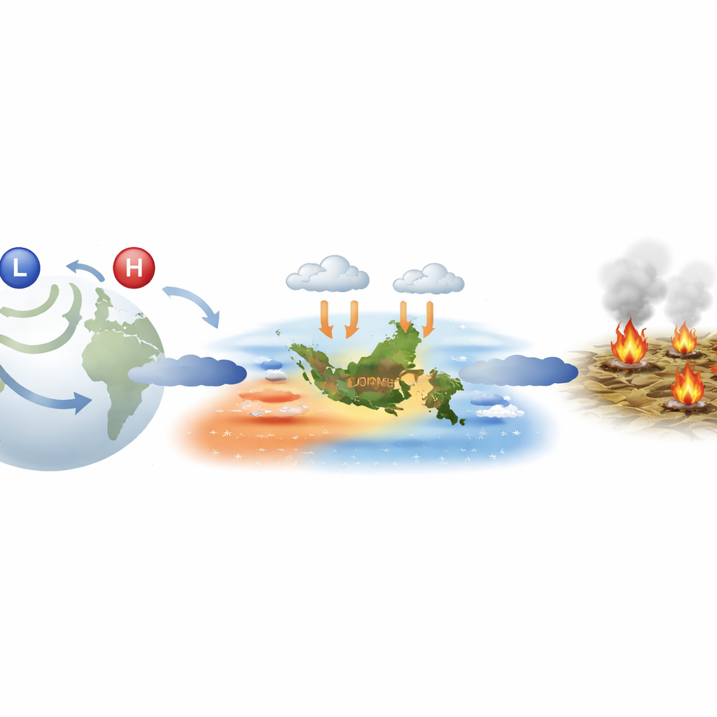
Hidden Atmospheric Pathways That Tip the Balance
To understand how such “surprise” dry years happen, the authors examined the global wind and pressure patterns in the simulations that produced high fire danger without El Niño. They found that the atmosphere sometimes rearranges itself in a way that mimics El Niño’s drying influence over Borneo even when the ocean pattern is weak. Waves of high and low pressure that ripple from the southern mid‑latitudes can bend toward the tropics and weaken the trade winds over the western Pacific, encouraging sinking air and reduced rainfall over the Maritime Continent. At the same time, a positive phase of the Indian Ocean Dipole often cools waters and reduces rain near Sumatra and Borneo. Together, these influences can decouple local rainfall from the expected ENSO signal, pushing Borneo into severe drought and high fire risk under climate backgrounds that would normally be considered relatively safe.
What This Means for Preparedness and Policy
For communities living with Borneo’s peatland fires, the study carries an important message: waiting for an El Niño warning before preparing for major fire seasons is not enough. While El Niño still greatly raises the odds of extreme fires, the analysis shows that dangerous fire weather is possible in any ENSO phase when other atmospheric patterns align unfavorably. This finding urges planners to treat severe fires as a recurring risk rather than a rare El Niño‑only problem, and to invest in long‑term measures that make peatlands and livelihoods more resilient every year—such as restoring wet conditions in drained peat, re‑establishing forests, and supporting land uses that do not rely on burning. Better short‑term forecasts remain valuable, but they must be paired with robust, year‑round strategies to face a climate system that can sometimes break its own rules.
Citation: Lam, T., Catto, J.L., Kay, G. et al. Major fires in Indonesian Borneo are possible under all ENSO phases. npj Nat. Hazards 3, 46 (2026). https://doi.org/10.1038/s44304-026-00209-4
Keywords: Borneo peatland fires, El Niño and fire risk, Indonesian haze, Indian Ocean Dipole, climate teleconnections