Clear Sky Science · en
Significant greenhouse gas emissions from flooded drylands in Kati Thanda Lake Eyre basin in Australia
When Dry Lands Suddenly Breathe Out
Much of the Earth’s land is dry for most of the year, yet these regions can briefly turn into enormous shallow lakes and wetlands after rare, intense rains. This study explores what happens to the air we breathe when one of the world’s great desert basins in central Australia suddenly floods. The work shows that these short-lived “inland seas” can release surprisingly large bursts of greenhouse gases, with implications for how we understand and predict climate change.
A Giant Inland Basin Wakes Up
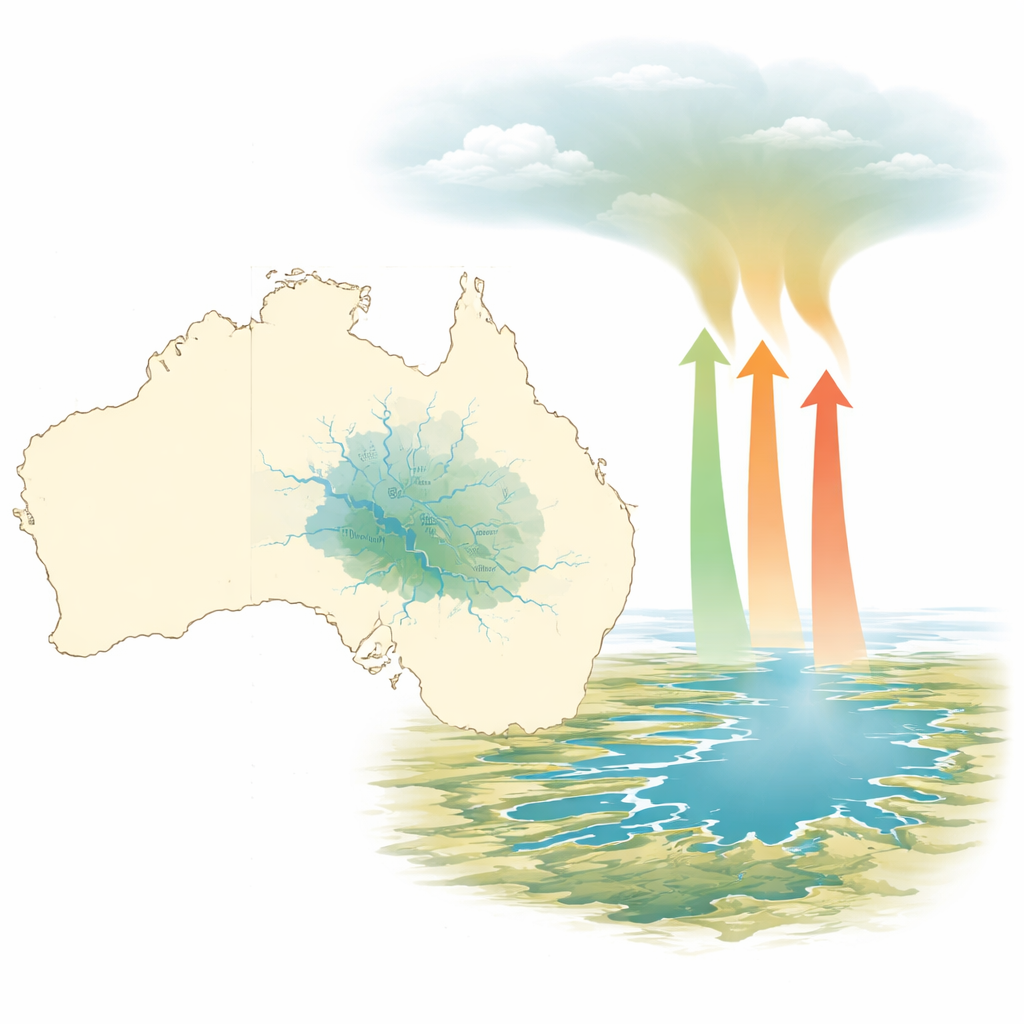
The Kati Thanda–Lake Eyre basin in central Australia is one of the world’s largest closed drainage systems, covering about one seventh of the continent. Most of the time it is a landscape of dry riverbeds, dusty floodplains, and a vast salt lake. In early 2019, two major rain events in the basin’s northern catchments sent slow-moving floodwaters thousands of kilometers down broad, flat river systems. For months, normally dry floodplains and lake beds were covered with shallow water across an area that at times exceeded 30,000 square kilometers. This rare transformation provided an opportunity to measure how much carbon dioxide, methane, and nitrous oxide moved from the newly flooded surface into the atmosphere.
Chasing Floodwaters by Air
Because the basin is remote and roads become impassable during floods, the researchers used a helicopter and vehicles to collect water samples across roughly 2,200 kilometers of rivers, floodwaters, floodplains, and lakes. They measured dissolved gases in the water and basic conditions such as temperature, salinity, oxygen, and flow. From these data, they calculated how quickly gases were moving from water to air over different kinds of flooded landscapes, such as fast-flowing channels, slow floodplain waters, and the open surface of Kati Thanda–Lake Eyre itself. Satellite images from NASA were then used to track how much area was wet or flooded each day through 2019, allowing the team to scale up the point measurements to the entire basin over the full wet period.
Hidden Chemistry Under Shallow Water
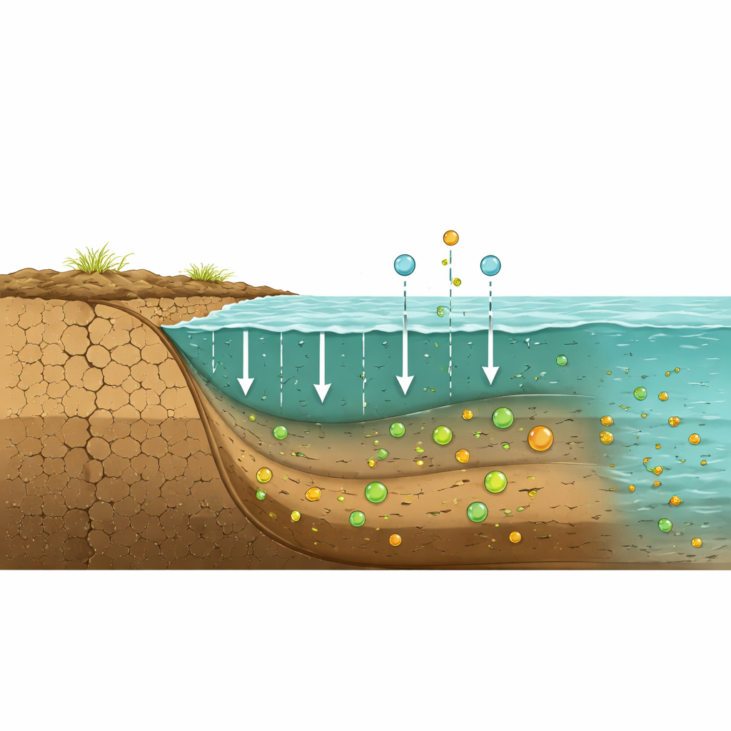
When long-dry soils are suddenly soaked, the organic material that has built up during drought begins to break down rapidly. Microbes feast on this material, consuming oxygen and releasing carbon dioxide. In waterlogged layers where oxygen cannot easily penetrate, different microbes generate methane and transform nitrogen in ways that can either release or consume nitrous oxide. In the Lake Eyre basin floods, rivers and fresh floodwaters were rich in carbon dioxide and methane, while the broad floodplains combined large surface area with strong gas release. The salty main lake, by contrast, produced very little methane, probably because its extreme salt levels suppress the microbes that normally generate this gas.
Big Bursts from a Seemingly Empty Place
By combining their field measurements with satellite-based estimates of flooded area, the researchers calculated that during the 2019 wet period the basin likely released on the order of 127 teragrams of carbon dioxide and smaller but still important amounts of methane, while actually drawing in some nitrous oxide from the air. Expressed as climate impact over a 20-year period, the net effect of these gases was roughly 130 teragrams of carbon dioxide equivalents. For perspective, the carbon dioxide emitted from this single, months-long flooding episode amounted to nearly three percent of typical yearly emissions from all of the world’s inland rivers, and about a third of Australia’s annual fossil-fuel carbon emissions. On the wettest days, the flooded landscape was releasing hundreds of times more carbon to the air than the rivers were carrying downstream in dissolved form.
Why These Rare Floods Matter for Climate
Although such large floods are infrequent, they may play an outsized role in year-to-year swings of the global carbon budget. Drylands cover nearly half the planet and are expected to experience longer dry spells punctuated by more intense rainfall as the climate warms. The Lake Eyre results suggest that when these regions flood, they can become powerful but short-lived sources of greenhouse gases that are not currently captured well in climate models or monitoring networks. Understanding how often such floods occur, how long the land stays wet, and how vegetation responds afterward will be crucial for deciding whether these bursts simply balance out over time or add a significant extra push to global warming.
Citation: Eyre, B.D., Rosentreter, J.A. & Erler, D.V. Significant greenhouse gas emissions from flooded drylands in Kati Thanda Lake Eyre basin in Australia. Sci Rep 16, 9884 (2026). https://doi.org/10.1038/s41598-026-35915-6
Keywords: dryland flooding, greenhouse gas pulses, Lake Eyre basin, floodplain emissions, carbon cycle variability