Clear Sky Science · en
Hard rocks and deep wetlands beneath Thwaites Glacier in Antarctica
Hidden Landscape Beneath a Giant Glacier
Thwaites Glacier in West Antarctica has been nicknamed the “Doomsday Glacier” because changes there could raise global sea levels by many tens of centimeters over coming centuries. Yet, until recently, scientists had only a fuzzy picture of what lies beneath its two kilometers of ice. This study used sensitive seismic surveys—essentially controlled echoes in the ice—to create a detailed map of the glacier’s hidden underworld. The findings reveal a rugged mix of hard rock ridges, deep sediment-filled basins, and extensive wet zones and subglacial wetlands that all work together to control how fast the glacier can retreat toward the interior of Antarctica.
Why the Ground Under the Ice Matters
Thwaites Glacier is already one of Antarctica’s largest contributors to sea-level rise, and it sits on bedrock that slopes downward inland. That geometry makes it particularly vulnerable: once the “grounding line,” where the glacier lifts off the bed and starts to float, retreats inland, the ice can become unstable and flow more quickly into the ocean. How fast this happens depends not just on warm ocean water melting the glacier’s front, but also on the character of the ground beneath the ice. A hard, rough bed can act like brakes, while soft, waterlogged sediments can turn the base of the glacier into a slippery slide. Until now, models have had to guess many of these properties, leading to wide ranges in projections of future sea-level rise.
Listening for the Shape and Strength of the Bed
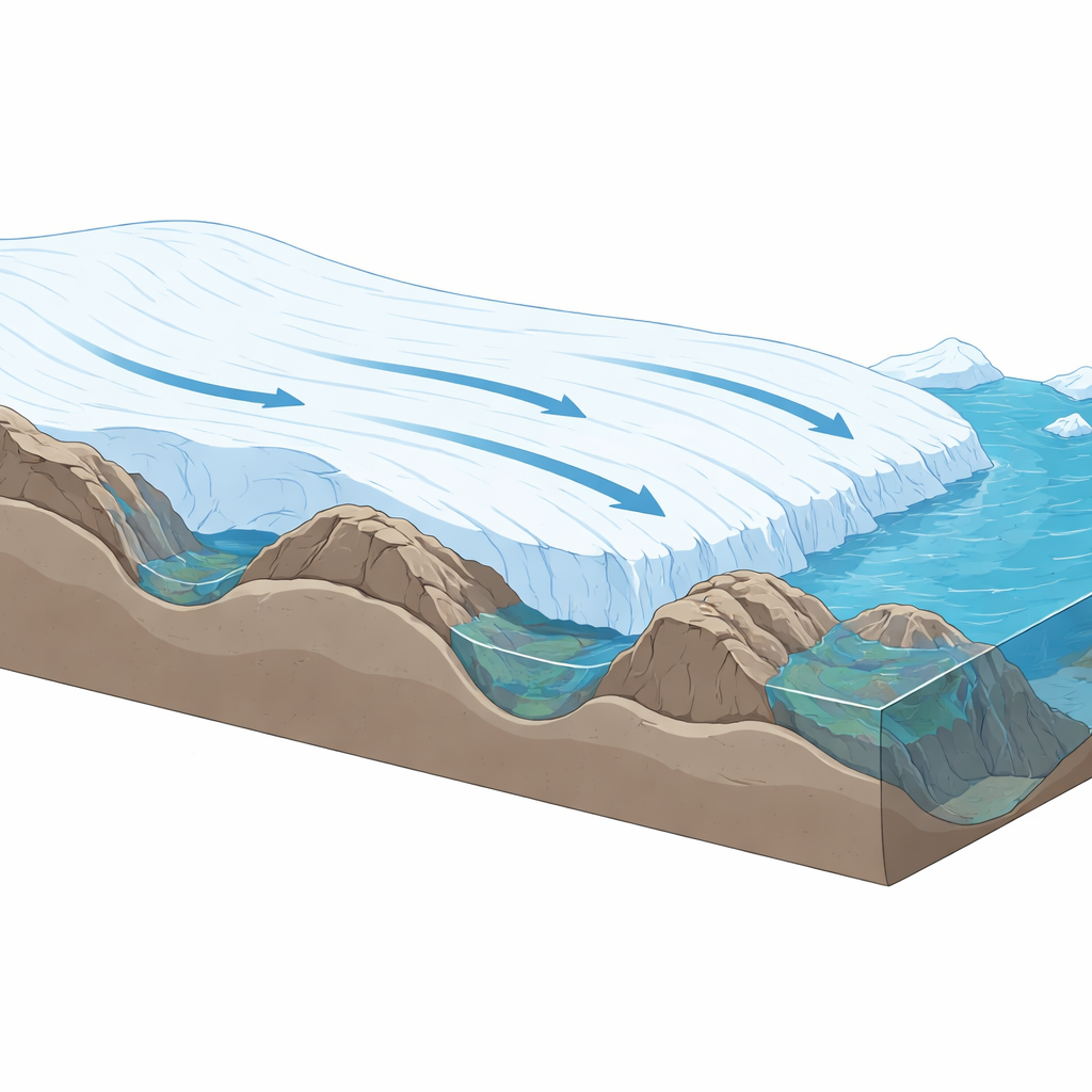
The research team drove more than 340 kilometers across Thwaites Glacier towing a specialized seismic vibrator and a “snowstreamer” of sensors. By sending controlled vibrations into the ice and recording the returning echoes, they reconstructed a high-resolution picture of the bed’s shape and the materials that make it up. The along-flow profile, running from near the grounding line hundreds of kilometers inland, shows alternating zones of smooth, gently sloping terrain and rugged high ridges with steep faces pointing upstream. A second profile cutting across the glacier reveals how these features and materials vary from the fast-flowing central trunk out to the slower-moving margins.
Ridges, Rock Bumps, and Wet Basins
The seismic data show that the bed of Thwaites is anything but uniform. Large rocky ridges, such as Lower and Upper Thwaites Ridge, rise hundreds of meters above their surroundings and present steep upstream faces. These act like buried sills that resist fast ice flow. On their downstream sides, the team found smoother “tails” made of consolidated sediments overlain by softer, deformable layers—classic “crag-and-tail” landforms carved and built by flowing ice. Between the ridges lie deep basins, some up to several hundred meters thick, filled with sediments that range from firm to highly porous. In many depressions, the seismic reflections indicate the presence of free water or water-rich sediment, forming pockets and layers of wet ground that can reduce friction at the base of the ice.
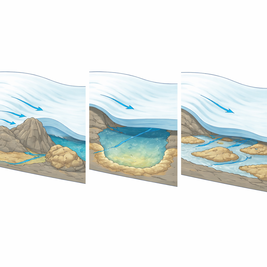
A Deep Wetland Beneath the Ice
One of the most striking discoveries is an active subglacial lake, known as Thw124, beneath the fast-flowing trunk of the glacier. From space, satellites show this area slowly rising and falling by several meters as water drains and refills. The seismic profiles reveal that this lake is not simply a flat pool of water, but tens to more than a hundred meters of extremely porous, water-saturated sediment resting on a firmer base. These soft, wet deposits are concentrated downstream of bedrock highs, echoing the geometry of crag-and-tail features but with a much “mushier” composition. Even after drainage events, much of the water remains trapped in the sediment, so the base behaves more like a persistent wetland or aquifer than a simple on–off lake. Elsewhere, under the eastern edge of the glacier, the bed is mostly hard and consolidated, with only scattered pockets of softer, wetter material.
Implications for Future Sea-Level Rise
For non-specialists, the key message is that the fate of Thwaites Glacier depends strongly on details of the unseen ground beneath it. Instead of a simple hard or soft base, the glacier rests on a patchwork of rock ridges, sedimentary basins, and water-rich wetlands. Hard, steep ridges act as brakes that can temporarily slow the inland retreat of the grounding line, while deep, wet basins and water-saturated sediments can allow ice to slide more easily and thin farther upstream. Current computer models generally smooth over this complexity, which means they may underestimate how much these hidden features can either resist or accelerate retreat. By providing one of the most detailed looks yet at an Antarctic glacier’s underworld, this study gives modelers the information they need to better predict how much and how quickly Thwaites Glacier could add to global sea levels.
Citation: Zeising, O., Eisen, O., Hofstede, C. et al. Hard rocks and deep wetlands beneath Thwaites Glacier in Antarctica. Commun Earth Environ 7, 366 (2026). https://doi.org/10.1038/s43247-026-03502-2
Keywords: Thwaites Glacier, subglacial hydrology, Antarctic ice sheet, sea-level rise, vibroseismic imaging