Clear Sky Science · en
Physical understanding of the extreme global temperature jump in 2023
Why 2023’s heat spike matters
In late summer and early fall of 2023, global surface temperatures shot up far beyond anything recorded before, alarming scientists and the public alike. This study asks a simple question with far-reaching consequences: was this jump a sign that global warming suddenly sped up, or the result of a rare configuration of natural climate patterns stacked on top of human-caused warming?
A record-setting jump in global warmth
The authors show that the biggest part of the 2023 temperature surge came from the world’s oceans, especially the vast Indo-Pacific basin. Comparing August to October 2023 with the same months in 2022, they find a record year-to-year rise in global marine surface air temperature. About two thirds of this ocean jump was linked to waters in the Indo-Pacific, with extra contributions from the unusually warm North Atlantic and extensive land regions in the tropics and northern midlatitudes. The overall magnitude and timing of the spike, however, stand out from past strong El Niño years, suggesting something different was at play.
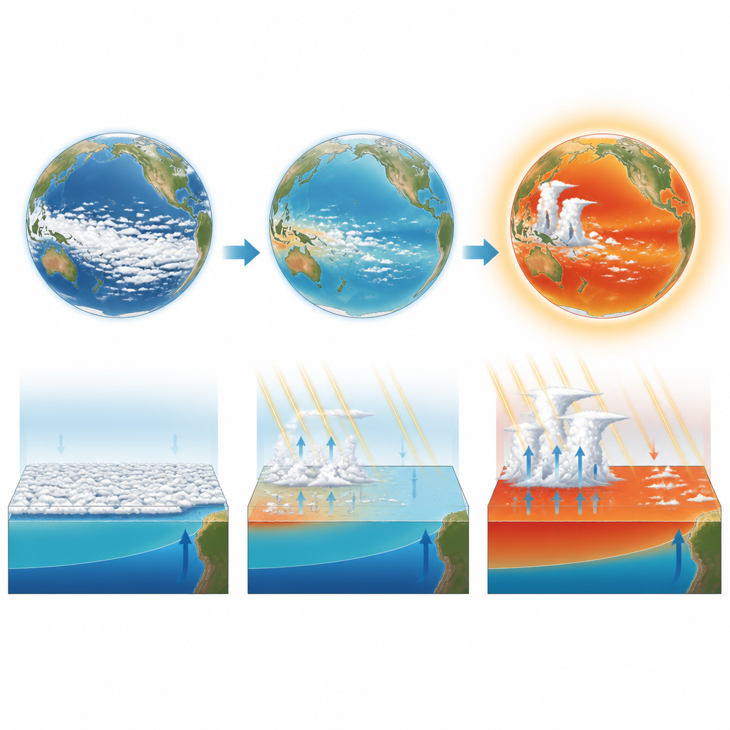
A new El Niño on top of lingering La Niña
El Niño and La Niña describe swings in Pacific Ocean temperatures and winds that ripple through the global climate. Typically, global temperatures peak some months after El Niño has fully developed. In 2023, a moderate-to-strong El Niño grew out of a rare “triple-dip” La Niña that had cooled the eastern Pacific for several years. This set the stage for an unusually sharp shift: cold surface waters and thick decks of low clouds in 2022 flipped to much warmer seas in 2023, especially in regions where air normally sinks. No comparable Indo-Pacific temperature jump is seen in previous strong El Niño events dating back to 1979.
Clouds, sunlight, and an energy surge
Because low clouds act like a bright mirror for sunlight, changes in cloud cover can strongly affect how much energy the Earth system absorbs. The rapid warming of sea surface temperatures in normally dry, subsiding regions over the eastern and central Pacific reduced the stability of the lower atmosphere, thinning and breaking up low cloud layers. As these reflective clouds shrank, more sunlight reached the ocean surface. The authors find that the Indo-Pacific region experienced one of the largest increases in net incoming energy at the top of the atmosphere since satellite records began, closely overlapping the zones of strongest warming. This energy gain, together with a very low global reflectivity in 2023, helped charge up the upper ocean and primed the atmosphere for rapid warming.
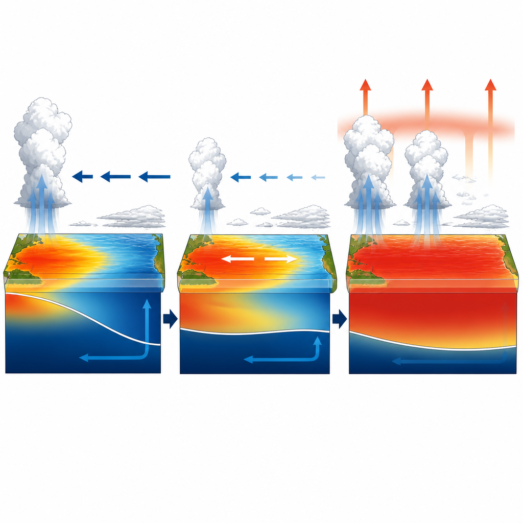
Unusual tropical rains and early atmospheric heating
Rainfall patterns over warm tropical seas control where heat is released into the atmosphere. In a “canonical” El Niño, rain tends to decrease over the western Pacific warm pool and increase over cooler central and eastern regions later in the year. In 2023, that pattern was muted and shifted. Sea surface temperatures over the warm pool stayed higher than in typical El Niño events, and rainfall there actually increased instead of shrinking. At the same time, eastern Pacific waters warmed but seasonal cooling limited deep storm formation. The study uses an index that weights sea temperatures by rainfall and shows that this odd mix allowed the tropical troposphere to heat up earlier than usual, already in late summer, rather than waiting until winter.
From tropics to globe: why the spike was so large
Once the tropical free atmosphere warms, large-scale wave patterns spread that heat toward higher latitudes, lifting global surface air temperature. The authors find a tight statistical link between tropical mid-level temperatures and global surface warmth, and 2023 sits near the upper edge of that relationship. They also identify extra boosts from the record-warm tropical North Atlantic and from a background pattern of sea surface temperatures that resembles La Niña on longer time scales. Many of these slow variations and cloud responses are poorly captured in current climate models, which may explain why simulations struggle to reproduce an event as extreme as the 2023 jump.
What this means for our future
The study concludes that the extraordinary 2023 heat spike arose not from a sudden new rate of human-driven warming, but from a rare alignment of natural processes acting on top of the long-term trend. A preceding multi-year La Niña, decades of heat buildup in the western Pacific, record-low low cloud cover over the eastern Pacific, an unusual El Niño pattern, and a super-warm Atlantic all combined in the same season. Each factor has been seen before, but their timing in 2023 was exceptional. This work suggests that as the planet continues to warm, similar alignments of ocean states and clouds can temporarily push global temperatures far above the underlying average, offering an early preview of conditions expected later this century.
Citation: Mex, J., Cassou, C., Jézéquel, A. et al. Physical understanding of the extreme global temperature jump in 2023. Commun Earth Environ 7, 406 (2026). https://doi.org/10.1038/s43247-026-03382-6
Keywords: 2023 heat spike, El Niño, Indo-Pacific warming, cloud feedbacks, global surface temperature