Clear Sky Science · en
A unified deep learning framework integrating OpenStreetMap for multi-domain urban planning tasks
Smarter Maps for Growing Cities
As cities swell with people and cars, planners struggle to keep up: roads clog, green spaces vanish, and air grows dirty. This study shows how freely available online maps, satellite images from space, and modern artificial intelligence can be woven together to give city officials a constantly updated “X‑ray” of their streets, buildings, traffic, and air. Focusing on the fast-growing Russian city of Krasnodar, the authors build a digital framework that turns raw geo-data into practical guidance for where to build, how to move, and how to breathe easier.
Why Ordinary Maps Are No Longer Enough
Traditional planning tools rely on official maps and surveys that are costly to produce and quickly become outdated. At the same time, platforms like OpenStreetMap, where volunteers trace roads and buildings, offer free and rich detail—but with uneven quality and gaps, especially in less busy districts. The authors argue that neither source alone can fully capture the complexity of a modern city. Their solution is to fuse volunteer-drawn maps with satellite pictures, population statistics, and air and weather readings, then let deep learning algorithms discover patterns that humans would struggle to spot at scale.
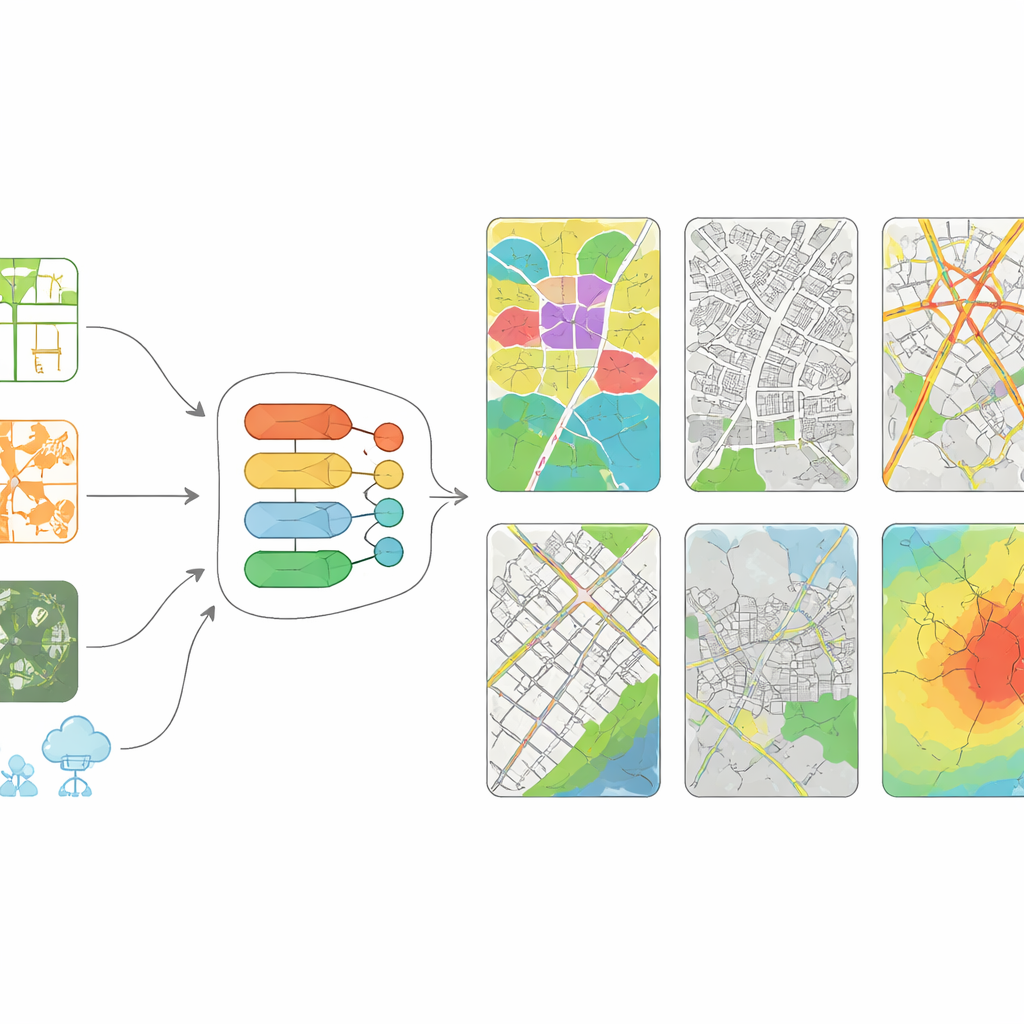
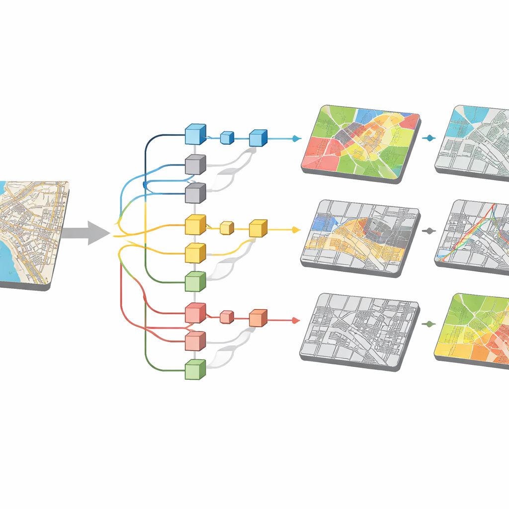
From Raw City Data to a Digital Twin
The framework works as a four-step pipeline. First, it gathers many layers of information on Krasnodar: OpenStreetMap road and building outlines, Sentinel‑2 satellite images, census-style population grids, and year-long traffic and air-quality measurements. Second, it carefully cleans and aligns these data so that every pixel and street segment lines up on the same grid. Third, it trains several specialized neural networks, each tuned to a different job: one to mark land-use types such as homes or parks, one to trace building footprints, one to predict how many cars pass sensors at different times, and one to forecast fine-particle pollution. Finally, it stitches the outputs together into a set of urban indicators that describe the city’s structure, movement, and environmental conditions in a unified way.
How Well the Digital City Learns
To see whether this digital twin can be trusted, the team compares its results with high‑quality reference data. For mapping land use, their model correctly classifies areas about 92% of the time, and it is particularly strong at finding green spaces. The building‑tracing network overlaps with true building shapes almost 89% of the time, a level that matches or slightly outperforms leading studies using similar imagery. For traffic, the system predicts hourly car counts at city sensors with only a few vehicles’ difference on average, and it estimates short‑term air pollution with errors of just a couple of micrograms per cubic meter. These scores sit within, and often at the upper end of, published benchmarks, suggesting that combining several data sources genuinely sharpens the view of the city.
What the Framework Reveals on the Ground
Because all tasks run inside the same framework, their outputs reinforce one another. Detailed building maps help clarify where people actually live and work, which in turn refines traffic and pollution patterns. Land‑use maps highlight districts short on parks, while traffic forecasts pinpoint recurring rush‑hour choke points that might benefit from smarter signals or better public transit. Air‑quality predictions show when and where tiny soot particles are likely to spike, giving officials a basis for targeting emission controls. Although the approach depends on computing power and still inherits some blind spots from patchy volunteer mapping and sparse sensors, its modular design means other cities with basic map and satellite coverage can adopt it.
What This Means for Future Cities
In plain terms, the study demonstrates that blending crowd-sourced maps, satellite views, and sensor readings with deep learning can turn a patchy picture of a city into a coherent, high‑resolution guide for everyday decisions. Rather than treating land use, traffic, and air quality as separate problems, this framework links them in a single, adaptable system. For residents, that could translate into less time in traffic, more green spaces, and cleaner air. For planners and policymakers, it offers a scalable recipe for building smart, sustainable cities without relying solely on expensive proprietary data.
Citation: Chen, Y., Afandi, W.S., Gura, D. et al. A unified deep learning framework integrating OpenStreetMap for multi-domain urban planning tasks. Sci Rep 16, 10870 (2026). https://doi.org/10.1038/s41598-026-45927-x
Keywords: urban planning, OpenStreetMap, deep learning, traffic prediction, air quality