Clear Sky Science · en
Hydrostatic sea-level rise inundation impacts on ahu and harbors of Rapa Nui (Easter Island)
Why this island’s story matters
Rapa Nui, better known as Easter Island, is famous for its towering stone statues and the platforms that hold them, as well as the small harbors that keep the island supplied. This study shows how rising seas threaten both the island’s ancient monuments and its modern lifeline. By tracing when and how seawater will reach key sites, the researchers reveal what is at stake for local culture, tourism, and daily life—and why choices made in the coming decades will shape the island’s future.

An island of ancestors and ocean swells
Rapa Nui is a remote volcanic island in the southeastern Pacific, far from any continent and ringed mostly by rocky cliffs and narrow shores. Along this rugged coast stand more than 200 ahu—stone platforms, some topped by the famous moai statues that honor ancestors and anchor community identity. Nearby, six small harbors shelter fishing boats and receive cargo and visitors. Tourism built around this heritage supports most of the island’s economy, while ships bring in nearly all food, building materials, and fuel. Yet the same ocean that has long sustained Rapa Nui is becoming more hazardous as sea level rises and powerful swells and storm-driven surges push water higher onto the land.
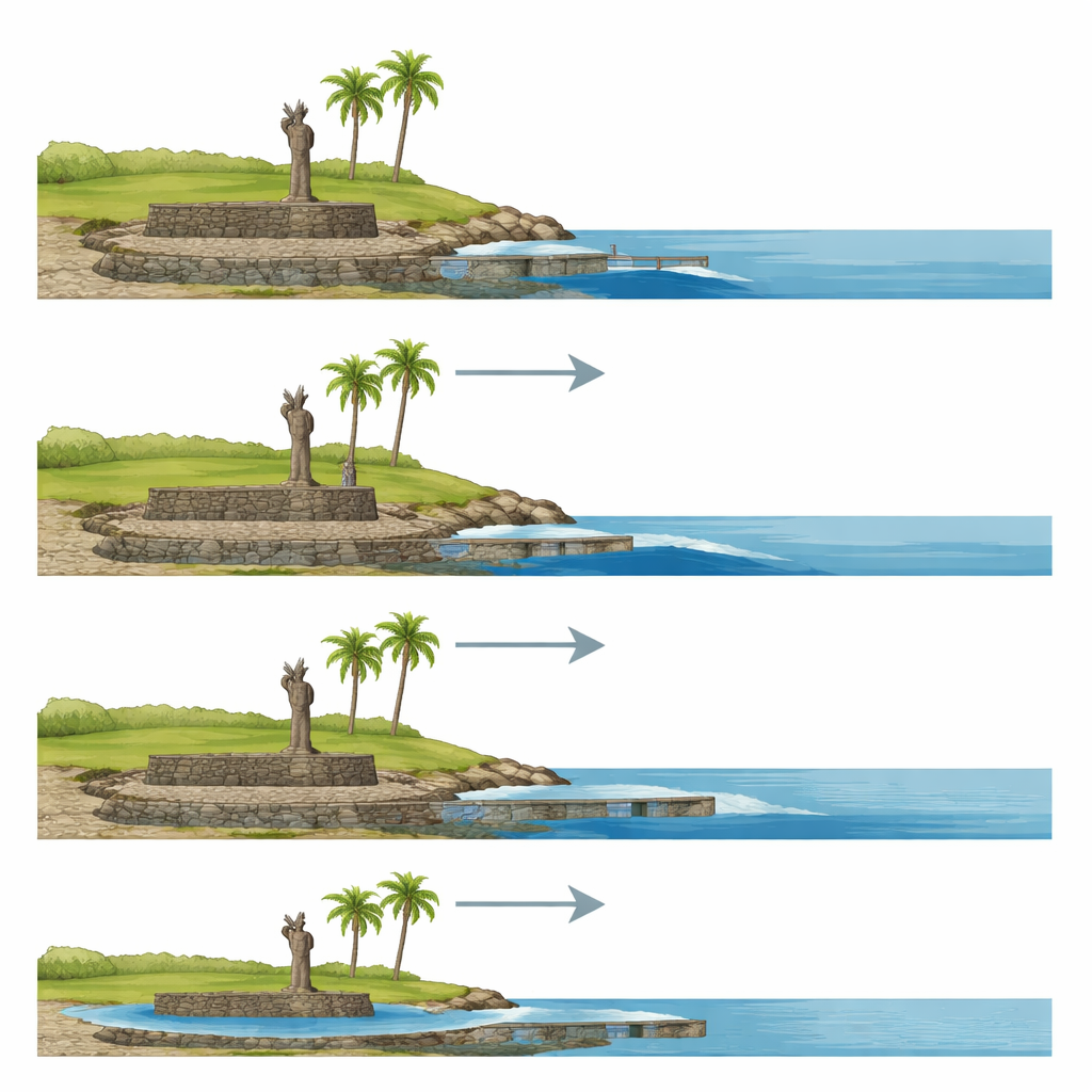
Measuring today’s water to glimpse tomorrow
To understand future flooding, the team began with careful measurements of present-day sea levels from a tide gauge at the main harbor. They defined two reference levels: the typical high-tide line, called mean higher high water, and a much rarer extreme level that has only about a one-in-one-hundred chance of occurring in any given year. Using a detailed elevation map built from laser surveys and on-the-ground measurements of ahu and harbor docks, they then simulated how water would spread across the coast as the ocean surface is raised step by step, up to almost four meters above today’s level. Their method assumes “bathtub” flooding—water filling low areas based on height—so it is designed to provide conservative, minimum estimates of exposure.
Ancient platforms in the path of the sea
The results show that Rapa Nui’s coastal heritage is already feeling the effects of the rising ocean. Four ahu sit low enough that present-day water levels can reach them, matching recent observations of damaged retaining walls and sinkholes after strong swell events. As sea level climbs, more sites are drawn into the danger zone: under a high-emissions pathway, about a dozen ahu could be regularly touched by high water by around 2080, and 33 are affected in the highest scenario studied. Most flooding would come from waves and high tides overtopping the shore, but at two important sites the model also shows water emerging from below as the groundwater table rises inland, hinting at a quieter but still serious pathway of damage that may call for different protective measures.
Harbors under mounting pressure
The island’s harbors prove even more vulnerable than the ahu. Under everyday high tides, many docks begin to flood once sea level rises by roughly half a meter to a meter, and all but one are fully submerged by about 1.2 meters of rise. When the researchers look at the rarer extreme events, some harbors already experience partial or total flooding today. With only 30 centimeters of additional rise, every harbor is projected to see at least one dock underwater during these extremes. Comparing the model with photographs from recent storms shows that real events can push water farther inland than the simple flooding model predicts, because storm surges, harbor sloshing, and waves stack on top of higher tides. That means the timelines produced here are likely optimistic: serious disruption to marine access could arrive sooner than the numbers alone suggest.
Choosing how to live with a changing shore
Faced with these projections, the authors argue that Rapa Nui cannot rely on one single solution. They outline a mix of options—raising and strengthening harbor structures, building subtle offshore or coastal barriers to blunt wave energy near vulnerable ahu, reinforcing foundations, or in some cases allowing partial flooding or even relocating elements. Any intervention, they stress, must be guided by the Rapanui community, whose authority over how their sacred sites evolve has often been undermined by outside narratives. By planning ahead and treating heritage as part of a living, adaptable landscape rather than a frozen museum piece, the island can both protect its identity and keep its economy functioning as the seas continue their inexorable rise.
Citation: Paoa, N., Fletcher, C.H., Barbee, M. et al. Hydrostatic sea-level rise inundation impacts on ahu and harbors of Rapa Nui (Easter Island). Sci Rep 16, 14509 (2026). https://doi.org/10.1038/s41598-026-45195-9
Keywords: sea-level rise, Easter Island, cultural heritage, coastal flooding, climate adaptation