Clear Sky Science · en
Integrated 3D static modelling to assess hydrocarbon potential of the fluvial-alluvial sandstones of Nukhul Formation, October oil field, Gulf of Suez, Egypt
Hidden Oil in a Famous Field
The October Oil Field in Egypt’s Gulf of Suez has powered the country for decades, but many experts believed one of its key rock layers, the Nukhul Formation, was largely drained. This study shows that assumption was wrong. By rebuilding a highly detailed three-dimensional picture of the rocks and faults deep underground, the authors reveal overlooked pockets of oil and new places to drill, offering a blueprint for squeezing more energy from mature fields worldwide.
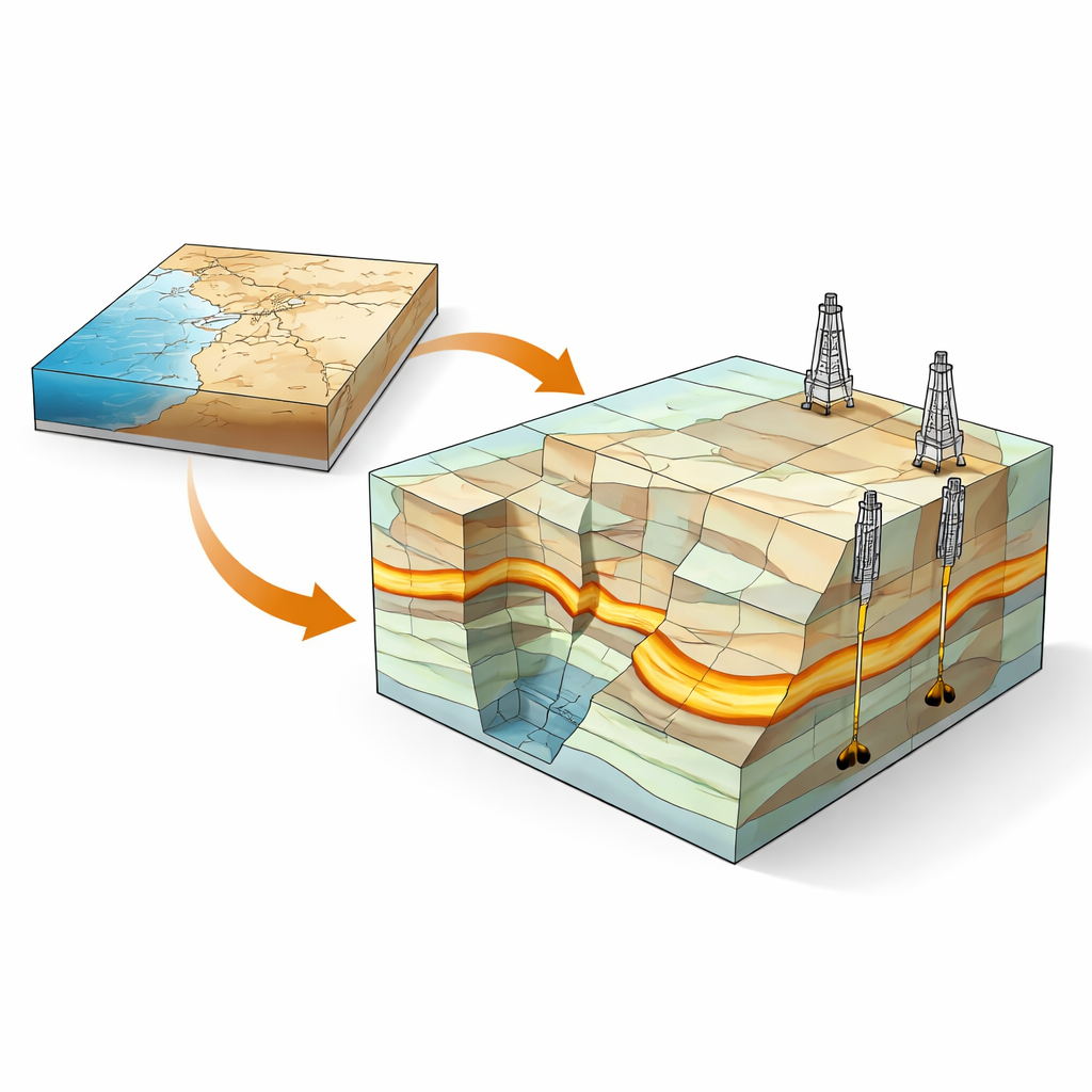
A Closer Look Beneath the Gulf of Suez
The Nukhul Formation is an ancient package of river and fan sediments buried several kilometers below the seafloor. Over millions of years, shifting faults broke the area into tilted blocks, creating a maze of rock compartments that can trap or leak oil. Earlier models of this labyrinth were built with sparse well data and low‑resolution seismic images, so engineers could not reliably trace where the best sand bodies lay or how they connected. As production from Nukhul slowed, it was easy to conclude that the reservoir was simply exhausted.
Building a 3D Underground Map
The researchers revisited the field with a much richer toolbox: four decades of well logs, core samples, production histories, and newly reprocessed seismic lines. They integrated all of these into a modern 3D static model, which describes the shapes of rock layers, their pore space, and how much sand versus shale they contain. Instead of treating the Nukhul as a single uniform reservoir, they divided it into four vertical zones, K1 through K4, each with distinct rock types and flow behavior. This step was crucial for turning blurry averages into a crisp picture of where oil actually resides.
Separating Sealing Rocks from Flowing Sands
The new model shows that the upper two zones, K1 and K2, are dominated by tight limestone, shale, and basalt. These layers barely store or transmit fluids but act as effective seals, capping oil in the rocks below and stopping it from leaking upward. In contrast, the lower zones, K3 and especially K4, contain the sandy river and fan deposits that make up the true reservoir. K3 holds thinner, patchy sand lenses that are hard to connect into a large, efficient target. K4, however, consists of thick, laterally continuous sandstone channels with good porosity and permeability, arranged mainly in north–south belts controlled by a major fault called F2.
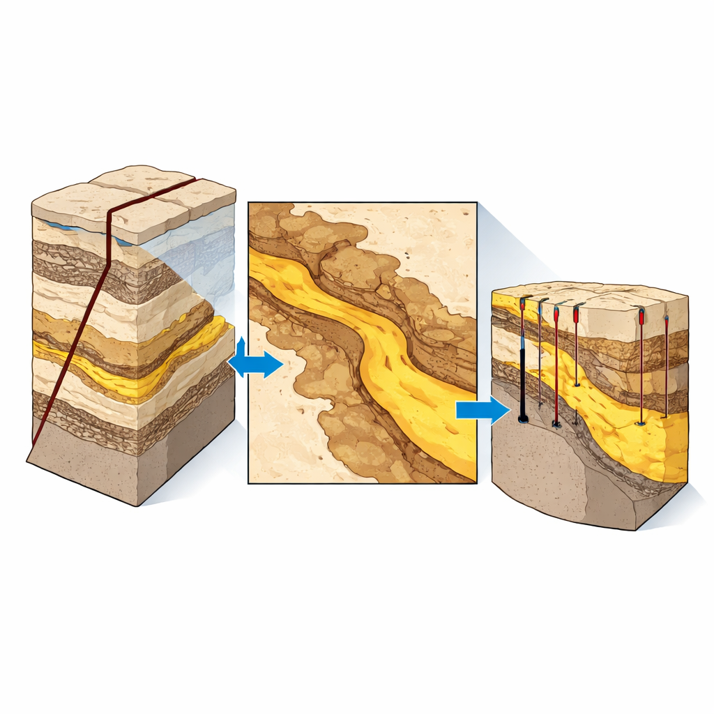
Finding Sweet Spots in a Broken Landscape
By overlaying maps of sand thickness, shale content, and porosity onto the structural model, the team pinpointed corridors where clean, well‑sorted sandstones are thickest and least contaminated by shale or cement. They also evaluated how faults seal or leak, identifying blocks where oil can accumulate in “attic” positions above the current water level. The K4 interval emerged as the star performer: in some layers, sandstone dominates and forms wide channels that match areas of strong well productivity. The model highlights several undrilled structural highs and channel segments that should host remaining oil, some close enough to be tapped by low‑cost sidetrack wells from existing platforms.
Why This Matters for Energy and Beyond
For a lay reader, the core message is that detailed underground mapping can turn a “tired” oil layer back into a valuable resource. The study demonstrates that production from the Nukhul Formation is limited less by geology itself and more by how well we understand it. With an updated 3D picture of faults, sealing layers, and buried river channels, operators can plan smarter wells, avoid water‑rich zones, and target the most promising sand bodies, potentially adding thousands of barrels per day. Beyond this single field, the same integrated approach can be applied to other rifted basins, showing how modern imaging and modeling can extend the life of existing energy infrastructure while reducing the guesswork in subsurface decision‑making.
Citation: Khattab, M.A., Radwan, A.E., El-Anbaawy, M.I. et al. Integrated 3D static modelling to assess hydrocarbon potential of the fluvial-alluvial sandstones of Nukhul Formation, October oil field, Gulf of Suez, Egypt. Sci Rep 16, 10624 (2026). https://doi.org/10.1038/s41598-026-42298-1
Keywords: Gulf of Suez, Nukhul Formation, 3D reservoir modelling, faulted oil fields, fluvial sandstones