Clear Sky Science · en
An assessment and collaborative governance of the non-motorized environment potential of commercial TOD based on the improved NPP model
Why the Space Around Metro Stations Matters
For many city dwellers, the walk to and from a metro station is a daily ritual. These short trips, done on foot or by bicycle, shape how safe, welcome, and included people feel in their own city. This paper looks at the spaces around busy commercial metro stations in Xi’an, China, and asks a simple but powerful question: do these areas serve everyone fairly, or do they quietly favor some groups over others? By blending ideas of fairness with detailed mapping and street-level data, the authors show how station areas can be redesigned to be both efficient transport hubs and pleasant, dignified places for everyday life.
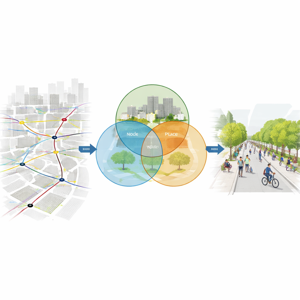
Three Ways to Look at a Station Area
The study introduces a three-part lens called the “Node–Place–Perception” model. The “node” view treats a metro station as a transport knot: how easy is it to reach on foot, by bus, or by bike, and how well does it connect to the rest of the network? The “place” view looks at the surrounding urban fabric: are there shops, services, homes, and public spaces mixed together, and is the street layout friendly to people who are walking or cycling? The “perception” view focuses on how ordinary users feel in these spaces: do they sense safety, comfort, greenery, light, and a welcoming atmosphere? By combining these three angles, the model moves beyond counting trains and buildings to capture how well a station area supports real human lives.
Turning Digital Traces into a Fairness Score
To test this model, the researchers studied 14 commercial station areas in Xi’an. They gathered a rich mix of data: metro and bus information, land-use maps, online check-ins, night lighting, open street maps, and tens of thousands of street-view images. Using machine learning, they extracted features like how much greenery and sky people can see, how continuous the road network is, and whether motor vehicles are separated from bikes and pedestrians. Expert judgment and statistical methods were combined to assign importance to each indicator, so that both professional insight and real-world variation shaped the final scores. Each station area was then located within a three-dimensional grid defined by its node, place, and perception performance.
Four Patterns of (In)Justice Around Stations
The results reveal clear patterns in how these station areas function. Most fell into a “balanced” category, where transport access, built form, and user experience are reasonably aligned. A smaller group showed “place imbalance,” where transit access is decent but surrounding streets and land uses are weak or one-sided, leaving people with few reasons to linger or walk. Another group suffered from “perception imbalance”: the physical layout and transport links look fine on paper, but a lack of greenery, seating, lighting, or welcoming public space makes people feel uncomfortable or unsafe. One station, Anyuanmen, was “completely imbalanced,” scoring low on all three dimensions, partly because strict historic-preservation rules limit new buildings and public plazas. In these cases, the authors argue, the problem is not just design but fairness: some areas effectively deny people equal quality of access and experience.
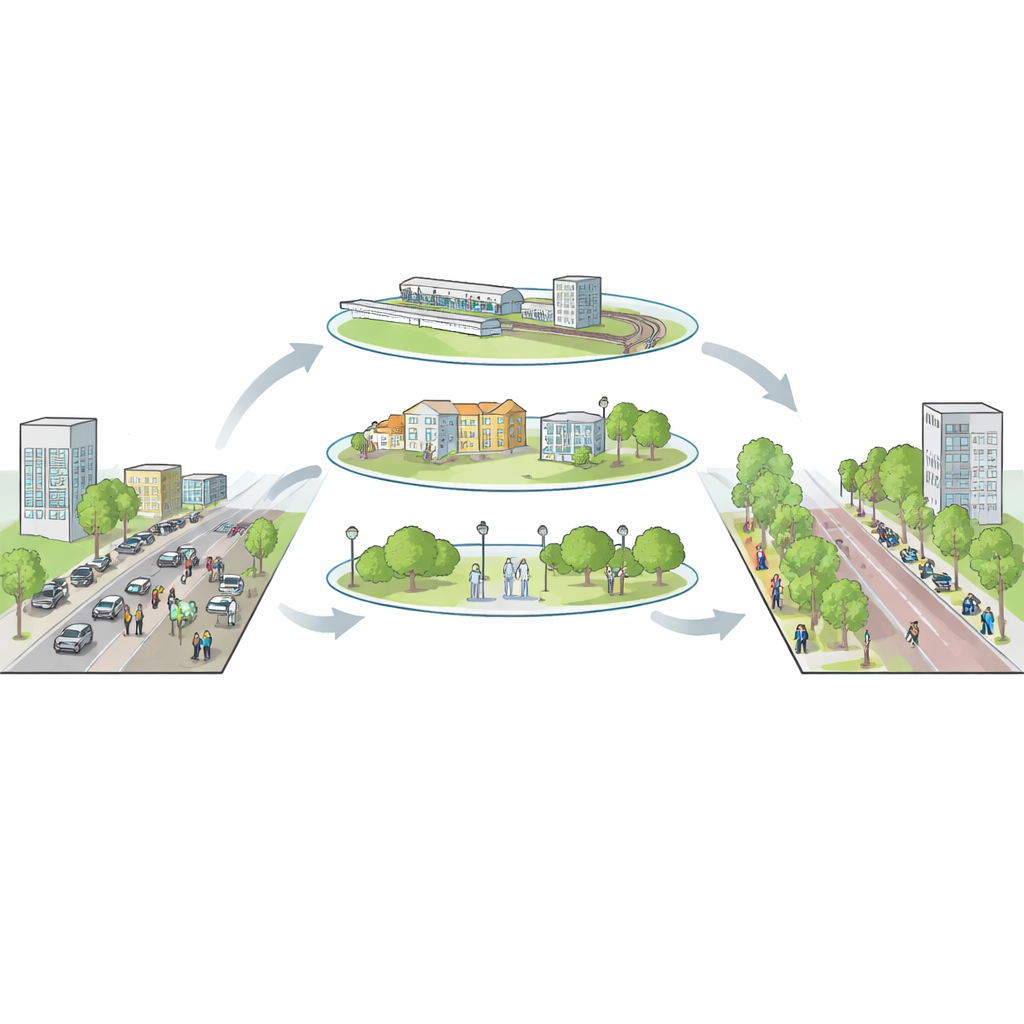
Designing Fairer Streets for Everyone
Building on this diagnosis, the paper outlines tailored improvement strategies. For stations where the transport side is weak, the authors propose better bus–metro links, clearer walking routes, and organized parking for bikes and scooters. Where place functions lag, they suggest adding everyday services within a short walking radius and reshaping key streets with wider sidewalks and more greenery. For perception problems, small-scale interventions—pocket parks, street trees, comfortable seating, and human-scaled lighting—can greatly lift people’s sense of safety and belonging. In the most troubled areas, they call for staged, long-term efforts that carefully balance heritage protection with new public spaces and mixed uses, so that historic zones can also feel alive and inclusive.
What This Means for City Life
In plain terms, the study shows that the space around metro stations is not just a backdrop for movement; it is a test ground for how fair and humane a city really is. By treating people’s feelings of comfort and dignity as essential data—alongside transport efficiency and land use—the Node–Place–Perception model offers city planners a practical way to spot hidden problems and guide upgrades. Applied widely, this approach could help transform commercial station areas from crowded, stressful funnels into vibrant, walkable districts where efficient travel and social inclusion grow together.
Citation: Duan, Y., Ma, Y., Liu, Y. et al. An assessment and collaborative governance of the non-motorized environment potential of commercial TOD based on the improved NPP model. Sci Rep 16, 11983 (2026). https://doi.org/10.1038/s41598-026-41044-x
Keywords: transit-oriented development, walkable cities, spatial justice, metro station design, urban public space