Clear Sky Science · en
An integrated multidimensional risk framework for volcanic hazard zones: insights from Mt. Vesuvius, Italy
Living in the Shadow of a Volcano
Millions of people around the world live close to active volcanoes, often without a clear picture of how much danger they face. Around Mt. Vesuvius in southern Italy, more than 600,000 people share their daily lives with a volcano famous for burying Pompeii in 79 CE. This study asks a simple but vital question: not just where the lava and hot flows might go, but where people and buildings are most likely to be harmed. By combining information on the volcano’s behavior with detailed maps of neighborhoods and homes, the authors build a clearer picture of who is really at risk, and where help and planning are most urgently needed. 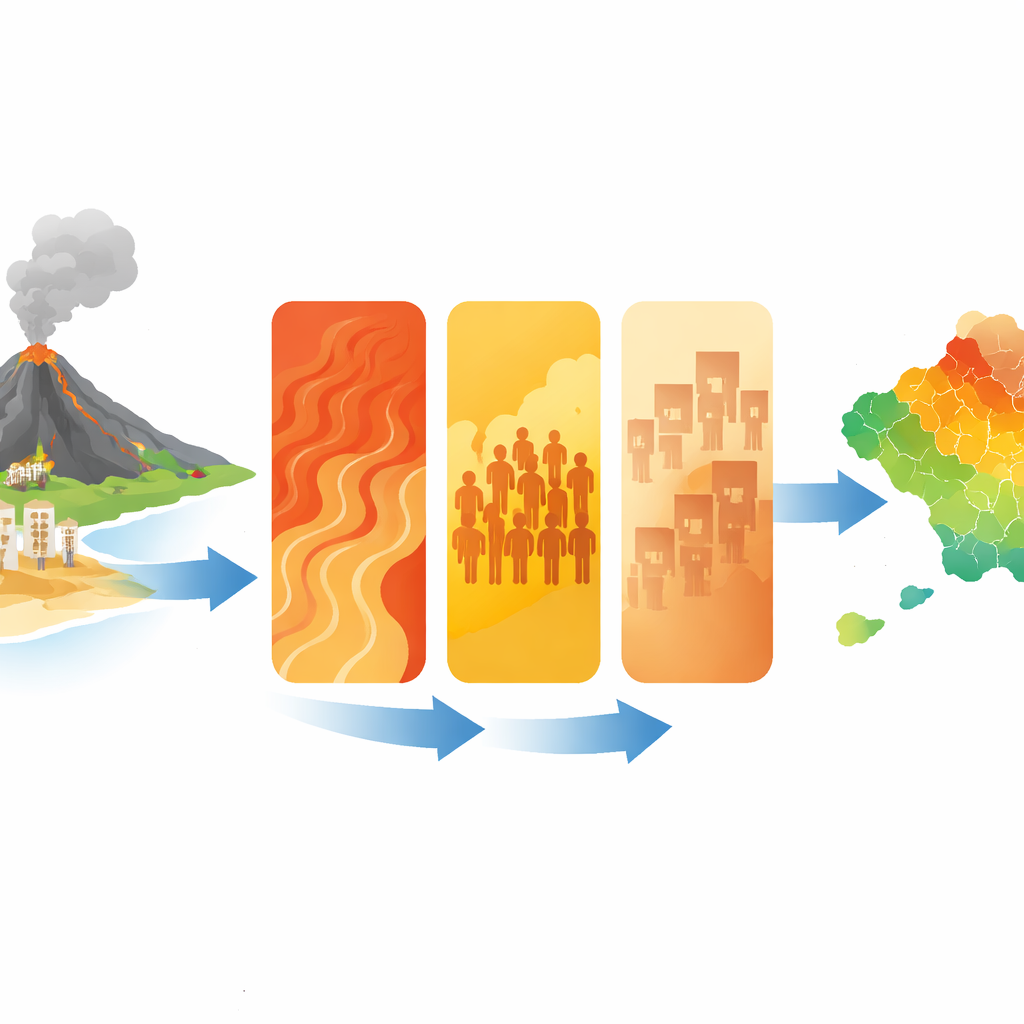
From Eruption to Everyday Life
Traditional hazard maps around Vesuvius outline zones where dangerous phenomena, such as fast‑moving clouds of hot ash and gas called pyroclastic density currents, are likely to reach. These maps are crucial, but they mainly show where the natural threat exists, not how it overlaps with the people and buildings that could be harmed. The Italian Civil Protection Department already divides the region into a central “Red zone” and a broader “Yellow zone,” but these two categories say little about how risk changes from one street or neighborhood to the next. In a crowded metropolitan area like Naples, such broad zones are too coarse to guide detailed evacuation plans, building upgrades, or local emergency drills.
Bringing People and Places into the Picture
The researchers create a multidimensional framework that treats risk as the combined result of three elements: the volcanic hazard itself, the number of people and buildings in harm’s way (exposure), and how fragile those people and structures are (vulnerability). They focus on long‑term hazard from pyroclastic density currents, estimating where these hot flows could go and how intense they might be. At the same time, they use high‑resolution census data to count residents and buildings in small statistical units called Enumeration Areas, and they capture social factors such as age structure and income, along with physical traits like building types and construction quality. By standardizing these varied data into common scales, they can stack and compare them across the entire Vesuvius region.
Turning Complex Data into Clear Maps
Using statistical tools and geographic information systems, the team converts dozens of separate measurements into three composite indexes: one each for hazard, exposure, and vulnerability. Each index is graded from very low to very high and mapped across thousands of tiny areas around the volcano. Hazard is highest on and near the slopes of Vesuvius and gradually fades with distance. In contrast, exposure and vulnerability tend to peak in the densely built, socially fragile urban districts closer to the coast and to the northwest of the volcano. When the three indexes are combined into a single volcanic risk map, the result reveals sharp contrasts: many neighborhoods around the volcano fall into lower‑risk categories, while pockets in municipalities such as Sant’Anastasia, Volla, Cercola, San Sebastiano al Vesuvio, Ercolano, Portici, and parts of Naples stand out as hot spots of very high risk. 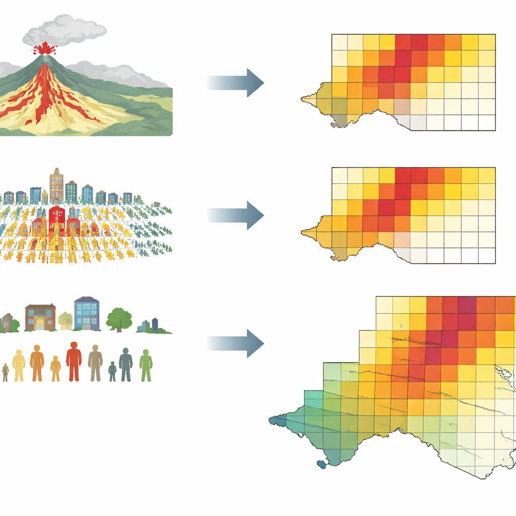
What the New Risk Map Reveals
The numbers highlight how much is at stake. Nearly 89% of residents and more than 92% of buildings in the study area are located where some level of volcanic risk exists, and over one third of the population lies in the very highest risk class. Because the framework pinpoints which areas are driven mainly by high hazard, high exposure, or high vulnerability, it also suggests tailored responses. In some towns, strengthening buildings and supporting vulnerable households may yield the greatest safety gains; elsewhere, careful land‑use planning, better monitoring, and more refined evacuation routes may matter most. The authors also show how their five‑level risk map can guide step‑by‑step strategies, from basic public awareness in low‑risk areas to intensive protection and rapid‑evacuation planning in zones of very high risk.
Beyond Vesuvius: A Tool for Safer Cities
To a non‑specialist, the main message is straightforward: risk from a volcano is not just about how dangerous the eruption could be, but about who and what stands in its way. By weaving together physical science, social data, and urban geography, this study offers a practical blueprint for local authorities who must decide where to invest in prevention, how many people might need to be moved, and which neighborhoods require the most support. Although developed for Mt. Vesuvius, the same approach could be adapted to other volcanic regions and even to different natural hazards, helping communities worldwide live more safely with the restless landscapes that surround them.
Citation: Lapietra, I., Benassi, F., García-Pereiro, T. et al. An integrated multidimensional risk framework for volcanic hazard zones: insights from Mt. Vesuvius, Italy. Sci Rep 16, 10029 (2026). https://doi.org/10.1038/s41598-026-40589-1
Keywords: volcanic risk, Mt. Vesuvius, hazard mapping, social vulnerability, disaster planning