Clear Sky Science · en
Overlying strata movement characteristics and water conducting fracture zone height prediction for deep coal mining in arid Western China
Why digging deep for coal affects land and water
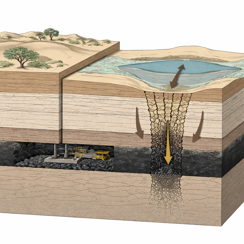
In the dry heart of western China, towns and industries depend on scarce underground water that lies above rich coal seams. As mines chase coal deeper underground, engineers worry that the rocks separating coal from precious aquifers may crack, creating hidden pathways for water to drain away or flood tunnels. This study investigates how unusually soft, thick sandstone above deep coal seams in the Ordos Basin bends, flows, and breaks during mining, and what that means for land stability and groundwater security.
A special kind of soft rock above the coal
The coalfields of the Ordos Basin are capped by ultra-thick "weakly cemented" sandstones—rock that looks solid but behaves more like a firm, porous sponge than a rigid beam. Unlike the tough roof rocks above many coal mines around the world, these sandstones have low strength, high porosity, and are easily damaged by stress and water. As mining moves deeper, traditional rules of thumb about how roofs break and how far cracks climb become unreliable. The authors set out to understand how this soft overburden really moves, so that engineers can better predict ground sinking at the surface and the risk of water flowing through newly formed fractures.
Rebuilding the underground in the laboratory
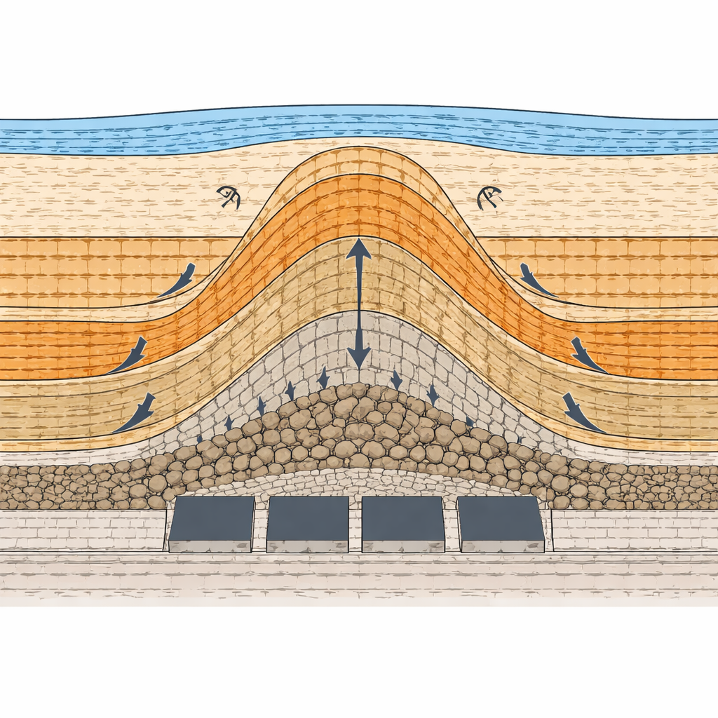
To watch the rocks move in slow motion, the team built a large-scale physical model with carefully mixed sands, gypsum, and other materials chosen to mimic real rock layers at one five-hundredth of their actual size. They simulated longwall mining of individual and then multiple adjacent panels, while high-precision cameras tracked thousands of tiny markers to capture every subtle shift. When a single 300-meter-wide panel was mined, the main roof above it stayed still at first and then suddenly began to sag once the excavation advanced to about 150 meters. By the time the full width was extracted, the model roof had dropped the equivalent of 5.55 meters, and the influence of mining had spread upward into higher rock layers.
From brittle breakage to slow bending and flow
As mining continued across several neighboring panels, the behavior of the overlying strata changed in a striking way. Lower, tougher layers near the coal broke into blocks and beams, forming sharp-edged collapse zones. In contrast, the overlying ultra-thick Cretaceous sandstone did not shatter. Instead, it bent smoothly over a wide area and deformed plastically, flowing downward in the middle while rotating on both sides. The displacement field could be divided into a central "subsidence zone" with near-vertical sinking and flanking "rotation zones" where rocks tilted toward or away from the mined-out area. This large, coordinated bending pattern meant that fractures could rise higher than expected without obvious, clean breaks.
Peering inside the rock to explain its strange behavior
To understand why this sandstone behaved so differently, the researchers tested core samples in a high-pressure triaxial machine and imaged them with a scanning electron microscope. The mechanical tests showed low overall strength and a strong dependence on confining pressure: at low pressure, the rock split and sheared; at higher pressure it behaved more like a slowly flowing material, shedding grains without forming big open cracks. Microscopic images revealed well-rounded quartz grains with many pores between them and only thin, patchy films of weak calcite and feldspar acting as glue. Energy-dispersive X-ray analysis confirmed this fragile cement. Together, these features make the sandstone easily squeezed, bent, and slowly crushed, rather than snapping like a rigid beam.
Simulated mining and the rise of water pathways
The team then translated the layered rock column into a numerical model using a widely used distinct-element code. By digitally advancing six longwall panels, they tracked how horizontal and vertical stresses shifted, where layers separated, and where rock failed in tension, shear, or a mix of both. The model showed strong horizontal separations at the base of the thick weak sandstone and within a lower sandstone unit, with stress cycling between stretching and squeezing as each new panel was mined. These cycles gradually weakened the rock and encouraged a tall, arch-shaped fracture zone to grow upward. Both simulations and field data from boreholes indicated that the water-conducting fracture zone can climb as high as about 186 meters, reaching the base of an overlying Jurassic unit once the width of mining becomes more than one and a half times the burial depth.
What this means for coal, land, and water
For a lay reader, the key message is that not all rock roofs behave alike. In the Ordos Basin, a thick, soft sandstone layer bends and flows under the weight of overlying strata as coal is removed beneath it. This unusual response allows fractures that can carry water to extend surprisingly high, even when the surface looks gently sagged rather than sharply broken. By combining physical models, lab tests, microscopic analysis, and computer simulations, the study provides a practical formula to estimate how tall the water-bearing fracture zone will grow for a given mining layout. These insights can help planners design panel widths, support systems, and water-protection measures that keep both miners and scarce groundwater resources safer in this and other arid coal regions with similar geology.
Citation: Du, Q., Guo, G., Li, H. et al. Overlying strata movement characteristics and water conducting fracture zone height prediction for deep coal mining in arid Western China. Sci Rep 16, 14156 (2026). https://doi.org/10.1038/s41598-026-46768-4
Keywords: deep coal mining, weakly cemented sandstone, groundwater protection, overburden deformation, water-conducting fractures