Clear Sky Science · en
Characterization of newly identified N–S shear zones in the Egyptian Nubian Shield by integrating geophysical, remote sensing and field data
Rivers of rock beneath our feet
Deep under the deserts of Egypt, the rocks themselves have flowed and fractured over hundreds of millions of years. This study traces a set of huge hidden “corridors” in the Earth’s crust that run north to south across the Egyptian Nubian Shield. These zones, where rocks have been slowly sheared and shifted, help scientists understand how a large piece of ancient Earth’s surface was stitched together and later pulled apart, and why certain regions are favorable for valuable minerals such as gold.
A three-part ancient landscape
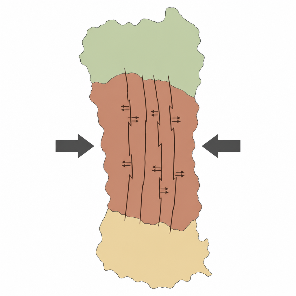
The Egyptian Nubian Shield is part of the vast East African mountain belt that formed more than 600 million years ago when pieces of the supercontinent Gondwana collided. The authors divide this region into three broad belts. In the south, rocks were mainly squeezed together, preserving traces of old ocean crust and island arcs that crashed into each other. The central belt records both squeezing and sideways motion, while the northern belt shows signs of stretching. Together, these zones tell the story of how an early chain of volcanic islands was first built, then welded to older African crust, and finally reshaped after the main collisions ended.
Finding long hidden fractures
To map structures that are too large to see in the field and too deep to reach directly, the team combined satellite images, measurements of Earth’s gravity field, and detailed ground observations. Variations in gravity reveal changes in rock density at depth, while remote sensing highlights subtle differences in rock type and alteration at the surface. Using special filters on the gravity data, the authors enhanced long, straight lineaments that mark buried faults and shear zones. These tools, checked and refined by field mapping, uncovered a dominant family of north–south corridors of deformation that cut across the central and southern parts of the shield, some more than 100 kilometers long.
New north–south corridors of motion
The study identifies and describes six major north–south shear zones: Safaga–Shalul, Wadi Kareim–Umm Bisilla, Um Gheig–Nugrus, Barramiya–Mueilha, Abu Swayel–Muqsim, and Himitrah–Madari. Within these zones, once-solid rocks have been stretched, folded, and ground into fine-grained bands called mylonites. Microscopic features and field-scale patterns show that, for much of their history, these corridors moved in a right-lateral sense, meaning blocks on opposite sides slid past one another horizontally. Later, as the region was uplifted and the Red Sea rift opened, some of these same corridors were reactivated in the opposite, left-lateral, sense as more brittle faults. In many places, the shear zones also guided the rise of molten rock and the flow of mineral-rich fluids.
A linked web of fractures
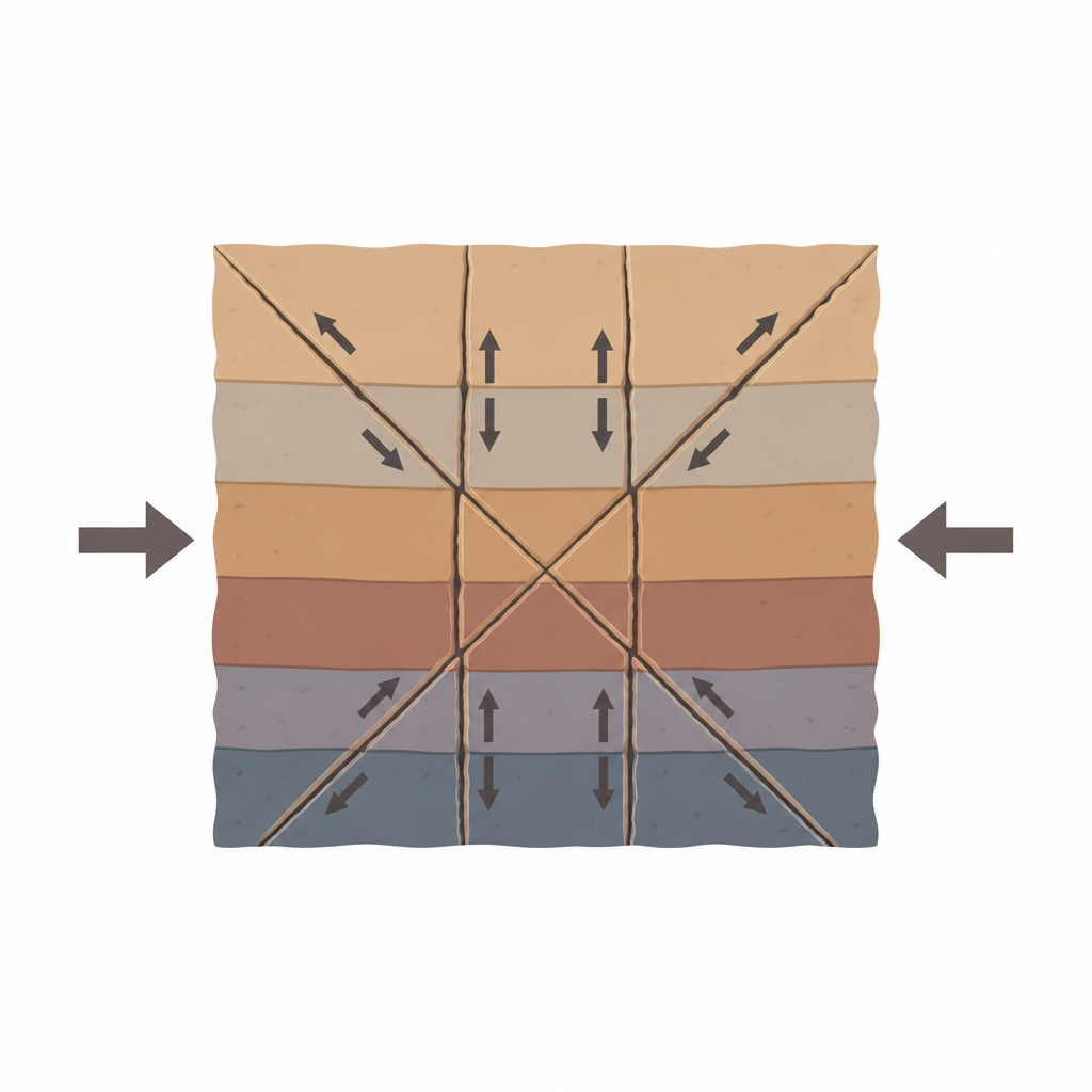
The north–south corridors do not act alone. They form a geometric network with older northwest–southeast and younger northeast–southwest shear zones tied to the vast Najd Fault System of the Arabian–Nubian Shield. The authors show that these three directions of shearing behave like a set of linked cracks created under a long-lasting sideways squeeze. The northwest-trending zones are the main “master” faults, while the north–south and northeast-trending zones act as companion fractures that share and redirect the strain. This pattern extends below the surface and appears to connect with even larger structures in Sudan, such as the Hamisana shear zone and the Keraf suture, which mark boundaries between different continental fragments.
What this means for Earth history
By tracing these newly recognized north–south shear zones and fitting them into a five-stage sequence of deformation, the study clarifies how the Egyptian Nubian Shield evolved after the main continent-building collisions. It shows that long-lived sideways squeezing first produced northwest faults, then reoriented the stress field to activate north–south corridors, and finally shifted again to favor northeast shearing and later brittle faulting during Red Sea opening. For non-specialists, the key point is that the solid crust beneath Egypt once flowed like an extremely slow, viscous material, breaking into giant sliding slabs along preferred directions. These deep “rivers of rock” controlled where mountains rose, where the crust later stretched, and where fluids concentrated metals, leaving a structural blueprint that still influences today’s landscape and mineral resources.
Citation: Abd El‑Wahed, M.A., Eldosouky, A.M. Characterization of newly identified N–S shear zones in the Egyptian Nubian Shield by integrating geophysical, remote sensing and field data. Sci Rep 16, 16145 (2026). https://doi.org/10.1038/s41598-026-46327-x
Keywords: Egyptian Nubian Shield, shear zones, Najd Fault System, East African Orogen, crustal deformation