Clear Sky Science · en
Three-dimensional spatial representation method for semantic boundaries in digital outcrop models
Seeing rock walls in a new way
Rocky cliffs store clues about ancient seas, buried resources, and past earthquakes, but reading those clues still relies heavily on people sketching what they see on steep, hard to reach walls. This study shows how drones, smart image analysis, and 3D computer models can team up to turn a rough cliff face into a detailed, interactive digital copy where different rock types and hidden boundaries are mapped with centimeter level precision. 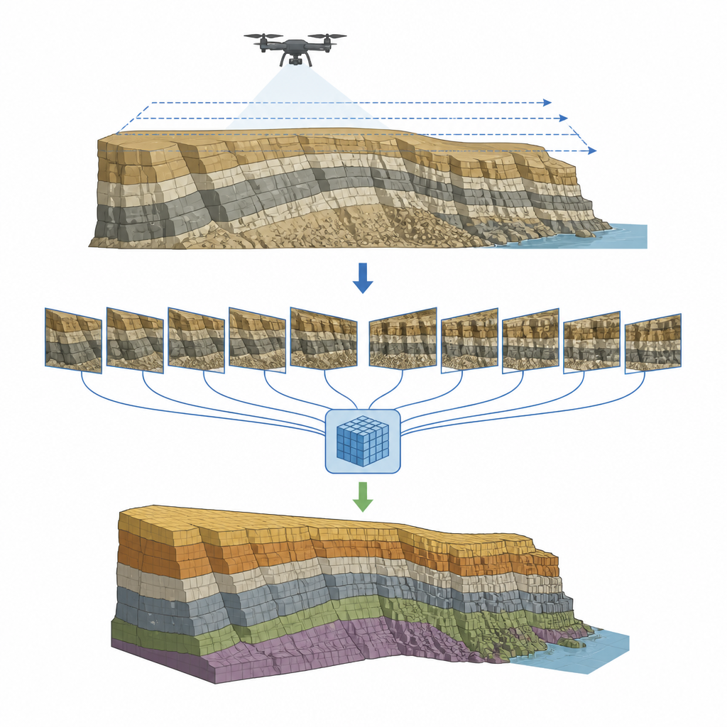
Why cliffs matter for energy and hazards
In the deserts of Xinjiang, China, layers of ancient sea floor are exposed in towering walls of rock called outcrops. These layers can form underground reservoirs that trap oil, gas, and water, and they also record how the region folded and broke during long geologic history. Knowing exactly where one rock type ends and another begins helps assess which layers store fluids, how faults might guide or block flow, and where future landslides or fractures could develop. Yet walking every meter with a tape measure and notebook is slow, risky work that struggles to keep up with the needs of modern resource exploration and hazard monitoring.
Flying cameras over the rock face
The team focused on the Xiaoerbulake outcrop, a thick stack of shallow sea carbonates from the Cambrian period. They used a professional multirotor drone fitted with five cameras that look straight down and from four angles to gather more than 5,200 overlapping images at roughly two to three centimeters per pixel. Careful flight planning kept the drone at a steady height with high forward and side overlap, and images were later cleaned for lighting and distortion. These dense, crisply detailed photographs capture the shape of each ledge, the subtle color shifts between rock types, and the lines of folds and faults that cut across the wall.
Teaching a network to trace rock boundaries
To turn raw pictures into meaningful maps, the researchers trained an improved version of a popular image analysis network called U Net. Experienced geologists hand labeled 850 image patches, marking three key carbonate rock types plus background. The network was redesigned to pay special attention to edges, using multi scale filters to see both broad bands and fine textures and an internal attention module that highlights likely boundaries while muting noisy surroundings. A custom loss function gives extra weight to thin boundary zones so the model learns to draw crisp lines instead of fuzzy transitions. In tests against several widely used methods, this improved network achieved the best scores, especially for how sharply and accurately it traced rock contacts.
Building a smart 3D cliff
The next step was to move from flat pictures to a full 3D model. Using standard "structure from motion" and multi view stereo techniques, the team reconstructed a detailed digital mesh of the outcrop with realistic surface texture. Knowing the exact position and viewing angle of each drone image, they projected the 2D rock labels back onto the 3D surface. A depth test removes views where a point is hidden behind closer rock, and a weighted voting scheme prefers labels from camera angles that look more directly at the surface. The result is a colored 3D cliff where each triangle carries a rock type label, and checks against control points showed a typical mapping error of only a few centimeters. 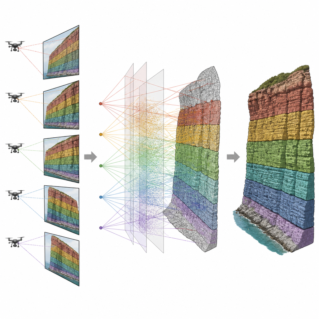
Exploring the digital cliff at different scales
To make the model useful in practice, the authors built a web based viewer using the Cesium 3D mapping platform. They created several levels of detail, from lightweight meshes that show only main bands and structures to denser versions suited for close inspection. Users can zoom from a broad regional view down to specific ledges, seeing how different rock bodies connect in space while keeping performance smooth. Colors and transparency change with scale so that the most relevant boundaries stand out without clutter.
What this means for future field work
For non specialists, the key idea is that cliffs can now be turned into precise, interactive digital twins where rock types and structural lines are traced automatically rather than by hand. In the Xiaoerbulake case, the method clearly outperformed standard image tools and kept mistakes in 3D mapping within a few centimeters. That level of detail can sharpen estimates of where oil, gas, or water might be stored and help scientists understand how the ground has shifted over time. As drones and artificial intelligence continue to improve, similar systems could become routine tools for geologists, making field studies faster, safer, and more informative.
Citation: Dong, Z., Zhang, H., Qu, Y. et al. Three-dimensional spatial representation method for semantic boundaries in digital outcrop models. Sci Rep 16, 15170 (2026). https://doi.org/10.1038/s41598-026-45820-7
Keywords: digital outcrop, drone geology, 3D geological modeling, semantic segmentation, geological boundaries