Clear Sky Science · en
Analysis of water-permeable fractured zone in weakly cemented overburden considering rock strain-softening
Why Cracks Above Coal Mines Matter
In dry regions where water is scarce, coal mines do more than remove fuel from underground – they can also open hidden cracks that drain precious groundwater and trigger sudden floods into mine tunnels. This study looks at how these fracture zones grow above a longwall coal mine in western China, where the overlying rocks are weak and easily damaged. By combining field measurements with advanced computer simulations, the authors show that common engineering methods can underestimate how high these water‑carrying cracks reach, with serious implications for both mine safety and local ecosystems.
The Hidden Pathways for Water
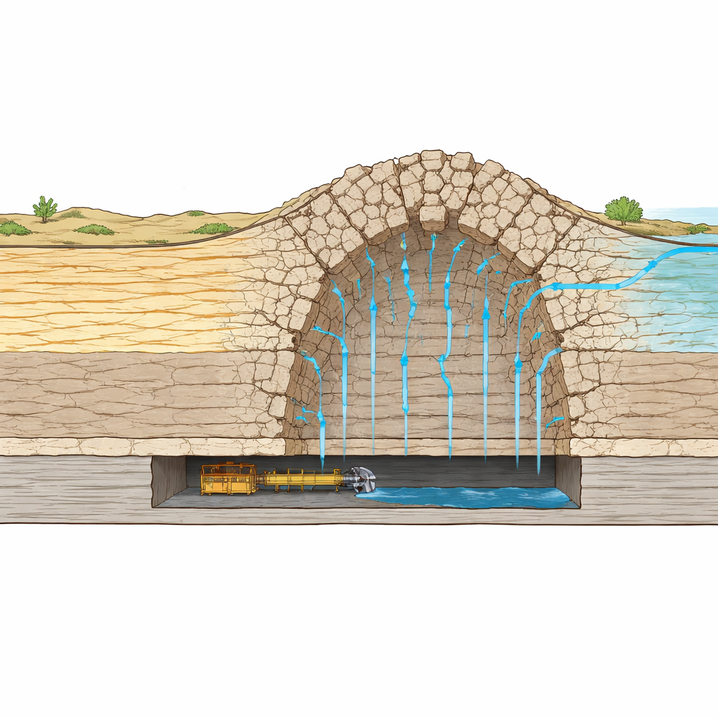
When a coal seam is mined out over a large area, the rock roof above the empty space sags, bends, and eventually breaks. This process creates a “water‑permeable fractured zone” – a column of interconnected cracks and gaps through which water can flow. In the Shendong mining area of Inner Mongolia, coal seams lie beneath loose sand and weakly cemented sandstone and mudstone. Once disturbed, these rocks can fracture extensively, linking shallow water‑bearing layers to the mine void. That connection can drain groundwater, cause sudden inflows of water and sediment into tunnels, and worsen surface problems such as soil erosion, vegetation loss, and contamination of already limited water resources.
Measuring Cracks from the Surface
To find out how high the fractured zone actually extends, the researchers drilled two vertical boreholes: one above undisturbed ground and one above the mined‑out area, or goaf. During drilling, they watched how much flushing fluid leaked into the surrounding rock and how the water level in each hole changed. In the undisturbed hole, leakage stayed low and steady, indicating only sparse natural fractures. In contrast, once drilling in the mined area reached about 97 meters depth, fluid loss jumped by thousands of times and the water level suddenly dropped to the bottom of the hole, showing that the bit had entered a highly cracked and water‑conductive zone. Borehole video images confirmed this picture: intact rock at shallow depths gave way to dense, crisscrossing fractures at greater depths. From these observations, the height of the water‑permeable fractured zone was determined to be about 142.6 meters above the coal seam.
Why Traditional Formulas Fall Short
Engineers in China often rely on an old empirical formula that estimates the fracture‑zone height from the mining thickness and a broad description of roof rock hardness. For the studied coal face, this rule of thumb predicted only about 41 meters of fracturing – far below what the boreholes revealed. One reason is that the formula was developed mainly from older, harder rock types in eastern coalfields and does not reflect the weaker, more variable rocks in western basins. As a result, using it in such settings can give a falsely low sense of security, underestimating both the potential for groundwater loss and the risk of water inrush to the mine workings.
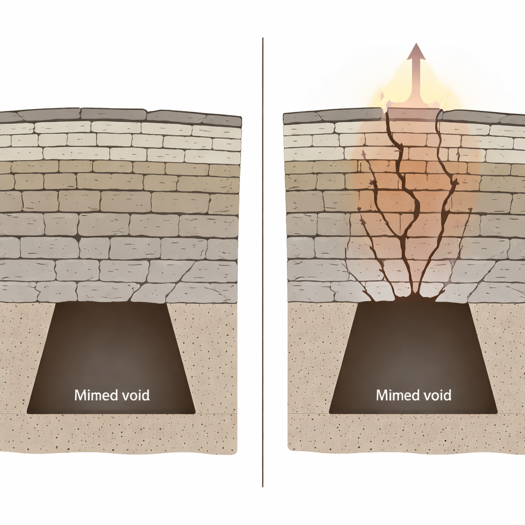
Rocks that Weaken as They Deform
To address this gap, the authors built a three‑dimensional numerical model of the mine using a distinct element method, which represents the overburden as interacting blocks separated by joints. They compared two ways of describing rock behavior: the standard Mohr–Coulomb model, which assumes that once rock reaches its peak strength it stays equally strong thereafter, and a strain‑softening model, in which strength gradually decreases as deformation accumulates. The softening model captures how micro‑cracks grow and bonds break inside weakly cemented rocks, causing them to lose cohesion and friction over time. Simulations showed that both models reproduced the general pattern of roof sagging, caving, and crack growth, but the details differed in important ways.
Seeing the Full Extent of Damage
With the constant‑strength model, failures remained mostly in the lower roof, and the fractured zone reached only about 128.5 meters. In the strain‑softening simulations, however, once the rock above the goaf started to fail it weakened progressively, allowing cracks to extend higher and wider. Earlier separations in the roof closed under subsidence, while new fractures formed further up, creating a taller, more continuous water pathway. This model predicted a fractured‑zone height of 144.5 meters – within a couple of meters of the borehole measurements and significantly higher than the Mohr–Coulomb estimate. Throughout mining, the softening model consistently produced larger, more realistic damaged areas, highlighting how sensitive fracture growth is to the way post‑failure rock behavior is treated.
What This Means for Water and Safety
For non‑specialists, the message is straightforward: in weak, water‑bearing rocks, the cracking above a coal mine can reach much higher than simple rules suggest, especially when the rock continues to weaken after it first breaks. Models that ignore this softening tend to under‑predict how far water can travel downward into a mine. By matching field data closely, the strain‑softening approach offers a more trustworthy basis for designing safe mining depths, planning water protection measures, and assessing environmental impacts in arid regions where groundwater is both precious and fragile.
Citation: Xue, S., Wang, Q. & Song, Z. Analysis of water-permeable fractured zone in weakly cemented overburden considering rock strain-softening. Sci Rep 16, 10776 (2026). https://doi.org/10.1038/s41598-026-45413-4
Keywords: coal mining, groundwater, rock fracturing, numerical modeling, mine water hazards