Clear Sky Science · en
Exploring cross-regional and cross-variable transferability of a ResNet-based super-resolution method for the ERA5 data
Why sharper weather maps matter
Weather forecasts, climate-risk maps, and heat-wave alerts are all built on gridded data about temperature, wind, and pressure. But these data are often too coarse to show what is happening over a particular city, coastline, or valley, and traditional ways of sharpening them are slow and expensive. This study shows how a modern artificial-intelligence technique can turn blurry global weather data into sharper fields much more quickly—and, crucially, how a single trained model can be reused across different parts of the world and even for different weather variables, cutting both computing costs and data needs.
From blurry grids to finer detail
Most global weather and climate information comes from reanalysis products such as the ERA5 dataset, which blend observations with physics-based models. These data are gridded at intervals of about 25 kilometers, fine for large-scale patterns but too coarse for local details. Traditionally, scientists have filled gaps or increased resolution using methods called data assimilation or interpolation. While effective, these techniques demand heavy computing power and must be re-run for each region and variable. The authors explore an alternative: a deep-learning model based on a residual neural network (ResNet) combined with a “sub-pixel” module that is designed specifically to reconstruct missing fine-scale structure, a task known as super-resolution. 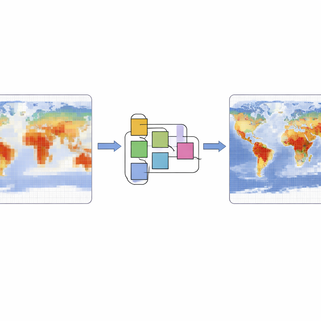
Teaching an AI model once, using it many times
The core question is whether a super-resolution model trained in one place can be reused elsewhere instead of retraining from scratch. The team first trains their ResNet-based model on one large box over East Asia using near-surface air temperature at two-meter height. Low-resolution inputs are created by deliberately coarsening the original ERA5 data by factors of two and four, and the model is taught to reconstruct the original high-resolution fields. After training, the authors apply this same model—without retraining—to 15 other regions scattered across mid-latitude oceans and continents, and compare its output to the true ERA5 fields using multiple error and similarity measures.
Oceans are easier, land is harder
The results show that the model’s skill does transfer: across all 16 regions and two zoom levels, the AI reconstruction is consistently closer to the original data than standard interpolation methods. Performance is best over open ocean, where temperature patterns change gradually and the environment is relatively uniform. Boxes covering only sea surface show the smallest errors and highest similarity to the reference fields. Over land, where mountains, coastlines, and strong day–night contrasts introduce sharp variations, performance drops somewhat but remains useful. Longer-term averages further improve agreement, because the model’s small moment-to-moment errors tend to cancel out when many hours are averaged together.
One model for many kinds of weather data
Super-resolution is not just about temperature. In a second set of tests, the authors feed the pretrained model other near-surface ERA5 variables from selected regions: sea-level pressure, the two horizontal wind components, and dew point temperature, which is a measure of humidity. Despite never being trained on these variables, the network can still sharpen them effectively, often outperforming a strong statistical baseline known as Lasso regression. Winds are reconstructed particularly well, while pressure and humidity are more sensitive to location, especially near coastlines and rugged terrain where weather fields can shift abruptly over short distances. 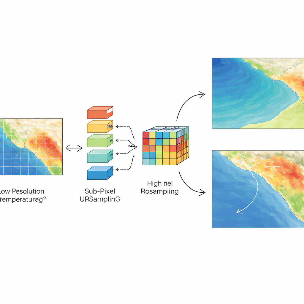
Putting the model through storms
To test robustness, the study also examines extreme weather conditions, focusing on several tropical cyclones over the Pacific and Indian Oceans. Even during these intense, rapidly evolving events, the transferred model continues to add useful fine-scale detail to temperature, wind, pressure, and humidity fields, though with somewhat larger errors than under calm conditions. Regions with simple ocean surfaces fare better than those with complex coastal and inland topography, emphasizing that sharp changes in elevation and land–sea contrast remain a challenge for purely data-driven methods.
What this means for future forecasts
In plain terms, the study demonstrates that an AI model trained to sharpen weather data over one part of the world can be reused over many other regions and for several related variables without starting over each time. This reuse—known as transfer learning—delivers more accurate high-resolution fields than traditional interpolation while saving both time and computing resources. The approach is especially promising for oceanic regions and for variables like near-surface winds. The authors suggest that future work could further improve land performance by feeding the model extra information about terrain and land–sea boundaries. If successful, such methods could make detailed, fast-updating climate and weather products more accessible to forecasters, planners, and researchers worldwide.
Citation: Li, Z., Kong, H., Wong, C. et al. Exploring cross-regional and cross-variable transferability of a ResNet-based super-resolution method for the ERA5 data. Sci Rep 16, 10421 (2026). https://doi.org/10.1038/s41598-026-41002-7
Keywords: climate data, weather forecasting, deep learning, super resolution, transfer learning