Clear Sky Science · en
Slope deformation and failure mechanisms at submerged geoarchaeological sites: physical–numerical modeling
Why a Riverbank Matters to History
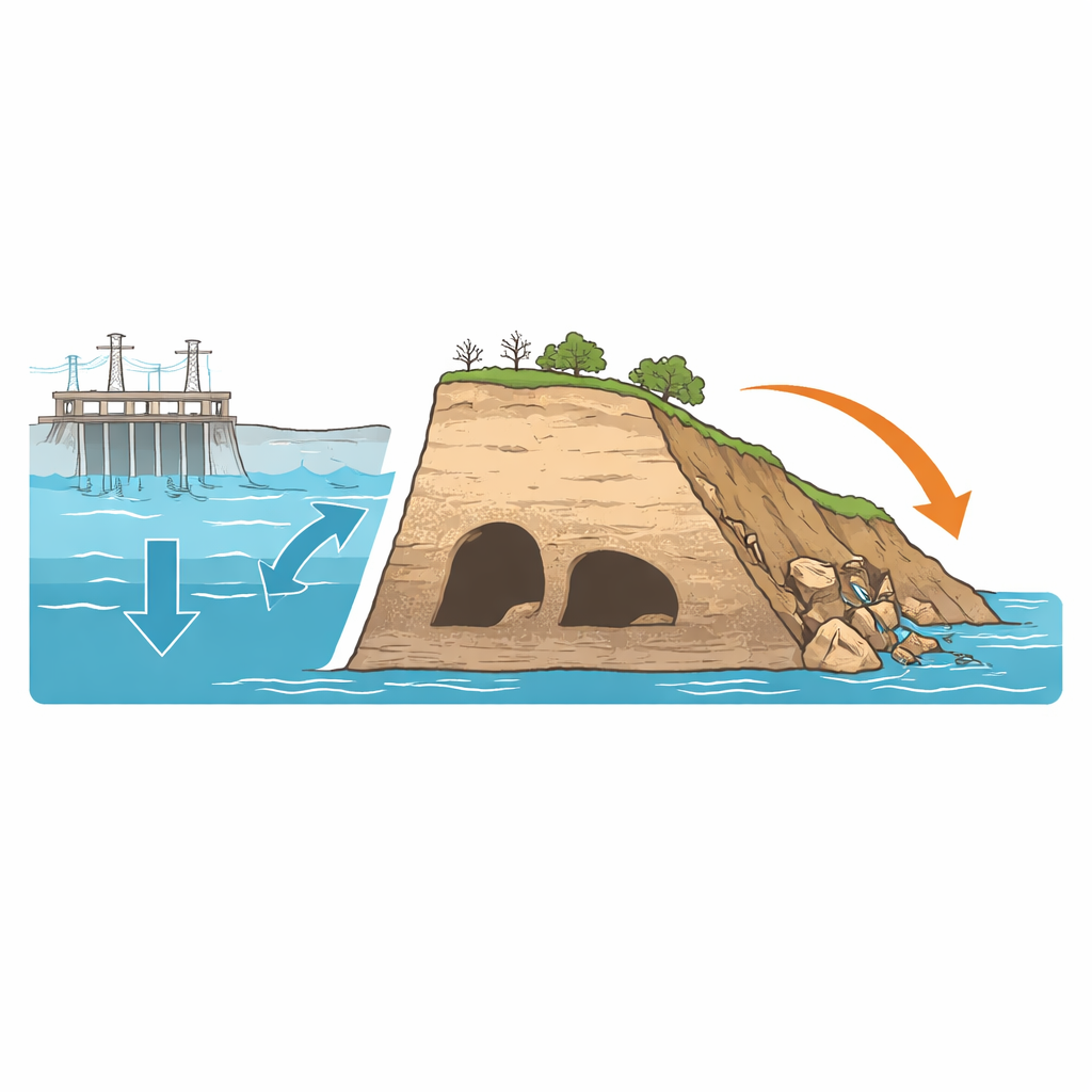
Along the Jinsha River in southwest China lies the Jiaopingdu Heritage Site, where Red Army soldiers once crossed during the Long March. This riverside slope holds caves and soil layers that record both revolutionary history and much older traces of human activity. But a new hydropower reservoir is submerging the site for decades to come. The study explores a simple yet urgent question: how does rising and falling reservoir water slowly weaken the riverbank until the historic caves and the slope around them collapse?
When Reservoirs Meet Fragile Slopes
The authors focus on what happens when a steep riverbank with archaeological caves is flooded and drained again and again as a reservoir operates. Unlike stone temples on dry land, these soil-based cave sites sit inside loose layers of gravel and clay-like material. Once the Wudongde Reservoir reaches its full level, the entire Jiaopingdu slope will lie underwater for long periods. Past research has shown that changing water levels can erode riverbanks, but very little work has examined what that means for irreplaceable cultural sites resting within those banks. Here, the team set out to uncover the step‑by‑step failure process so that engineers and conservators can predict damage and plan protections before the slope gives way.
Building a Riverbank in the Lab
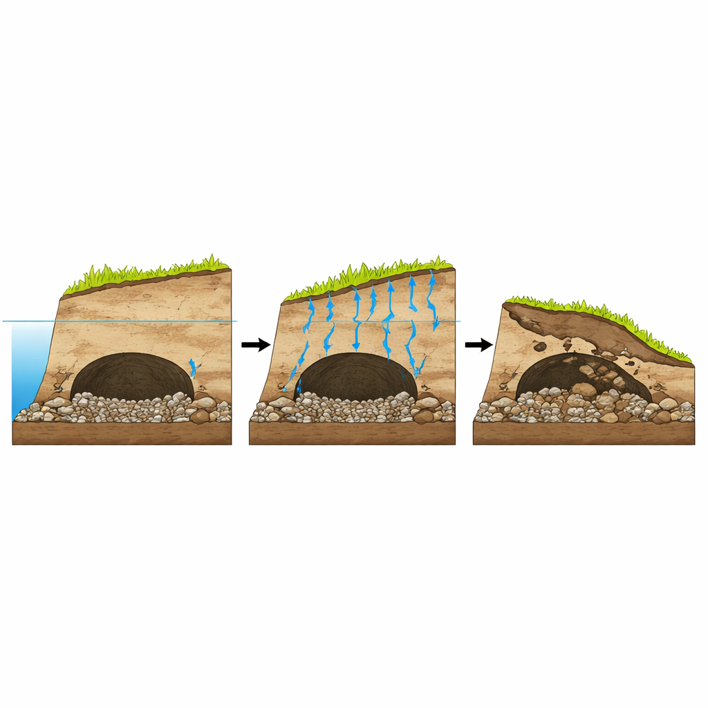
To watch this hidden process unfold, the researchers built a scaled‑down physical model of the real slope in a large transparent box. They reproduced the overall shape of the riverbank, the position of the caves, and the weak gravel layers that run through the site. The soil mix was carefully tuned with added gypsum so that its weight, strength, and ability to let water seep through matched those of the real deposits. They then filled the box with water in controlled cycles to imitate more than a year of reservoir operation in fast‑forward. High‑precision sensors inside the model recorded how pressure in the soil and in the pore water changed, while 3D laser scans and underwater cameras captured the surface and cave deformations before and after flooding.
Watching Caves Fail from the Inside Out
The experiments revealed that the slope does not fail all at once. As the water level rises, both the pressure from the overlying soil and the pressure of water in the pores increase. When the water later drops, the supporting effect of the water falls faster than the pore water pressure inside the slope can dissipate. With each cycle, solid contact between grains weakens: earth pressure slowly declines while pore water pressure creeps upward. This combination steadily reduces the soil’s ability to resist sliding, especially near the underwater cliff at the slope’s toe. In the cave tests, the team compared two shapes: one with a curved, domed roof and one with a flat roof. Under long‑term immersion, the flat‑roofed cave suffered repeated roof collapses that filled its passage, whereas the domed cave mainly lost material at its entrance and kept much of its interior intact. The results show that even simple geometric differences can strongly influence how much damage a cave sustains underwater.
Simulating Hidden Stresses in Three Dimensions
Because laboratory models cannot capture every detail of long‑term behaviour, the researchers also built a three‑dimensional computer model of the slope using specialized software. This numerical model treated the slope as a continuous body where water and soil interact, allowing the team to calculate displacements, zones of high strain, and overall stability under different water levels, rainstorms, and earthquakes. The simulations agreed with the physical tests: the largest movements and highest shear strains clustered at the lower front of the colluvial deposit, in the same region where the model slope collapsed. A particularly weak, poorly cemented gravel layer acted like a sliding plane that controlled where the eventual failure surface would form. The calculated long‑term stability factor of around 0.89 indicates that, under sustained saturation, the slope is already close to a tipping point. When high reservoir levels are combined with heavy rain or moderate earthquakes, the probability of a large landslide affecting the entire cave area rises dramatically.
What This Means for Saving Underwater Heritage
To a non‑specialist, the key message is clear: the danger to underwater heritage at Jiaopingdu is not sudden but gradual, driven by the subtle action of water working its way through fragile soils. Repeated rises and falls of reservoir water slowly eat away at the hidden bonds that hold the slope together, especially around man‑made openings like caves. Domed roofs cope better than flat ones, but both are at risk once the surrounding layers begin to slide. By combining physical and digital models, this study shows how to diagnose which parts of a submerged site are most likely to fail, and under what conditions. That knowledge can guide in situ reinforcement, monitoring, and early‑warning systems, helping to keep the stories written into these riverbanks from literally washing away.
Citation: Zhang, K., Wang, W., Fan, X. et al. Slope deformation and failure mechanisms at submerged geoarchaeological sites: physical–numerical modeling. npj Herit. Sci. 14, 270 (2026). https://doi.org/10.1038/s40494-026-02549-w
Keywords: underwater cultural heritage, reservoir bank stability, slope failure, geoarchaeology, cave collapse