Clear Sky Science · en
Dynamically documenting archaeological excavations based on a portable LiDAR-camera mapping system: the Wuwangdun full-process recording example
Why this ancient tomb matters today
When archaeologists excavate an ancient tomb, they are both uncovering history and destroying a once-in-a-lifetime arrangement of objects and structures. The moment the soil is removed, the original scene is gone forever. This paper shows how a team in China used a fast, portable 3D scanning system to capture the Wuwangdun royal tomb in extraordinary detail at every stage of digging, helping protect fragile artifacts while creating a permanent digital record that future generations can study.
A royal tomb under pressure
The Wuwangdun tomb belongs to the ancient Chu state, a major power in China over 2,000 years ago. Large, well-preserved Chu tombs are rare, yet they hold crucial clues about politics, belief, craftsmanship, and daily life in that era. Modern threats—urban expansion, environmental change, and looting—mean that such sites can be damaged or lost quickly. Archaeologists often must excavate in a hurry, even though excavation permanently alters the site. That tension between urgency and preservation is what drove the search for a better way to record Wuwangdun as work progressed.
Limits of sketches and slow 3D methods
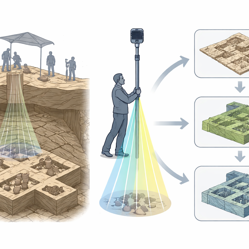
Traditional field recording relies on hand drawings and photographs, which can miss subtle details and cannot fully capture the shape of a complex space. Newer digital 3D methods, such as photogrammetry and drone surveys, can create detailed models—but they often take hours to days to process, and usually require the site to be cleared of people and tools. At Wuwangdun, a metal shelter blocked satellite signals that drones depend on, and the tight, beam‑supported chamber left little room for equipment. The team needed a method that was quick, accurate, and able to work around constant human activity in a crowded, protected dig.
A walk‑through scanner for living excavations
To meet these challenges, the researchers built a portable mapping system that combines a laser scanner (LiDAR) with a 360‑degree camera on a telescopic pole. An operator walks along beam-safe paths while the scanner measures distances tens of thousands of times per second and the camera captures full‑surround images. Within about five minutes they can cover the entire tomb chamber; within roughly half an hour, the data are processed into a detailed 3D representation. Clever mathematics links all scans to a stable coordinate system anchored by fixed reference points, so every day’s dataset lines up with the previous ones to within about a centimeter, even though satellite positioning is unreliable under the metal roof.
Making people disappear while keeping the tomb
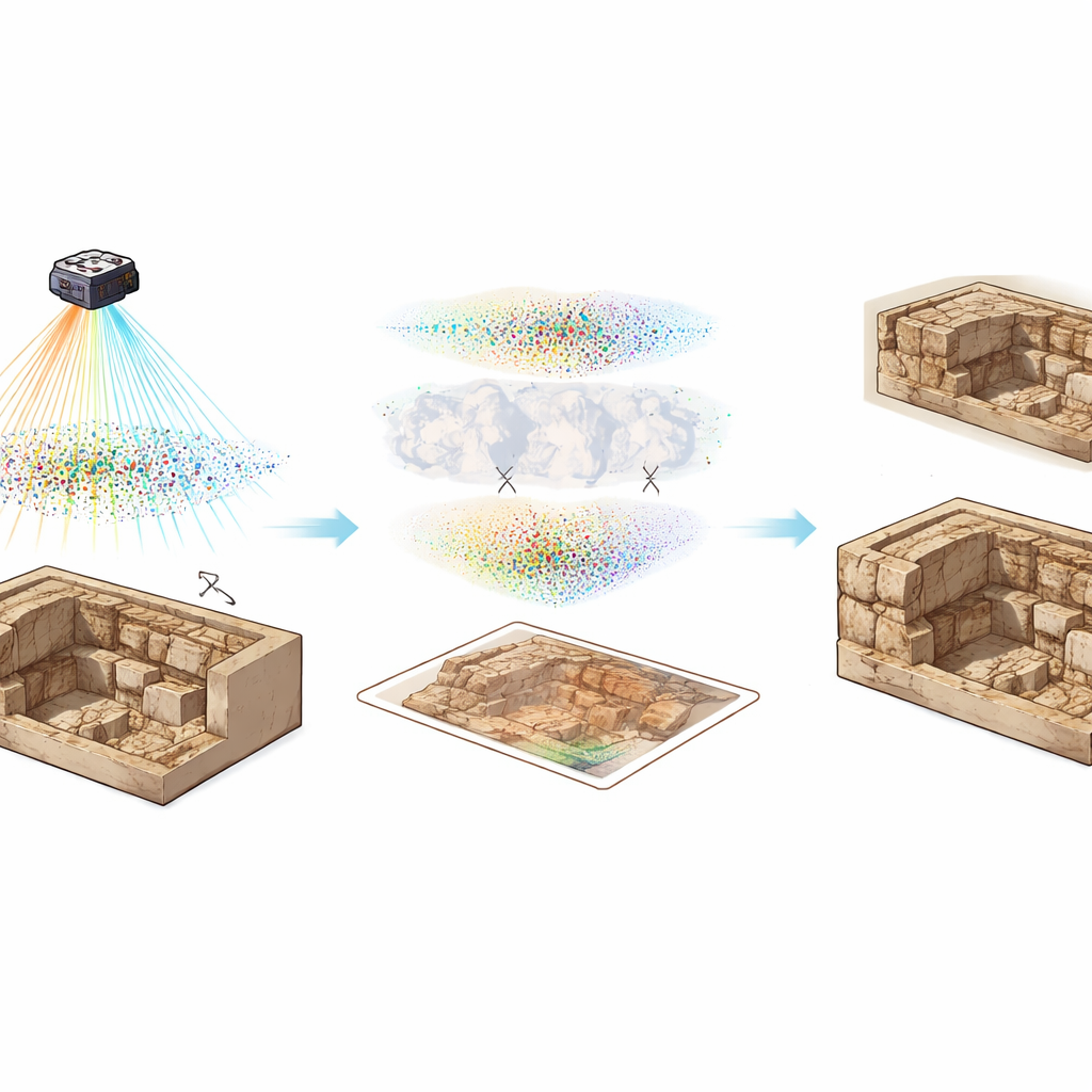
Because excavation is a bustling activity, people, tools, and temporary supports constantly block the view of the tomb surfaces. Instead of forcing everyone to stop work, the team trained an advanced vision model to automatically recognize and mask out moving objects—such as archaeologists, shovels, and plastic tubes—from the images. They first project the panoramic photos into normal-looking views, let the model highlight non‑tomb elements, and then project those masks back onto the original panoramas and matching laser points. The result is a “clean” version of the tomb where artifacts and structure remain, but the workers and equipment that once hid them are digitally removed, reducing errors and gaps in the final models.
From shifting soil to reliable digital twins
Using the synchronized laser and image data, the researchers generate two main products for each stage of excavation: flat, map‑like overhead images (orthophotos) and textured 3D models. As wooden planks are taken away and chambers opened, new scans capture the evolving layout of compartments and the precise positions of artifacts. Orthophotos for all nine chambers reveal differences in size, disturbance, and looting, while the 3D models show how objects relate to one another in depth. Measurements of known points show that positions in these products are accurate to about a centimeter overall, with even finer consistency when comparing scans from different days. In total, the team produced 62 high‑resolution maps and 62 detailed 3D models tracing the full excavation.
What this means for the past and the future
For a lay reader, the key message is simple: this approach turns a fragile, once‑only excavation into a lasting, measurable digital record that can be revisited forever. By rapidly scanning the Wuwangdun tomb with a pole‑mounted laser and panoramic camera—and using smart software to align data over time and digitally erase people and tools—the team captured the site in rich detail without slowing down fieldwork. Their workflow shortens how long artifacts stay exposed, supports careful study away from the site, and opens the door for virtual re‑excavation, teaching, and conservation planning. As similar systems spread, more archaeological digs may be documented this thoroughly, preserving irreplaceable traces of human history even as the earth that once hid them is carefully removed.
Citation: Ou, W., Hu, Q., Wang, S. et al. Dynamically documenting archaeological excavations based on a portable LiDAR-camera mapping system: the Wuwangdun full-process recording example. npj Herit. Sci. 14, 237 (2026). https://doi.org/10.1038/s40494-026-02515-6
Keywords: archaeological 3D recording, LiDAR mapping, digital heritage, tomb excavation, Wuwangdun Chu tomb