Clear Sky Science · en
Mapping pesticide mixtures to cancer risk at the country scale with spatial exposomics
Why this matters for everyday life
Pesticides help protect crops and keep food affordable, but they also raise long-standing worries about cancer. Most safety tests look at one chemical at a time under controlled conditions, which may not reflect what happens to real people living in farming regions. This study zooms out to the scale of an entire country—Peru—to ask a simple but urgent question: do the mixtures of pesticides used in modern agriculture, even those not officially classed as carcinogens, line up with unusual cancer patterns in the real world?
Following pesticides across land, water and air
The researchers first built a detailed map of how 31 widely used pesticides move and linger in the environment. They combined information on rainfall, run-off, soil type, slope of the land and crop locations to model where sprayed chemicals are likely to travel and build up over time. Instead of tracking short bursts of exposure, the model estimates long-term, chronic risk at a very fine scale, down to 100-by-100-metre patches, across almost all of Peru. The results showed large regions of moderate to high risk, especially along the dry Pacific coast and in Andean highlands, where little rain allows pesticides to accumulate, and run-off can carry them into valleys and downstream communities. 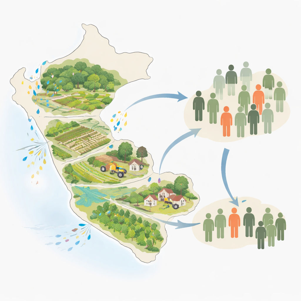
Overlaying cancer maps on pesticide maps
Next, the team turned to Peru’s national cancer registry, which contains more than 150,000 cases recorded over 14 years. Rather than grouping cancers only by organ, they classified them by the developmental "family tree" of the cells they come from—for example, tissues that originate from similar embryonic layers. This lineage-based view makes biological sense, because cells that share a developmental program also share key control switches that can be disrupted in similar ways by outside insults. Using advanced spatial statistics, the researchers looked for districts where high environmental pesticide risk went hand in hand with higher-than-expected cancer rates, and for which this association was unlikely to be due to chance alone.
Hotspots in farming and forest frontiers
This combined mapping revealed 436 cancer hotspots across Peru that were strongly associated with elevated pesticide exposure. Many appeared in rural areas under intense agricultural pressure: irrigated coastal deserts turned into industrial farmland, steep Andean slopes where chemicals easily wash into rivers, and expanding crop frontiers cutting into the Amazon rainforest. These hotspots covered cancers of the gut, lung, skin, female reproductive organs, kidney and other tissues, spanning several developmental lineages. Importantly, some of the most concerning clusters overlapped with territories of Indigenous and peasant communities in central Peru, where people often face both high exposure and limited access to healthcare. The analysis also suggested that climate events like strong El Niño years may further boost exposure by altering how and where pesticides are used.
Zooming in on the liver as an early warning organ
The liver is the body’s main chemical processing plant and a frequent target of carcinogens. In central Peru, the team found a striking cluster of liver cancer, especially in young adults without the usual liver scarring seen elsewhere. To probe what might be happening inside the tissue, they analysed gene activity in tumour and nearby non-tumour liver samples from patients living in pesticide-associated hotspots and compared them with patients from France, Taiwan and Turkey. In the Peruvian non-tumour samples, they detected a gene-expression pattern typical of exposure to non-genotoxic carcinogens—chemicals that do not directly damage DNA but instead unsettle the molecular circuits that keep cells stable. They also saw strong disruption of a set of "master" regulatory genes that normally lock liver cells into their proper identity, suggesting that pesticide mixtures had pushed otherwise normal cells into a fragile, pre-cancerous state. 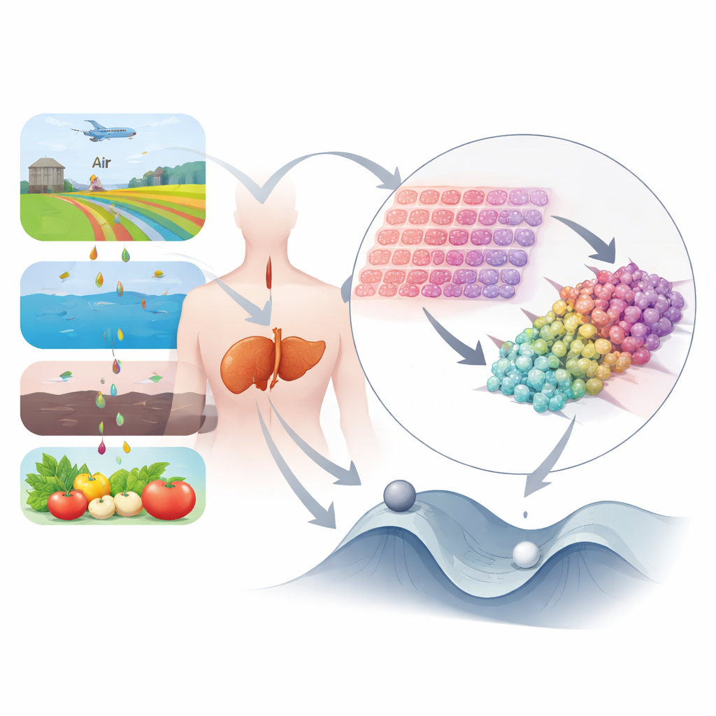
What this means for public health and regulation
Taken together, the study offers rare, converging evidence—from environmental modelling, national cancer statistics and molecular signatures in tissue—that real-world mixtures of pesticides can help nudge human cells along cancerous paths, even when individual chemicals are not labeled as carcinogenic. It shows that how and where people live, work and farm can shape their cancer risk in ways that standard toxicology tests often miss. For lay readers, the core message is that safety rules built around single chemicals and average exposures may underestimate the danger faced by communities living in the shadow of intensive agriculture. The authors argue that we need regulations and farming practices that account for mixtures, long-term build-up, climate swings and social inequality if we are to protect both crops and human health.
Citation: Honles, J., Cerapio, J.P., Monge, C. et al. Mapping pesticide mixtures to cancer risk at the country scale with spatial exposomics. Nat. Health 1, 520–531 (2026). https://doi.org/10.1038/s44360-026-00087-0
Keywords: pesticides, cancer hotspots, environmental health, liver cancer, Peru agriculture