Clear Sky Science · en
Pronounced ocean thermal variability triggered by synoptic forcing in the Eastern Eurasian Arctic
Why storms under Arctic ice matter
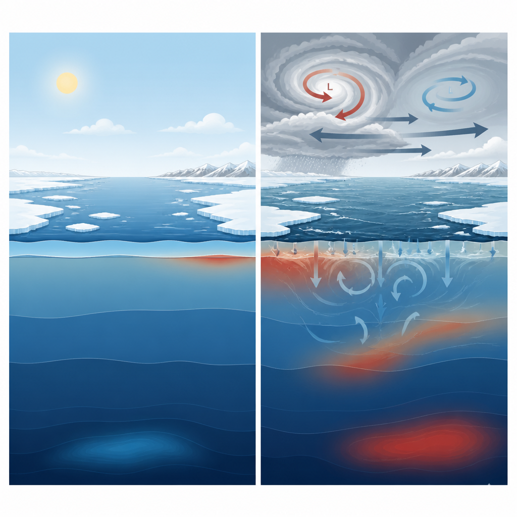
Far from shipping lanes and cities, powerful weather systems are stirring the Arctic Ocean in ways that could reshape regional climate and ecosystems. As sea ice thins and retreats, more open water is exposed to storms, allowing winds and heat to reach deeper into the ocean. This study asks a simple but important question: when strong low and high pressure systems sweep across the Eastern Eurasian Arctic, how do they shuffle heat up and down in the ocean, and how does that behavior change between summer and winter?
Storm tracks over a changing ice edge
The researchers focus on the marginal ice zone, the shifting boundary where solid pack ice gives way to open water. In the Eastern Eurasian Arctic, this strip of ocean has become a hotspot of rapid change, with large swings in sea ice cover and frequent storms. Using detailed weather records, the team identifies dozens of strong low pressure systems (cyclones) and high pressure systems (anticyclones) that passed over the region during 2016. Each of these synoptic events lasted several days, and together they influenced the area for as much as two thirds of the year, repeatedly disturbing the ocean surface.
A high resolution look beneath the waves
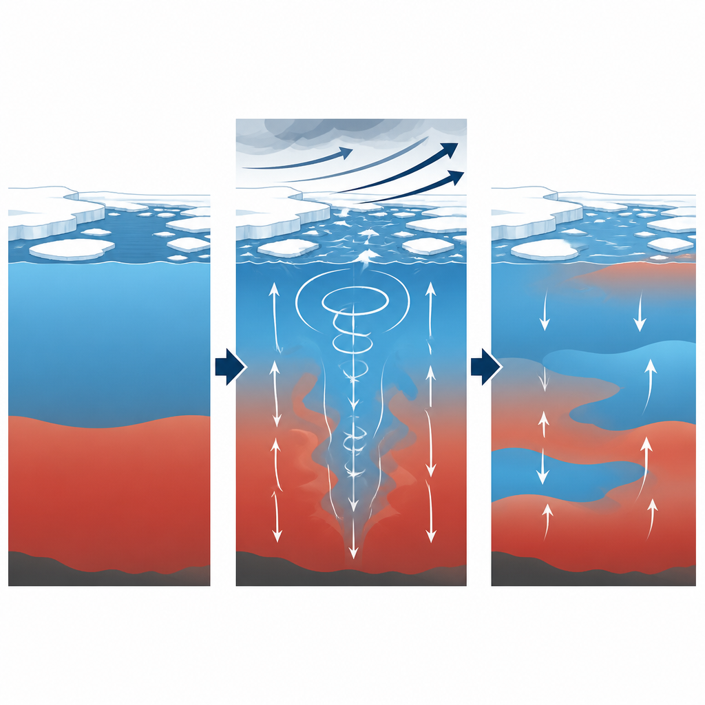
Direct measurements under Arctic ice are sparse, so the team turns to a powerful numerical tool: a global ocean and sea ice model that represents the Arctic at one kilometer resolution. This fine grid allows the model to capture narrow cracks in the ice, small whirls in the ocean, and sharp changes in mixed layer depth that coarser models would blur out. The scientists track how heat stored in the upper 50 meters and in deeper layers down to 200 meters changes from day to day. By applying an extreme event detection method, they flag unusual warming or cooling spikes that stand out from the typical seasonal cycle.
Summer storms cool the surface but warm below
During summer and early autumn, when the ice edge retreats and exposes more open water, intense cyclones have a striking effect on ocean temperature. Strong winds increase mixing and draw heat from the surface into the air, rapidly cooling the shallow mixed layer. At the same time, the model shows warming patches just below this layer, around 100 meters depth. This pattern reveals that while storms remove heat from the surface, they also push and pull water vertically, shifting heat downward into the ocean interior. In contrast, quieter high pressure periods allow the sun and atmosphere to gently warm the upper ocean, especially when conditions are relatively calm and the ice cover is lower.
Winter storms reach deeper through vertical motions
In winter and spring, thick ice covers much of the region and the surface ocean cools and grows saltier, creating a denser cap at the top. The mixed layer sits deeper than in summer but remains fairly steady. Even then, synoptic systems still leave a clear mark. Strong winds over the ice produce small openings and rough ice motion, which in turn drive subtle but persistent vertical flows in the water column. The model links these vertical motions to changes in stored potential energy in the stratified ocean and to a process called baroclinic instability, which converts that stored energy into moving water. The result is pronounced warming and cooling events around 100 meters depth that occur in step with the timing of storms, even though the surface appears relatively insulated by ice.
Linked air, ice, and ocean responses
Across the full year, the study finds that changes in upper ocean heat content closely follow shifts in surface heat exchange, while deeper heat changes track the strength of storm driven vertical motions. The seasonal evolution of stratification, set by melting and freezing of sea ice, controls how efficiently winds can stir the ocean and how far their influence penetrates downward. In summer and autumn, when the upper ocean is strongly layered and stores more potential energy, storms are especially effective at redistributing heat vertically. In winter and spring, the same winds still matter, but their impact is focused more on interior depths rather than on the surface layer.
What this means for the Arctic future
For a general reader, the main message is that Arctic storms do far more than break up sea ice or roughen the surface. As sea ice continues to retreat and the marginal ice zone widens, these weather systems are becoming key players in how heat is shuffled between the atmosphere, surface waters, and the ocean interior. This vertical reshaping of temperature affects how much heat is available to melt ice, how marine organisms experience rapid thermal swings, and how the Arctic Ocean exchanges energy with the rest of the climate system. The study provides a physical framework showing that the timing and strength of storms, together with the evolving ice cover, jointly control when and where strong ocean temperature surprises are most likely to occur.
Citation: Liu, C., Müller, V., Shu, Q. et al. Pronounced ocean thermal variability triggered by synoptic forcing in the Eastern Eurasian Arctic. Commun Earth Environ 7, 455 (2026). https://doi.org/10.1038/s43247-026-03443-w
Keywords: Arctic storms, sea ice retreat, ocean heat content, marginal ice zone, vertical mixing