Clear Sky Science · en
Machine learning driven reservoir property modeling of the AEB-3E reservoir in the Berenice field Egypt
Why this subsurface story matters
Oil and gas may seem like a thing of the past, yet the world still relies heavily on them. How we find and manage these underground resources affects not only energy security but also how much new drilling is really needed. This study looks at a field in Egypt and asks a simple question with a high-tech twist: can modern machine learning help us build a clearer picture of hidden rock layers using very limited data, so that companies can make smarter, less wasteful choices?
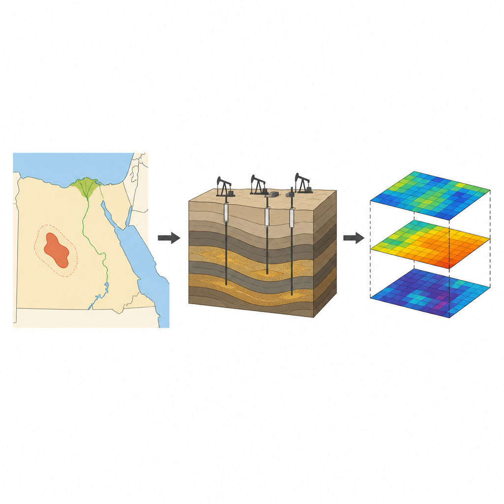
The hidden landscape under the desert
Deep below Egypt’s Western Desert, the Berenice oil field holds a stack of rock layers formed in ancient rivers and shallow seas. The particular layer of interest, called AEB-3E, is made of sandstones and shales arranged in a complex pattern, sliced and shifted by faults. These breaks in the rock can trap fluids in separate compartments, so one well can look promising while a nearby one does not. That patchiness makes it hard to predict how much oil or water sits between the few existing wells, and how easily fluids might flow through the rock.
Clues from wells and seismic echoes
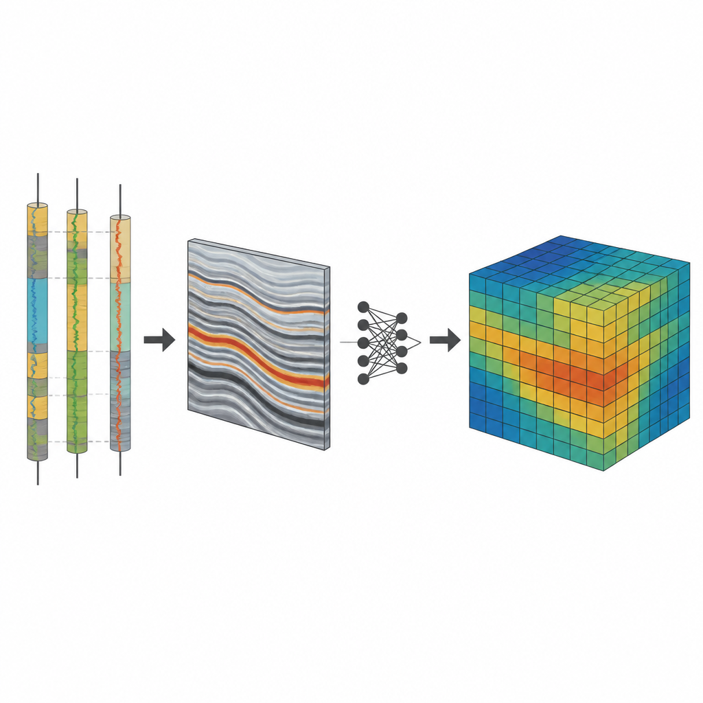
The researchers started with just four wells, each recording how different rock properties change with depth: radioactivity, density, sound speed, how easily electricity passes, and how much hydrogen is present. From these measurements they calculated three key traits that control how useful the rock is as a reservoir: how much clay-rich material it contains, how much empty space is available to store fluids, and how much of that space is filled with water rather than hydrocarbons. They then matched these well profiles to a three-dimensional grid and combined them with 3D seismic data, which act like medical scans of the subsurface, revealing structures and subtle changes between wells.
Letting an ensemble of models learn the patterns
Instead of relying only on traditional statistical methods, which assume fairly smooth and predictable changes in space, the team used a workflow called EMBER. It trains many decision-tree models at once, letting them learn how combinations of seismic patterns and well measurements relate to rock quality at known locations. At the same time, it borrows ideas from geostatistics to keep the results geologically reasonable, maintaining continuity along layers and across the field. For every small block in the 3D grid, the method does not just give a single answer but a full range of possible values, describing both the best estimate and how uncertain that estimate might be.
What the models say about this reservoir
The resulting maps paint a picture of the AEB-3E layer as mostly clean sandstone with relatively low clay content and fair to good space for fluids. Zones with less clay tend to align with higher storage capacity and lower water content, highlighting areas that are more attractive for production. Cross sections through the model show that these favorable zones are laterally continuous in places but also shaped by faults and subtle changes in the original river and shoreline environments. The simulations further indicate that uncertainty is generally low to moderate, but grows near faults and in regions far from any well, where the model must lean more heavily on seismic patterns alone.
Benefits, limits, and what it means in practice
The study suggests that combining machine learning with seismic and well data can speed up reservoir modeling and reduce the amount of manual trial and error, even when only a handful of wells are available. In the Berenice field, the approach identifies a southwest area that seems especially promising yet remains undrilled, offering a focused target for future work. At the same time, the authors stress that their conclusions are preliminary: with just four wells, any prediction away from these data points must be treated cautiously and checked against new wells or production information. For readers, the takeaway is that smarter digital tools can help energy companies use existing data more fully, narrow down where new drilling is most justified, and better understand the uncertainties that still remain deep beneath our feet.
Citation: Eid, A.M., Mabrouk, W.M., Amer, M. et al. Machine learning driven reservoir property modeling of the AEB-3E reservoir in the Berenice field Egypt. Sci Rep 16, 16131 (2026). https://doi.org/10.1038/s41598-026-53328-3
Keywords: reservoir modeling, machine learning, seismic data, Western Desert Egypt, petrophysical properties