Clear Sky Science · en
Integrated multidisciplinary approach for reducing uncertainty in reservoir characterization of the Bahariya Formation, Berenice Field, Egypt
Why this desert story matters
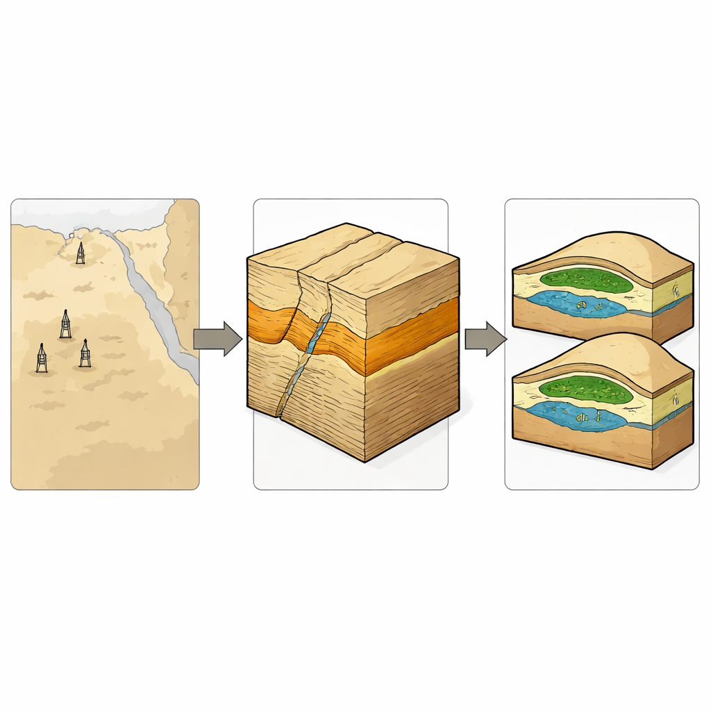
Beneath Egypt’s Western Desert lies a maze of ancient sandstones and buried faults that quietly supply part of the world’s oil. Deciding where to drill new wells in this hidden landscape is risky and expensive, especially when the rocks are complex and data are limited. This paper follows a team of geoscientists as they combine several types of subsurface information—seismic images, well measurements, and computer models—to build a clearer picture of one such reservoir, the Bahariya Formation in the Berenice Field. Their goal is to cut down uncertainty, avoid dry wells, and make better use of an important national energy resource.
Looking under the desert floor
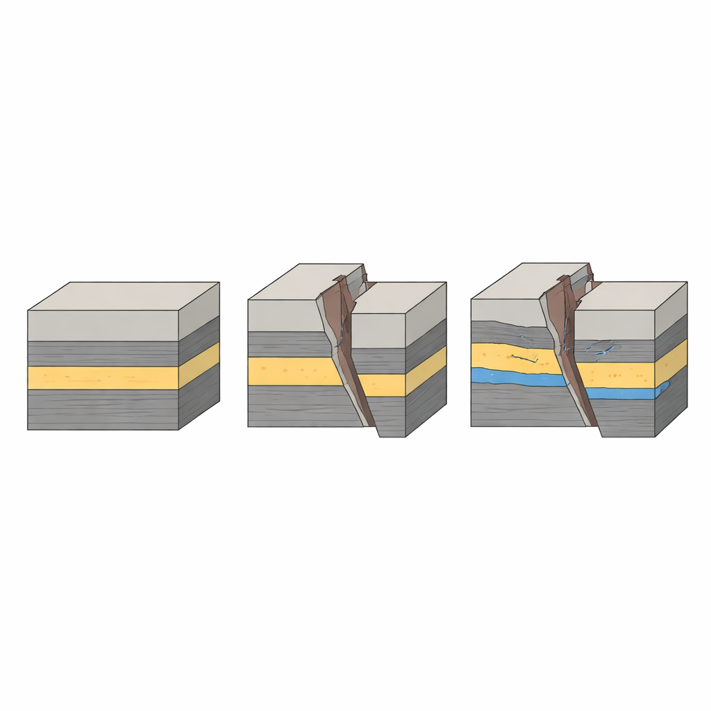
The study focuses on the Bahariya Formation, a package of sand-rich rocks buried deep beneath the northeastern part of the Faghur Basin in Egypt’s Western Desert. Over millions of years, shifting tectonic forces stretched and squeezed this area, breaking the crust into tilted blocks separated by long, steep faults. These structures now act as potential traps for oil and gas migrating upward from deeper source rocks. To map this hidden architecture, the team analyzed twenty seismic profiles—acoustic "X‑ray" slices of the subsurface—along with data from several wells that penetrate the Bahariya sands. By tying the well data to the seismic images using synthetic seismograms, they could match rock layers seen in the boreholes to reflections seen on seismic sections, sharpening their depth estimates.
Reading subtle signals in the seismic
Beyond simple structural mapping, the researchers extracted additional clues from the seismic data using “attributes” that highlight patterns often missed by the naked eye. Measures of variance, local dip, and azimuth sharpened the view of fault trends and subtle folds, while amplitude and phase changes flagged spots where rock properties or fluid content differ from their surroundings. Together, these tools revealed a set of northwest–southeast trending normal faults and gently dipping layers that form three‑way and four‑way closures—bowl‑shaped structures that can hold hydrocarbons if properly sealed. Some of the strongest seismic anomalies sit on these structural highs, hinting at zones where oil may have pooled.
What the wells say about the rocks
Seismic images alone cannot reveal how easily fluids flow through the reservoir, so the team turned to well logs that record how rocks respond to natural radioactivity, electrical current, and neutron and density probes. From these readings they estimated shale content, porosity (how much empty space the rocks contain), water saturation, and permeability (how connected the pores are). In the key upper Bahariya units, they found relatively high porosity around 26–27% and low water saturation near 24–25%, values that point to good-quality oil-bearing sandstones. However, shale content varies strongly from place to place, meaning some zones act as better conduits than others. By applying several standard permeability formulas and favoring the more physically based Kozeny–Carman approach, they built a more realistic picture of how fluids might move through the reservoir.
Building a 3D picture and testing the seals
To bring all of this information together, the authors constructed a three‑dimensional geological model that weaves seismic surfaces, faults, and well‑derived rock properties into a single framework. This model shows two main structural closures within the Bahariya sands, one near well Berenice‑29X and another near Berenice‑1X, where porosity is higher, shale content is lower, and modeled permeability is favorable. The team also assessed whether the faults themselves help trap hydrocarbons or leak them away, using a measure called the shale gouge ratio to estimate how much clay is smeared along each fault plane. Most of the Bahariya faults appear to be tight, with very low transmissibility, effectively acting as barriers that compartmentalize the reservoir and help hold hydrocarbons in place.
From rock model to recoverable barrels
With the 3D model in hand, the researchers calculated how much oil the Bahariya Formation might hold in different blocks of the field and how much could realistically be produced. They combined reservoir area, thickness, porosity, and hydrocarbon saturation with a recovery factor and oil expansion behavior to estimate stock‑tank oil initially in place and recoverable reserves. To capture the inherent uncertainty, they ran a Monte Carlo simulation, repeatedly varying key inputs such as porosity, water saturation, and net‑to‑gross sand thickness. The resulting range of outcomes shows that their detailed model‑based estimates are broadly consistent with probabilistic mid‑case values, lending confidence to predictions of roughly a few million barrels of recoverable oil in the main closures and additional potential in thinner zones.
What it all means for future drilling
For non‑specialists, the core message is that looking for oil is far more than guessing at promising spots on a map. By carefully stitching together seismic images, well‑bore measurements, and physics‑based models, this study reduces the unknowns in a structurally complex reservoir. It pinpoints where good‑quality sands coincide with sealed structural highs, highlights leads most worth testing with new wells, and quantifies the uncertainty around each volume estimate. The approach offers a practical roadmap for making more informed, lower‑risk decisions in the Berenice Field and in similar hidden reservoirs around the world.
Citation: Fawzy, M.N., Salem, T.M., Helal, A.N. et al. Integrated multidisciplinary approach for reducing uncertainty in reservoir characterization of the Bahariya Formation, Berenice Field, Egypt. Sci Rep 16, 13884 (2026). https://doi.org/10.1038/s41598-026-47694-1
Keywords: Western Desert Egypt, Bahariya Formation, reservoir modeling, fault-controlled traps, seismic petrophysical integration