Clear Sky Science · en
An explainable GeoAI framework for spatial assessment of wildfire susceptibility in the Upper Ravi sub-basin, Indian Himalaya
Why fires in the Himalaya matter to all of us
Forest fires are often pictured in dry western landscapes, yet some of the fastest-changing fire risks are now in the Himalayan mountains of India. These forests store water, cool the climate, and support hundreds of thousands of people. When they burn, homes, wildlife, and even distant snow and rivers are affected. This study looks at one such region—the Upper Ravi sub-basin in Himachal Pradesh—and shows how modern mapping tools and artificial intelligence can reveal where future wildfires are most likely to start and spread, giving communities a chance to act before disaster strikes. 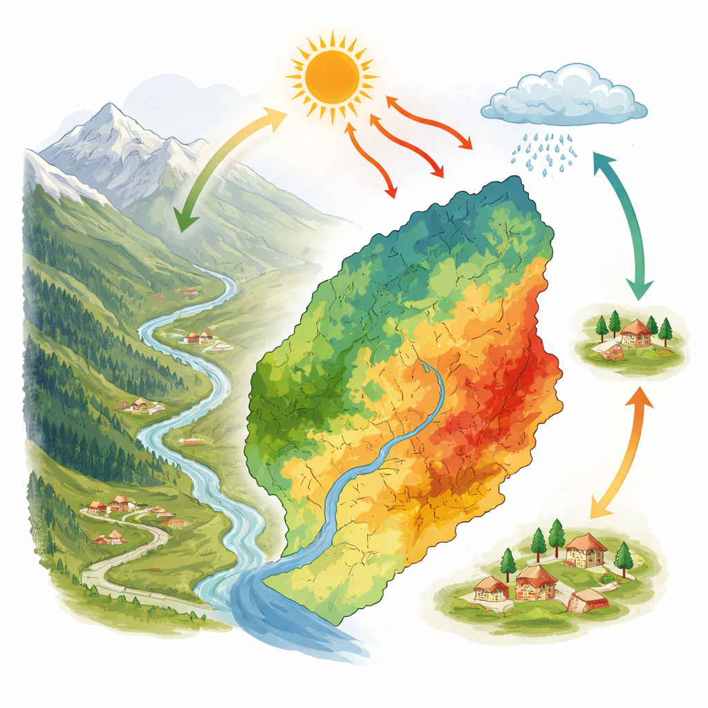
A mountain valley under growing fire pressure
The Upper Ravi sub-basin is a steep Himalayan landscape stretching from subtropical foothills to near-arctic heights. Its forests are increasingly stressed by hotter temperatures, longer dry spells, and human activities such as road building, tourism, and expanding villages. Pine needles that pile up on the forest floor form a highly flammable carpet during the dry season from February to June. In recent years, Himachal Pradesh has recorded some of the highest numbers of wildfire incidents in India, with fires threatening both remote slopes and settled valleys. Against this backdrop, the authors set out to build a detailed “susceptibility map” showing which parts of the basin are more or less likely to experience wildfires.
Turning satellites and maps into a fire risk picture
To create this map, the team combined many different sources of information. Satellite data provided details on land cover, vegetation health, rainfall, temperature, soil moisture, and wind. Elevation models captured how steep and rugged the terrain is, while open mapping projects supplied the locations of roads, villages, religious sites, and tourist spots. From NASA’s fire detection system, they compiled more than 20 years of past fire locations. Altogether, they selected sixteen “conditioning factors” that might help or hinder fires—from slope angle and wind speed to distance from villages and roads. Each point on the landscape was described by these factors and labeled as either burned or unburned in the historical record, producing the raw material for computer learning.
Asking a team of algorithms to agree
Instead of relying on a single statistical model, the researchers trained several advanced machine learning methods that specialize in finding patterns in complex data. These included popular tree-based approaches such as Random Forest, XGBoost, LightGBM, and CatBoost. Finally, they combined them in a “stacking” approach, where a simple model learns how best to mix the strengths of all four. Tested on independent data, every method could distinguish fire-prone from safer areas quite well, but the stacked model performed best, correctly separating them most of the time. Its success suggests that a committee of diverse algorithms can better capture the tangled influences of climate, terrain, and people on wildfire behavior in the mountains.
Peering inside the black box of artificial intelligence
Powerful as they are, such models are often criticized for being opaque. To address this, the authors used an explainability technique that estimates how much each factor pushes the prediction toward higher or lower fire risk. The results highlighted a clear group of leading drivers. Warmer air temperatures and drier soils raised susceptibility, while higher soil moisture and relative humidity suppressed it. Places closer to villages showed greater risk, pointing to the role of human ignition. Steep slopes and certain hillside orientations also mattered, because they influence how quickly fuels dry and how flames climb. In short, the model echoed physical intuition: hot, dry, steep terrain near people is where trouble is most likely to start. 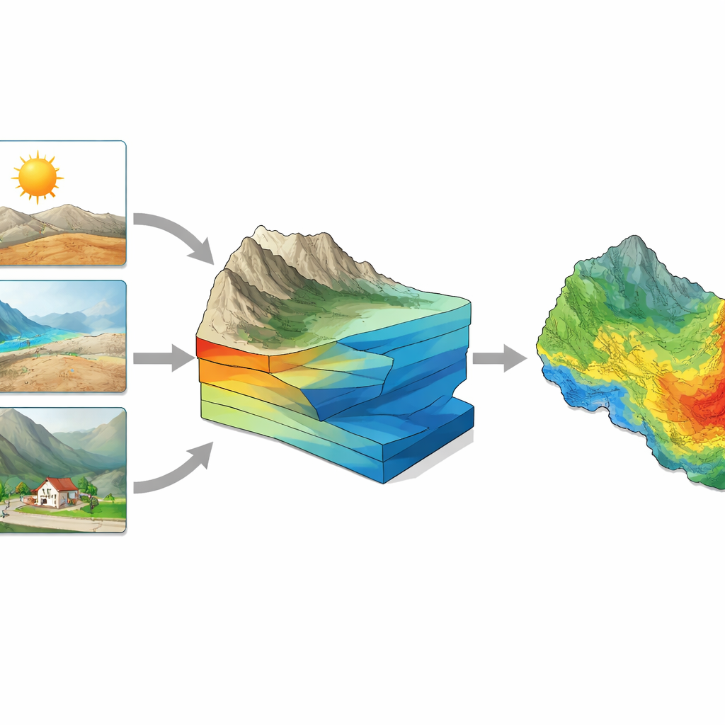
Checking how stable the answers really are
Any model is only as trustworthy as its inputs, which can be uncertain because of measurement errors or shifting weather patterns. To test stability, the researchers repeatedly “jiggled” their input data within a realistic range and reran the model thousands of times, a technique known as Monte Carlo simulation. They also applied a global sensitivity method that measures how much each factor—alone and in combination with others—contributes to changes in predicted risk. Both checks pointed to soil moisture and temperature as the most influential ingredients, followed by rainfall and humidity. Even when the inputs were nudged, the model’s skill dropped only slightly, suggesting that its main conclusions are robust rather than fragile coincidences.
A clearer view of where fires may strike next
By layering all these insights, the study concludes that about one-fifth of the Upper Ravi sub-basin falls into high or very high wildfire susceptibility, mainly on steep, dry slopes near roads and settlements. For local officials, this map is more than an academic product: it highlights where to focus early warning, fuel management, and public awareness efforts. For a lay reader, the key message is straightforward. In this Himalayan valley, the combination of heat, dryness, and human presence is quietly priming certain hillsides to burn. Tools that blend satellites, smart algorithms, and clear explanations can help turn that hidden pattern into practical action—before the next severe fire season arrives.
Citation: Suheb, Nawazuzzoha, M., Ali, M.S. et al. An explainable GeoAI framework for spatial assessment of wildfire susceptibility in the Upper Ravi sub-basin, Indian Himalaya. Sci Rep 16, 11662 (2026). https://doi.org/10.1038/s41598-026-46924-w
Keywords: wildfire susceptibility, Himalayan forests, machine learning, soil moisture, climate and fire