Clear Sky Science · en
An integrated, simulation-based framework linking satellite fire patterns and wireless sensor network planning in Tunisia
Why smarter fire watching matters
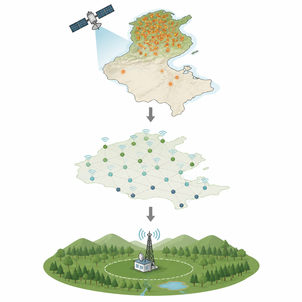
Wildfires threaten lives, forests, and rural communities around the Mediterranean, and North Africa is no exception. In Tunisia, fires keep flaring up in the same forested regions, yet ground monitoring is sparse and hard to maintain. This study shows how information from space can be turned into practical guidance for where to place ground sensors, aiming to watch risky areas more closely while using less energy and equipment.
Seeing fire patterns from space
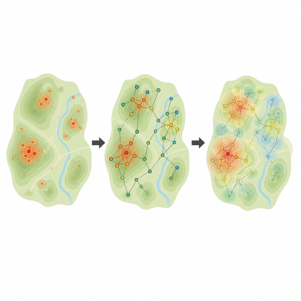
The researchers start by looking at several years of fire detections from NASA satellites over Tunisia. These satellites spot the heat from active fires at night and day, giving a map of where fires actually occurred between 2022 and 2025. Instead of treating these as isolated points, the team uses different clustering methods to reveal corridors where fires tend to reappear, especially in the humid, forested northwest. These recurring hotspots suggest that some areas are structurally more fire prone than others, likely because of terrain, fuel, and human activity, even though those drivers are not modeled directly.
Turning patterns into risk maps
Next, the study asks a practical question: given what we know from past fires, which places are most likely to ignite in the future? To answer this, the authors train several statistical and machine learning models using information that would be available before a fire starts, such as location, time of year and day, and basic satellite metadata. They carefully test these models in a way that keeps neighboring areas separate, to avoid inflating performance just because nearby points look alike. A type of model called Random Forest performs best overall, producing smooth maps that highlight high ignition likelihood in the same northwest corridors already seen in the raw satellite data.
Exploring short term fire behavior
The team also experiments with a deep learning model that looks at sequences of daily satellite images to see whether it can anticipate where fires might appear the next day. This model, known as ConvLSTM, is designed to handle both space and time, learning how patterns move and change. Under strict year by year testing, it does a little better than simple baselines that just repeat yesterday’s pattern or use long term averages, but the gains are modest. The authors treat this as a proof of concept: satellite fire records alone carry some short term signal, but reliable day ahead forecasting will likely require adding weather, vegetation, and other environmental data.
Designing smarter sensor networks
The most applied part of the work uses the risk information to plan where to place wireless sensor nodes in the forest. These small devices can detect heat or smoke and send alerts, but their batteries and communication range are limited, so layout matters. The study compares a simple even grid of sensors with layouts that follow the fire hotspots and with an optimized layout found by a swarm based search method. In computer simulations, hotspot informed layouts shorten the typical distance between neighboring nodes and cut estimated communication energy by roughly one third compared with the uniform grid, while also covering more of the historically risky locations.
What this means for fire prone regions
This work does not claim to be a ready made early warning system, and its results come from controlled simulations rather than field trials. Still, it offers a clear recipe for moving from satellite fire data to concrete decisions about where to place sensors on the ground. For Tunisia and similar Mediterranean landscapes, the study shows that paying attention to where fires have actually burned in the past can help design leaner, more focused monitoring networks that watch dangerous corridors more closely while saving energy and hardware. Future steps, the authors note, will need to bring in weather and vegetation data and test these layouts in real forests.
Citation: Mejri, I., Zrelli, A. & Ezzedine, T. An integrated, simulation-based framework linking satellite fire patterns and wireless sensor network planning in Tunisia. Sci Rep 16, 16184 (2026). https://doi.org/10.1038/s41598-026-46885-0
Keywords: wildfire monitoring, satellite data, wireless sensor networks, Tunisia forests, fire risk mapping