Clear Sky Science · en
Research on the problem of spatial heterogeneity in row data and generalization capability for landslide susceptibility assessment using the physics-constrained U-net model
Why this matters
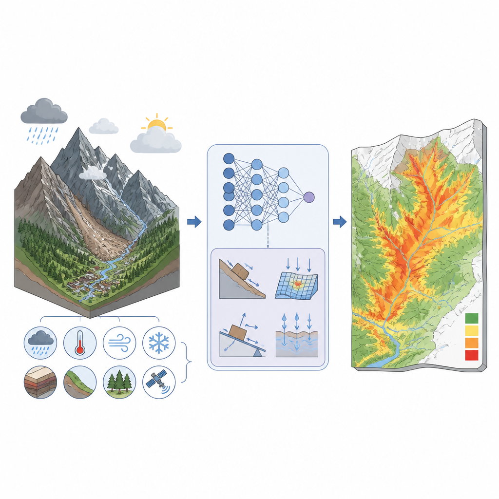
Landslides threaten roads, towns, and infrastructure in many mountain regions, especially as climate change brings heavier rain. This study explores a new way to map where landslides are most likely to occur across a vast area of southeastern Tibet, using an artificial intelligence model that is guided by real-world physics. The approach aims to give planners and emergency managers sharper, more reliable maps that reflect both the rugged landscape and changing weather.
Seeing danger in the mountains
The researchers focus on a huge high-altitude region that includes Lhasa, Nyingchi, Qamdo, and surrounding areas. Here, steep slopes, powerful rivers, active faults, and harsh weather combine to make landslides frequent and varied. Traditional methods rely heavily on past records and simple statistics, which can miss important patterns, especially where data are incomplete. At the same time, common machine learning models, though more flexible, tend to blur local details and struggle when the landscape changes from place to place. For a region as complex as southeastern Tibet, these limits can make risk maps too coarse for real-world decisions.
What the new model does differently
To address these problems, the authors build a physics-constrained U-Net model, a type of deep learning system that can classify every pixel in a map instead of just large blocks. They feed the model ten key factors that shape landslides, including slope angle, curvature, slope direction, landform type, rock type, distance to rivers and faults, rainfall, temperature, and seismic intensity. Unlike many neural networks, this one is designed to preserve fine spatial details so that the final susceptibility map keeps the original high resolution of 30 meters. That higher detail allows the model to highlight hazardous slopes and valleys rather than averaging risk over broad patches of terrain.
Bringing physics into artificial intelligence
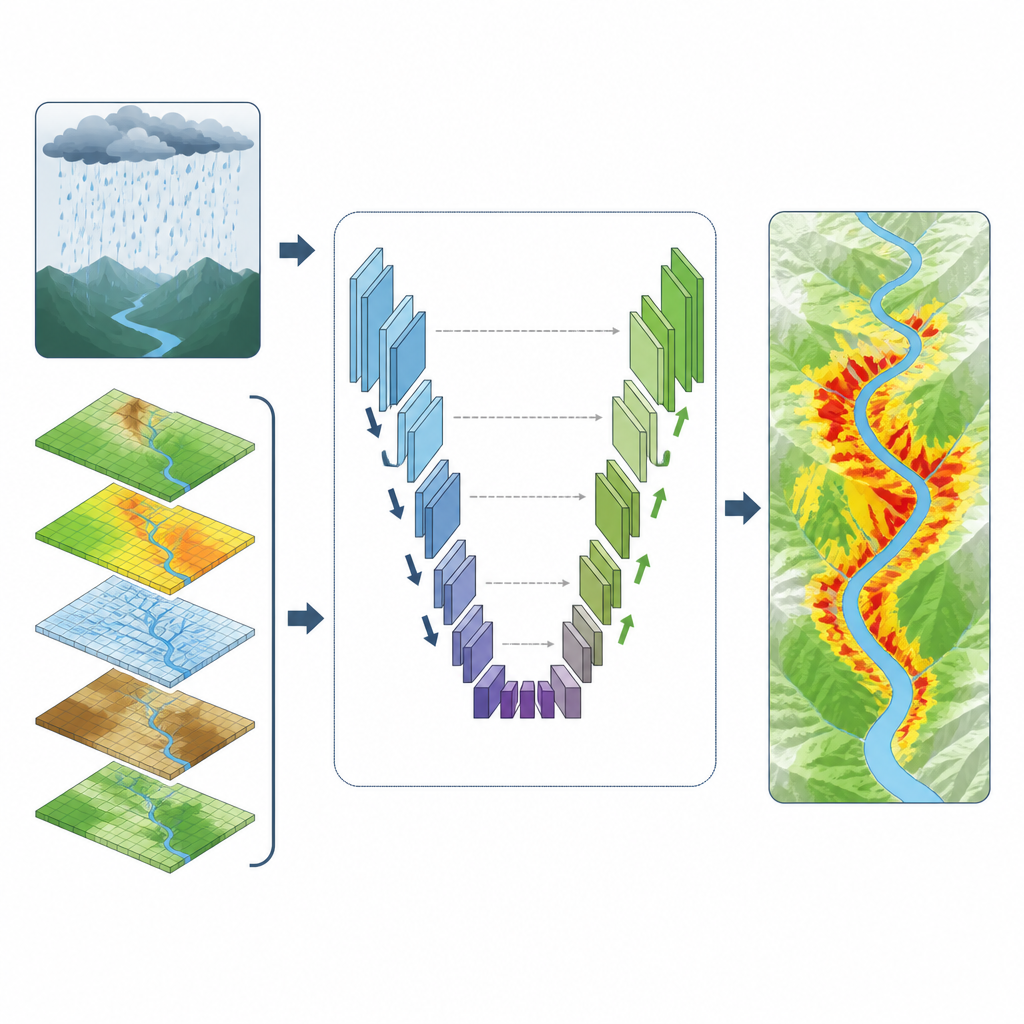
A major innovation is the way the model is taught to respect basic physical behavior of slopes under heavy rain. In mountain regions, intense rainfall over several days can saturate soil and trigger failures, and many early warning systems use a seven day rainfall window. The authors embed a simple safety factor based on seven day rainfall and regional rainfall thresholds into the model’s loss function, which is the measure it tries to minimize while learning. When the model predicts low landslide probability in an area where rainfall-based conditions signal high danger, it receives an extra penalty. At the same time, the training process assigns more weight to scarce landslide pixels than to abundant stable pixels, helping the network learn from both types of examples despite the strong imbalance in the data.
How well it works in different places
The team then tests the physics-constrained U-Net against two widely used deep learning models, a backpropagation neural network and a residual neural network. They compare not only overall accuracy but also how well each model performs in five separate landslide hot spots that differ in geology, river shape, and climate. While the competing models do well in some areas and poorly in others, the physics-constrained U-Net delivers consistently high scores across all five regions. It also produces susceptibility maps that closely match the known distribution of past landslides, with more disaster points falling in zones labeled as very high risk and fewer in areas labeled as very low risk. Crucially, it does this while keeping the full 30 meter spatial resolution, revealing detailed patterns along river bends, fault zones, and steep valley walls.
What this means for risk planning
In plain terms, the study shows that an AI model that “knows” some basic physics and pays special attention to rare but important landslide events can provide sharper and more trustworthy risk maps over large, complex regions. The physics-constrained U-Net not only slightly improves standard accuracy measures but also handles patchy data, varying landscape conditions, and fine spatial detail better than the other tested models. While the authors note that field surveys and better input data would further enhance results, their work suggests a practical path toward high resolution landslide susceptibility maps that can be transferred between different mountain areas, supporting safer development and more effective disaster preparedness.
Citation: Zhang, H., Deng, H. Research on the problem of spatial heterogeneity in row data and generalization capability for landslide susceptibility assessment using the physics-constrained U-net model. Sci Rep 16, 15901 (2026). https://doi.org/10.1038/s41598-026-46873-4
Keywords: landslide susceptibility, deep learning, U-Net model, spatial heterogeneity, Tibetan Plateau