Clear Sky Science · en
Convolutional neural network approach for accelerated traffic noise mapping
Why city noise matters to everyday life
City dwellers are surrounded by traffic noise that can disturb sleep, raise stress, and affect mental health. Governments try to manage this hidden pollution using detailed “noise maps” that show how loud different streets and neighborhoods are. But making these maps with traditional computer models is so slow and costly that they are usually updated only every few years. This study explores how a type of artificial intelligence called a convolutional neural network can speed up traffic noise mapping while keeping it accurate enough for real-world planning and health research.
From busy streets to pictures a computer can read
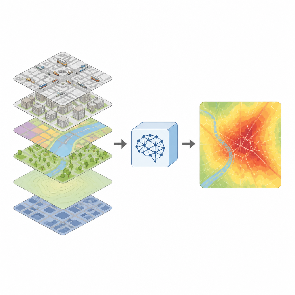
The authors start from the way noise maps are usually made. Standard tools take detailed information about roads, traffic volume, vehicle types, building shapes, and barriers, then simulate how sound travels and bounces through a city. This process is very precise but painfully slow, especially when millions of locations must be calculated. Instead of replacing these physical simulations outright, the team uses them as teachers. They convert the same map information into image-like layers and pair each “picture” with the simulated noise level at one location. These pairs then become training data for an image-based AI model that learns to predict noise directly from the map-style images.
How the new model sees the city
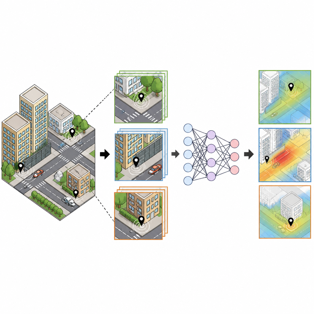
The researchers design several image formats to capture what matters for traffic noise. Each target location is surrounded by a square kilometer of city, cut into a grid. In these images, pixel values encode things like building height, traffic density, and road speed. A key innovation is adding a high-detail central patch that zooms in on the 100 meters closest to the listening point, where nearby roads and walls strongly shape what people actually hear. This two-layer view, with both broad context and fine detail, is fed into standard image-recognition networks that are adapted to output a number instead of a category: the predicted noise level.
Testing speed and accuracy against other methods
To judge whether this AI shortcut is useful, the team compares it with well-known machine learning models that work on hand-crafted numerical features instead of images. Using simulated noise data for more than two and a half million points in the city of Gwangju, South Korea, they evaluate each model’s error and its processing time. The image-based networks match or beat the accuracy of the best traditional models, even though they do not need complicated feature engineering. With a modern graphics processor, the preferred network can compute roughly 1,800 predictions per second and generate a full noise map for a city of about 1.4 million people in under half an hour, compared with months of workstations running the traditional simulation alone.
Adapting to new cities with little extra data
A major challenge for any data-driven model is working well in places it has never seen before. The authors probe this by taking a model trained on Gwangju and applying it to Seoul and Daejeon, two other Korean cities with different road layouts and traffic patterns. At first, predictions for the new cities are noticeably biased, but the team then fine-tunes the model using a small sample of simulated data from each new location. With only a few percent of the available data, the adapted networks reach error levels close to those seen in the original city. Visual checks of the resulting maps show that the model learns to correct underestimates near major roads and overestimates in quieter zones as it absorbs the local structure of each city.
Limits and future steps for real-world use
Although the AI model runs fast, it still learns from simulated rather than measured noise, and it currently focuses on one rush-hour time window instead of full day and night patterns. It also only sees a one-kilometer area around each point and does not explicitly include height differences between roads and receivers, which can matter in hilly terrain or around elevated highways. The authors suggest that blending their approach with actual field measurements, richer three-dimensional information, and nationwide data sources could lead to near real-time noise mapping. That would help city planners, public health experts, and social scientists keep closer track of who is most exposed to harmful traffic noise and how new roads or barriers might change that exposure.
Citation: Choi, S., Park, T., Lim, J. et al. Convolutional neural network approach for accelerated traffic noise mapping. Sci Rep 16, 15406 (2026). https://doi.org/10.1038/s41598-026-46367-3
Keywords: traffic noise, noise mapping, convolutional neural network, urban sound, GIS