Clear Sky Science · en
A systematic assessment of regional landslide risk under typhoon rainfall: a case study of Taishun, Zhejiang, China in September 2016
Why Mountain Slopes Fail in Big Storms
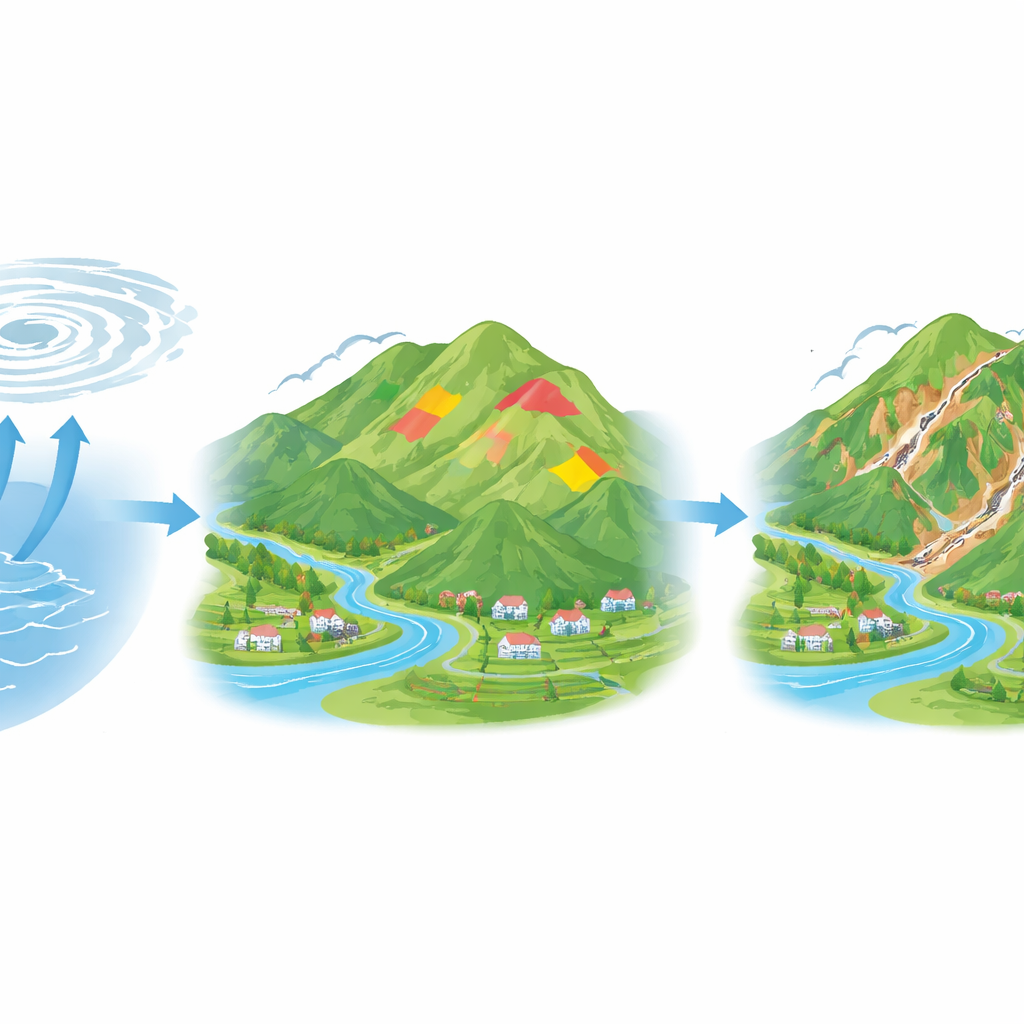
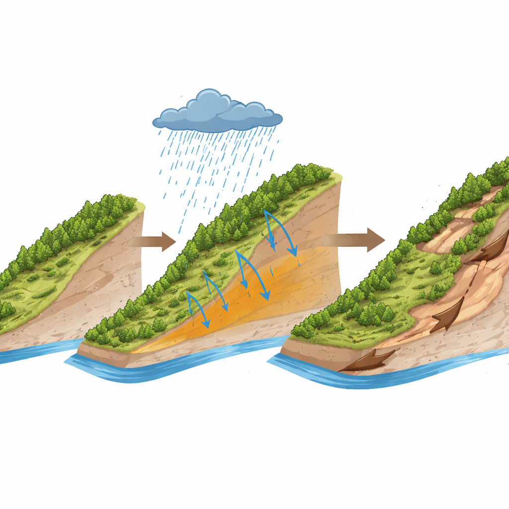
When a powerful typhoon sweeps ashore, most people worry first about wind and flooding. But in steep, rainy regions, another danger quietly unfolds: whole hillsides can suddenly give way. This study looks at one such event in Taishun County, Zhejiang Province, where Typhoon Meranti in September 2016 triggered thousands of landslides. By piecing together satellite images, rainfall records, and advanced computer models, the researchers show how intense rain, rugged terrain, and local geography combine to turn stable green slopes into fast-moving rivers of earth.
Where the Ground Gave Way
The team focused on a mountainous area in southeastern China that often lies in the path of typhoons. Using high‑resolution satellite images taken before and after Meranti, along with field checks on the ground, they mapped 4,102 landslides across an area of about 3,400 square kilometers. Most slides were relatively small, but together they covered more than six square kilometers. The landslides clustered in a belt running northwest to southeast through the central mountains, matching the path of the heaviest rainfall. Many slopes showed long, narrow scars with bare earth and broken vegetation, a typical pattern for rain‑driven failures in this region.
Rain, Hills, Rivers, and Forests Working Together
To understand why some slopes failed while others nearby stayed put, the scientists examined nine key factors: height above sea level, steepness, slope direction, rock type, vegetation, land use, surface wetness, distance to rivers, and total rainfall during the storm. They found that landslides were most common at moderate elevations (about 400–800 meters) on fairly steep hillsides (25–40 degrees). Slopes facing south and southeast, directly exposed to monsoon rains, failed more often. Soft, deeply weathered rock layers, especially Cretaceous sandstones and mudstones, provided weak foundations. Moderate vegetation cover and forested land, often found on steeper, thicker soils, were also linked with more landslides—not because trees cause failures, but because these environments store more water and sit on more fragile slopes. Being close to rivers increased risk as well, since flowing water can erode the base of slopes and make them easier to undermine during storms.
How Smart Models Reveal Hidden Patterns
The researchers then turned to automated machine learning to turn these ingredients into a practical hazard map. They fed all the mapped landslides, plus an equal number of stable locations, into an “ensemble” of different computer models that learn from examples. This system, called AutoGluon, tests and combines many models to find the most reliable mix. The best combined model could distinguish unstable from stable slopes with very high accuracy. When its predictions were plotted on a map, areas rated as high or very high hazard lined up closely with where landslides actually occurred during Typhoon Meranti, especially in the central mountain belt. The team also used a method known as SHAP to open the model’s “black box” and measure how strongly each factor pushed slopes toward failure or safety.
Finding the Tipping Points for Disaster
The interpretive tools showed that three ingredients matter most: how much rain fell, how high the slope sits, and how steep it is. The model’s internal scores jumped once total rainfall reached around 160–180 millimeters over the key four‑day period of the storm, marking a tipping point beyond which slopes rapidly became unstable. Elevation and slope steepness showed similar threshold behavior: mid‑mountain, moderately to very steep slopes were far more prone to failure than low, gentle hills or very high, rocky peaks. Other factors—such as rock type, moisture concentration in valleys, and vegetation—moderately adjusted the risk up or down, often in nonlinear ways. Together, these patterns explain why landslides emerged in dense clusters rather than being scattered evenly across the landscape.
Turning Insight into Early Warnings
By blending detailed mapping, satellite rainfall data, and transparent machine learning, this study offers a clearer picture of how typhoon rains translate into landslide danger on the ground. For non‑specialists and local officials alike, the key message is straightforward: when very heavy rain falls on mid‑elevation, fairly steep, river‑cut forested slopes, the risk of sudden slope failure rises sharply. The framework developed here can be adapted to other storm‑prone mountain regions, helping authorities target monitoring, early warnings, and protective works to the places most likely to slide in the next big typhoon.
Citation: Xie, C., Xu, C., Xu, X. et al. A systematic assessment of regional landslide risk under typhoon rainfall: a case study of Taishun, Zhejiang, China in September 2016. Sci Rep 16, 10857 (2026). https://doi.org/10.1038/s41598-026-46166-w
Keywords: landslides, typhoon rainfall, mountain hazards, machine learning, early warning