Clear Sky Science · en
Delineation of shear zone-hosted mineral targets within the Arabian-Nubian Shield, Egypt, using aeromagnetic data
Why this hidden desert story matters
Deep beneath the rocky hills of Egypt’s southern Eastern Desert lies a complex geological engine that may host valuable deposits of gold, copper, and rare earth elements. Instead of sending large field crews to comb this harsh landscape, the authors of this study used subtle variations in Earth’s magnetic field, measured from aircraft, to draw a first map of the most promising places to look. Their work shows how “seeing” the invisible architecture of the crust can guide smarter, cheaper and less disruptive mineral exploration.
A vast ancient landscape under the sand
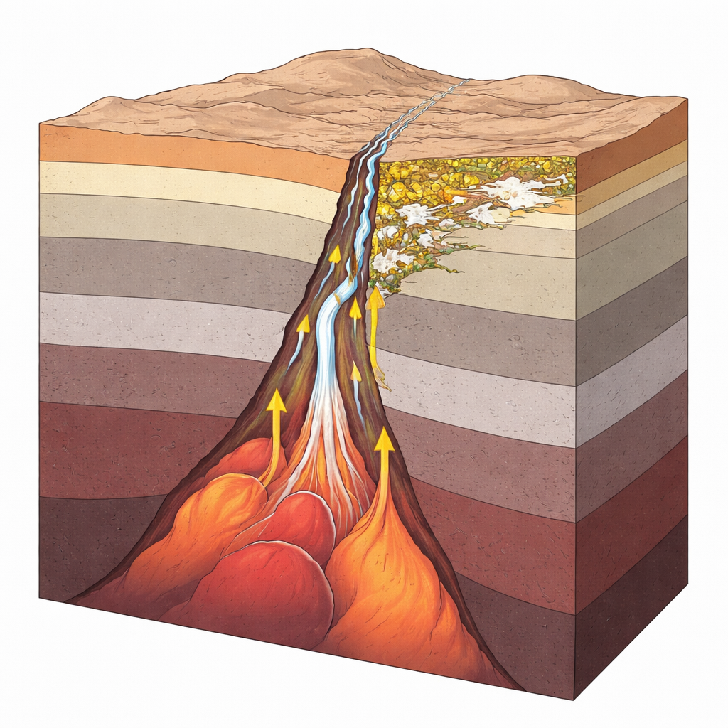
The study focuses on a broad swath of desert between the Nile Valley and the Red Sea, part of the Arabian–Nubian Shield, a belt of ancient rocks that formed more than half a billion years ago. This region records a long history of ocean basins opening and closing, volcanic island arcs colliding, and continents welding together. As a result, the area is built from a patchwork of old ocean crust, volcanic rocks, granites, and high‑grade metamorphic rocks that were once buried deep and later brought back toward the surface. Many of these rock types are already known elsewhere in the shield to host gold veins, copper‑rich volcanic deposits, and granites enriched in rare earth elements used in electronics and clean energy technologies.
Invisible clues from the sky
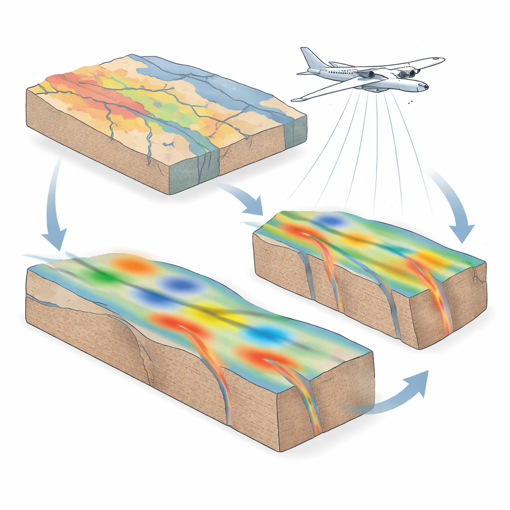
Because much of this geology is covered or heavily deformed, the team turned to airborne magnetic data—measurements of tiny variations in Earth’s magnetic field collected by aircraft decades ago and compiled into a regional grid. Different rocks contain different amounts of magnetic minerals such as magnetite, so they subtly strengthen or weaken the local magnetic field. By carefully reprocessing these regional data with modern techniques, the authors sharpened the signal from both shallow and deep structures. They applied a suite of mathematical filters that enhance edges, highlight contrasts, and emphasize places where the magnetic character changes abruptly, which often correspond to faults, shear zones, and contacts between rock units.
Tracing the desert’s hidden fractures
The processed maps reveal that the subsurface is crisscrossed by long, linear zones of deformation known as shear zones, many trending northwest across the study area. Three in particular—the Kharit–Hodein Megashear Zone, the Nugrus Shear Zone, and the Allaqi–Heiani system—stand out as major crustal corridors. These structures slice through contrasting rock blocks, bound basins that formed later during Cretaceous rifting, and extend to depths of several kilometers. By examining the shape and intensity of magnetic anomalies, and using depth‑estimation techniques, the authors infer clusters of magnetic sources ranging from near the surface down to roughly 18 kilometers, indicating deep‑rooted structures and possible intrusive bodies feeding them.
From patterns to potential ore zones
To move from pure structure to mineral potential, the researchers looked for places where several favorable factors coincide. They mapped the density and orientation of magnetic lineaments, identified circular and ring‑like patterns that may signal buried intrusions, and compared these with known geological maps. Where strong magnetic highs meet complex structural intersections—especially near the Wadi Kharit basin and the margins of the Hafafit Core Complex—the patterns suggest zones where magma and hot fluids could have repeatedly traveled and pooled. Such settings are prime candidates for orogenic gold veins, copper‑rich volcanic systems, and rare‑earth‑bearing granites and pegmatites. The team grouped the region into high‑, moderate‑, and low‑priority zones to steer future fieldwork toward the most promising areas.
What the findings mean for future exploration
The authors emphasize that their study is an informed prediction, not proof of buried ore bodies. Airborne magnetics can reveal where the crust is broken, thickened, or intruded, but only on‑the‑ground mapping, sampling, and drilling can confirm actual mineral deposits. Even so, this work turns a vast and underexplored desert into a focused set of testable targets, dramatically reducing the area that needs intensive study. More broadly, it demonstrates how legacy geophysical data, reanalyzed with modern methods, can help countries like Egypt identify potential mineral resources while limiting environmental disturbance and financial risk. For readers, it is a vivid example of how invisible fields measured far above our heads can illuminate what lies kilometers beneath our feet.
Citation: Shawky, Z.A., Khalil, A.E., Arafa-Hamed, T. et al. Delineation of shear zone-hosted mineral targets within the Arabian-Nubian Shield, Egypt, using aeromagnetic data. Sci Rep 16, 12702 (2026). https://doi.org/10.1038/s41598-026-45708-6
Keywords: airborne magnetics, mineral exploration, Arabian Nubian Shield, shear zones, gold and copper deposits