Clear Sky Science · en
Toward accelerating fluvial morphodynamic simulations through a speed accuracy trade-off assessment
Rivers That Shape Our Lives
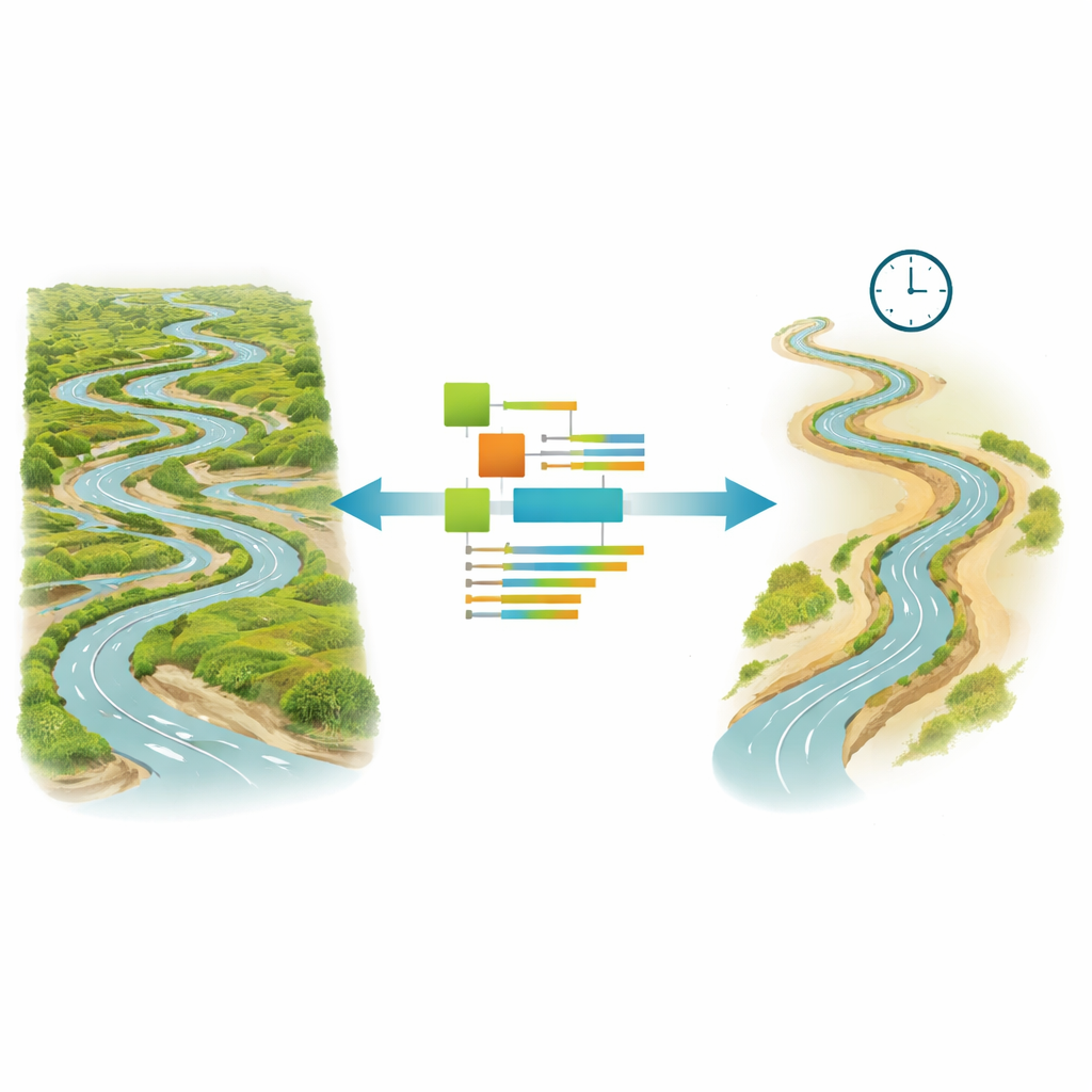
Rivers carve valleys, build floodplains, and quietly rearrange the ground beneath our feet. These slow but powerful changes influence where towns can safely grow, how bridges should be designed, and how climate shifts may reshape landscapes over decades. Yet simulating this long-term river behavior on computers can take so much time that it becomes nearly impractical. This study explores how scientists can dramatically speed up realistic riverbed simulations while keeping the results accurate enough for real-world planning.
Why Simulating River Change Is So Hard
Modern computer models try to mimic how water flows and how grains of sand and gravel move along a riverbed. They account for the energy of flowing water, the resistance of the channel’s banks and bed, and the constantly shifting balance between erosion and deposition. To stay stable and realistic, these models must march forward in tiny time steps, sometimes hour by hour, over years of changing flow. For a sinuous, sand-bed river in Kansas called the Ninnescah River, that means tracking vast numbers of grid cells, each with its own water depth, speed, and sediment behavior. The result is a serious bottleneck: simulating decades of river evolution can demand weeks or months of computing.
Speeding Up Time in the Computer
The first strategy tested in this work is called a morphological acceleration factor, or “morfac.” In essence, morfac lets the model speed up the riverbed’s response without changing the underlying physics. After each small step in the water-flow calculation, the bed changes are multiplied by a chosen factor, allowing the model to jump forward in morphological time. The team compared several factors—ranging from modest boosts to more aggressive jumps—against a full, unaccelerated run for a one-year period that included major floods. They found that moderate acceleration, up to about twenty times, preserved the overall patterns of erosion and deposition along the Ninnescah while shortening the effective flow record by roughly 95 percent. Pushing the factor higher, however, caused the model to misrepresent flood behavior and sediment transport, leading to large errors.
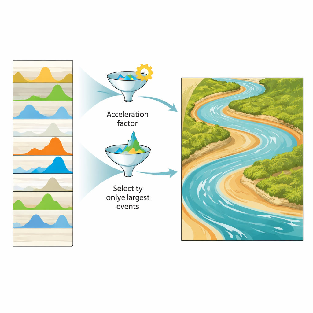
Keeping Only the Most Important Floods
The second strategy focuses on the river’s input: the sequence of flows over many years, known as the hydrograph. Instead of simulating every hour of gently varying discharge, the researchers asked which flood events truly drive meaningful changes in channel shape. They built “condensed” hydrographs from an eight-year record by selectively keeping the largest, most geomorphically active events and trimming away long periods of low flow. Two flavors of this approach were tested. One method kept entire flood events, from initial rise to final fall, whenever their peaks exceeded a chosen threshold. The other kept only the slices of time when flows were above that threshold. By tuning these thresholds, they explored how much of the original record could be discarded while still reproducing realistic riverbed evolution.
Balancing Speed and Trustworthy Results
To judge whether these shortcuts were acceptable, the authors compared each accelerated scenario to a detailed reference run using several statistical measures. They tightened existing standards for what counts as “excellent” performance, recognizing that river models are increasingly used for high-stakes decisions. Their analysis showed that a morfac value of 20 offered a strong trade-off between speed and accuracy. When combined with carefully condensed hydrographs—particularly those that retain flows near the river’s bankfull level—the approach achieved theoretical runtime reductions of more than 98 percent, and in some cases over 99 percent, while still matching the reference patterns of erosion and deposition surprisingly well. Thresholds set far above typical bankfull floods, however, stripped out too much information and caused the models to fail.
What This Means for Rivers and Society
For non-specialists, the key message is that we can now explore long-term river change with far less computational effort, without resorting to oversimplified black-box tools. By smartly speeding up the simulated riverbed response and focusing on the most influential floods, scientists can run multi-year and even multi-decade simulations that were previously out of reach. This opens new possibilities for planning river restoration, assessing climate impacts, and designing infrastructure that must endure in ever-shifting channels. The study also highlights a necessary caution: every gain in speed comes with some loss of detail, so the chosen settings must be matched to the questions at hand. Tested here on one meandering river, this framework provides a roadmap for extending efficient, physics-based river modeling to many different landscapes around the world.
Citation: Fathi, M.M., Smith, V., Fernandes, A.M. et al. Toward accelerating fluvial morphodynamic simulations through a speed accuracy trade-off assessment. Sci Rep 16, 14459 (2026). https://doi.org/10.1038/s41598-026-44428-1
Keywords: river modeling, sediment transport, flood events, computational efficiency, landscape change