Clear Sky Science · en
Remote sensing-based landslide prediction and risk assessment using a hybrid CNN–LSTM deep learning model
Why knowing where hills may fail can save lives
Landslides can strike with little warning, burying homes, blocking roads, and damaging vital infrastructure. In mountainous regions, especially where rain is intense and the ground is already stressed, people live and travel beneath slopes whose stability is hard to judge by eye. This study shows how satellite data and an advanced kind of pattern-recognizing computer model can work together to pinpoint which parts of a large region are most likely to slide, giving planners and emergency managers a powerful new way to reduce risk.
Seeing risky slopes from space
The researchers focus on Kerman Province in southeastern Iran, a landscape of high mountains, deep valleys, and dry plains shaped by active faults and a harsh climate. In such rugged terrain, traditional field surveys are slow and incomplete. Instead, the team turns to remote sensing: satellite images that reveal land cover and vegetation, and digital elevation models that describe the height and steepness of the ground. From these sources they derive key properties such as slope angle, direction, and indicators of how water tends to collect or flow. They also map how close each location is to rivers, roads, and faults, and classify how the land is used, from farms to bare rock.
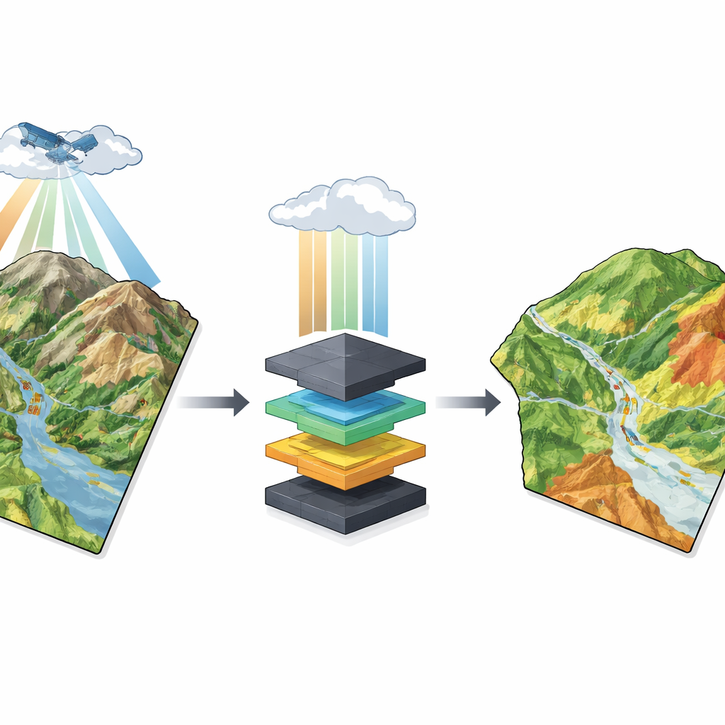
Following the story of water over time
Yet landslides are not driven by land shape alone. Water, arriving as rain or stored in reservoirs, can gradually weaken slopes until they fail. To capture this changing side of the problem, the study compiles daily records of rainfall and reservoir levels. For every spot in the region, the model looks back over the 30 days leading up to a known landslide—or to a period with no failure—to see how much water arrived and how it changed from day to day. This rolling one‑month window allows the method to recognize not just extreme downpours, but also the cumulative effect of many wet days that slowly saturate the ground.
Teaching a hybrid model to read space and time
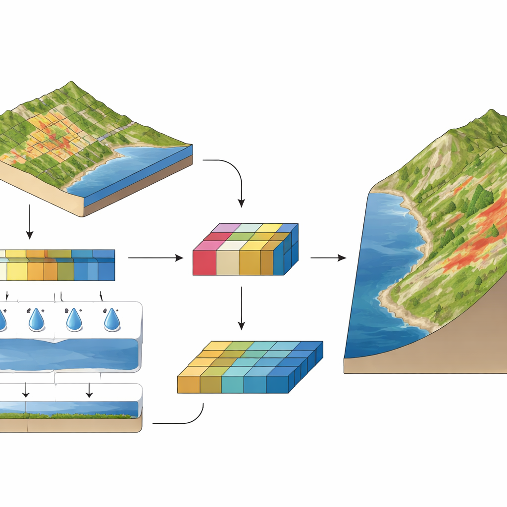
At the heart of the work is a hybrid deep learning model that combines two complementary techniques. One part, called a convolutional neural network, specializes in recognizing patterns across space. It examines small patches of the stacked terrain and land-use layers, learning which combinations of slope, rock type, and other factors tend to be associated with past landslides. The other part, a long short‑term memory network, is designed to handle sequences. It reads the 30‑day chains of rainfall and reservoir levels, learning which temporal patterns are most dangerous. The model fuses these two streams—where the slope is and how wet it has recently been—into a single assessment of how likely each location is to slide.
Testing against real landslides
To judge how well their system works, the authors assemble an inventory of 719 documented landslides from reports, field checks, and detailed images, and match them with an equal number of stable locations. They split this data into training and independent test sets, making sure the model never sees the test examples during learning. When challenged with the unseen cases, the hybrid model correctly distinguishes landslide from non‑landslide sites more than 95 percent of the time and produces one of the highest possible scores on a standard diagnostic curve. It outperforms widely used methods such as support vector machines, decision trees, random forests, and even simpler deep learning models that use only space or only time.
Turning predictions into useful maps
Using the trained model, the team generates a continuous probability of landslide occurrence for every grid cell across Kerman Province, then classifies the results into low, medium, high, and very high susceptibility. About one quarter of the region falls into the high‑risk group, mainly on steep slopes where rainfall and reservoir changes are pronounced, while roughly one third is considered low risk. When the authors overlay their map with the independent landslide inventory, more than 86 percent of recorded events lie within the high and very high zones, showing that the model’s warnings align closely with real‑world failures. An analysis of the inputs confirms that slope steepness is the dominant factor, closely followed by total recent rainfall and shifts in reservoir levels.
What this means for people on the ground
In simple terms, the study demonstrates that combining "where" information from satellites with "when" information about water creates a much sharper picture of landslide danger than either alone. The hybrid model does not forecast the exact day a slope will fail, but it does reveal which areas are inherently fragile under typical wet conditions. That knowledge can guide safer road and building placement, highlight villages and infrastructure that need protection or monitoring, and help emergency planners focus scarce resources where they are most needed. The approach is also flexible: with suitable data, it can be adapted to other mountainous regions facing similar threats from gravity and water.
Citation: Teng, F., Ekraminia, S.S., Zarei, A. et al. Remote sensing-based landslide prediction and risk assessment using a hybrid CNN–LSTM deep learning model. Sci Rep 16, 10687 (2026). https://doi.org/10.1038/s41598-026-43927-5
Keywords: landslide susceptibility, remote sensing, deep learning, risk mapping, hazard prediction