Clear Sky Science · en
Widening of the tropics in global surface-air winds
Why the Edges of the Tropics Matter to You
The tropics are not just sunny vacation zones; they are the engine room of Earth’s weather. Where the tropical air rises and sinks helps determine where rainforests thrive, where deserts spread, and where storm tracks pass. This study asks a deceptively simple question with big consequences: are the tropical climate zones getting wider as the planet warms? By carefully tracking near-surface winds over the world’s oceans, the authors find that the tropics have indeed expanded over the past three decades, especially toward the northern midlatitudes where many people live and farm.
Following the Global Wind Highways
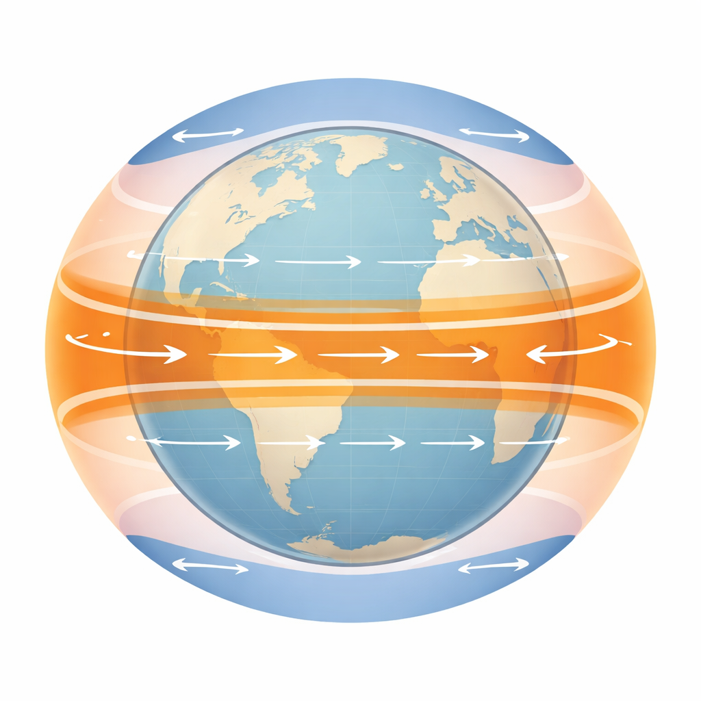
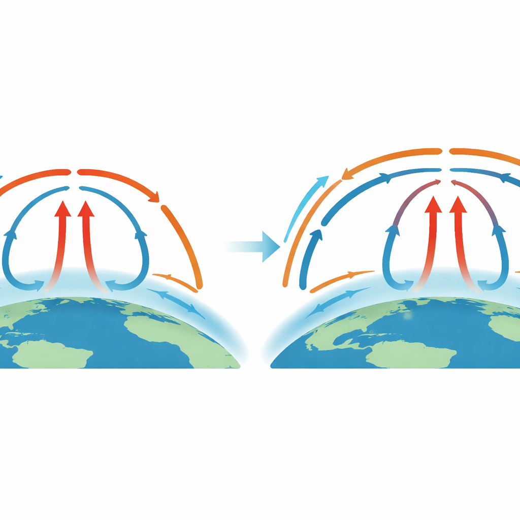
Because you can’t draw a hard line on the map that says “here the tropics end,” scientists rely on indirect clues, or proxies, to track the tropical belt. Traditionally, they have looked at features high in the atmosphere, such as the height of the tropopause, the position of jet streams, or the circulation pattern known as the Hadley cell. These metrics often disagree with one another and can be muddied by other influences, such as changes in ozone or regional heating patterns. The new work focuses instead on a very down‑to‑earth signal: the way near‑surface winds switch from easterly trade winds in the tropics to westerlies in the midlatitudes. The latitude where the average east–west wind at the surface changes sign is tightly linked to the edge of the tropical circulation and occurs within the layer of air that directly affects clouds, storms, and moisture over the oceans.
Using Ocean Winds as a Global Yardstick
To track this wind flip line around the globe, the authors draw on the Cross‑Calibrated Multi‑Platform (CCMP) ocean surface wind product. CCMP blends many satellite instruments that sense tiny ripples on the sea surface with a background weather analysis, producing a dense, nearly continuous record of surface winds over the oceans since the mid‑1990s. Because the data are anchored strongly in direct satellite observations and avoid complex boundary‑layer physics inside weather models, they offer a cleaner view of long‑term trends. The researchers combine CCMP winds with independent estimates of ocean surface currents, ensuring that the winds they analyze truly represent the movement of air relative to Earth’s surface rather than to the moving sea beneath.
Detecting a Growing Tropical Belt
By following where the average surface wind over each hemisphere crosses from westward to eastward, the study reconstructs the effective “width” of the tropics from 1995 to 2024. The analysis shows that the distance between the northern and southern wind‑reversal lines has grown by a little more than two degrees of latitude—on the order of a couple of hundred kilometers—over three decades. Most of this widening occurs in the northern hemisphere, with particularly strong signals over the North Pacific and noticeable changes over the North Atlantic in winter. The authors also check whether known climate oscillations, such as El Niño, the Pacific Decadal Oscillation, and the Atlantic Multidecadal Oscillation, could be masquerading as long‑term trends. Using statistical techniques, they find that these natural ups and downs can explain some year‑to‑year wiggles but do not erase the underlying expansion.
How Well Do Climate Models Keep Up?
The newly detected widening offers a valuable test for modern climate models. The authors compare their observed trends with simulations from dozens of leading atmospheric models run with historically observed sea surface temperatures. In the southern hemisphere, the models generally match the observed poleward shift of the tropical boundary. In the north, however, many models produce little or no widening, even though the observations show a clear expansion. This mismatch suggests that, while models can reproduce broad features like global temperature rise and changes in outgoing radiation, they may be missing key details of how the lower atmosphere circulates and interacts with clouds and oceans in the northern midlatitudes.
What a Wider Tropics Means for People and Places
For a non‑specialist, the bottom line is straightforward: the band of sinking, drying air on the edge of the tropics—home to many of the world’s deserts—is creeping toward higher latitudes, especially in the northern hemisphere. That shift, if it continues, could favor drier conditions and expanding arid zones in regions such as the subtropical parts of North America and other populated areas. Because the signal is detected directly in near‑surface winds over the oceans, it speaks to the very layer of air that governs moisture supply, low clouds, and storm formation. The results strengthen the case that global warming is reorganizing not just temperatures, but the geography of climate zones themselves, and they highlight the need to refine climate models so that they better capture these shifts and their implications for future water resources and habitability.
Citation: Leroy, S.S., Vannah, S. Widening of the tropics in global surface-air winds. Sci Rep 16, 12344 (2026). https://doi.org/10.1038/s41598-026-43234-z
Keywords: tropical widening, surface ocean winds, Hadley circulation, climate change, desert expansion