Clear Sky Science · en
Seismological analysis of the tectonic evolution of the Laji Shan fault from the 2023 Jishishan MS 6.2 earthquake
Why a Deep Earthquake Matters to Everyday Life
The 2023 Jishishan earthquake in western China was moderate in size but puzzling in its effects: the ground at the surface barely shifted, yet shaking was strong enough to damage buildings and trigger many landslides, even some distance from the epicenter. This paper uses advanced computer simulations and field data to uncover how the hidden fault beneath the Laji Shan mountains broke, why the strongest shaking appeared away from the obvious source, and what this tells us about long‑term mountain building and future earthquake hazards in the region. 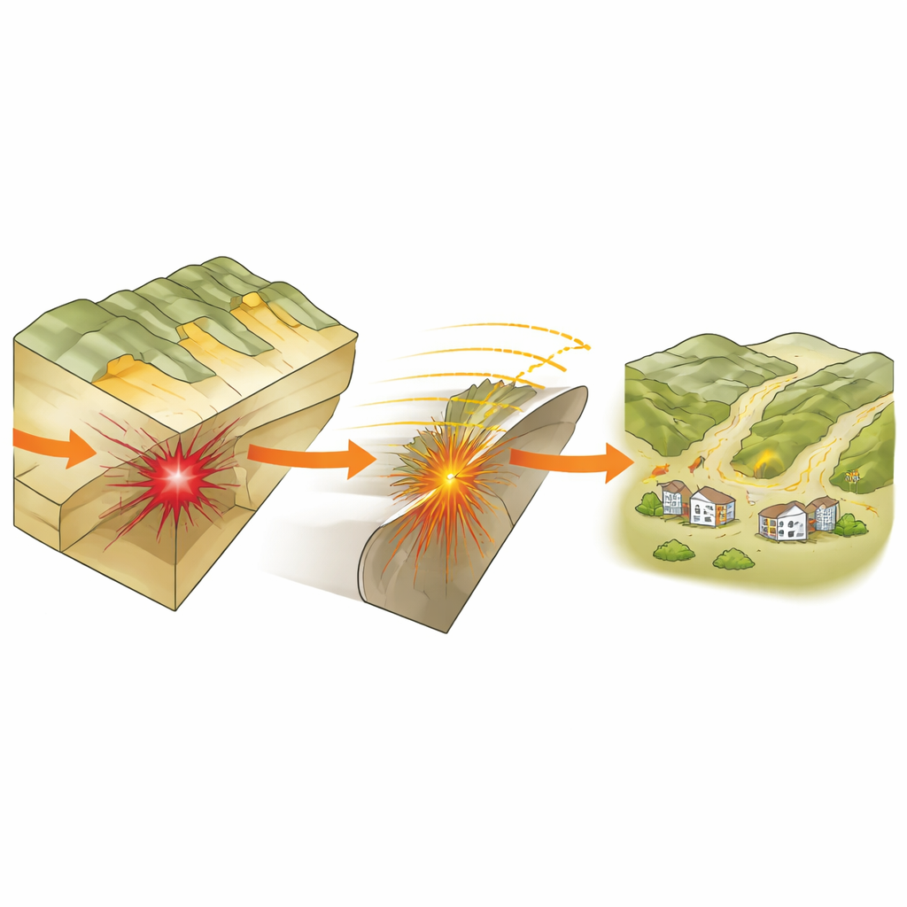
The Mountain Belt and Its Hidden Breaks
The study area lies along the northeastern edge of the Tibetan Plateau, where huge blocks of crust are squeezed together by ongoing collision between continents. Here, long mountain ranges and deep basins alternate in stripes, separated by major faults that slowly reshape the landscape. The Laji Shan fault zone forms a key boundary between neighboring basins and has risen more than two kilometers above the surrounding terrain. Although geological evidence shows that this fault has been active over millions of years, modern measurements suggested it was comparatively quiet, with only modest uplift and mainly smaller quakes. The Jishishan event therefore offered a rare chance to see this fault zone in action and test ideas about how it has evolved through time.
Reconstructing the Hidden Tear
Because the Jishishan earthquake did not tear open the ground surface, the authors had to infer what happened at depth by combining several lines of evidence. They used precise locations of thousands of aftershocks, satellite measurements of tiny surface warps, strong‑motion recordings from nearby instruments, and earlier models of how the fault slipped. With this information they built a three‑dimensional computer model of a northeast‑dipping fault plane beneath the southern margin of the Laji Shan. They then ran dynamic simulations that mimic how stress builds, how friction weakens, and how a rupture front races along a fault. The resulting pattern of slip and timing closely matched independent estimates of the quake’s size and duration, giving confidence that the model captures the real event. 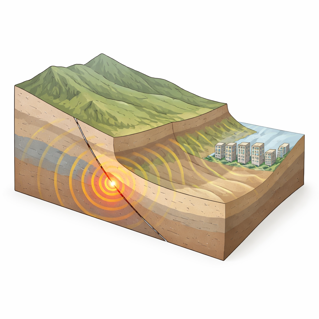
A Rupture That Dives Instead of Breaking the Surface
The simulations reveal that the fault patch that broke was about 15 kilometers long and that the main slip concentrated roughly 10 kilometers deep. The rupture started near the hypocenter and spread mainly northwestward and downward along the fault, rather than upward toward the surface. Peak slip speeds were moderate and the total rupture lasted about eight seconds. Because the break stayed buried, the ground at the surface above the fault moved only a few centimeters, explaining the weak permanent deformation mapped by satellite. Yet the deep, downdip rupture pumped out strong, long‑period seismic waves that travel efficiently through the crust. These waves tend to shake taller buildings more and can grow stronger in softer, basin‑filling sediments, shifting the pattern of damage away from the fault trace.
Why Damage Was High Where Deformation Was Low
Field surveys after the quake found that towns and slopes some 15 to 20 kilometers northeast of the epicenter suffered more damage than places closer in. The simulations help explain this “weak deformation–high intensity” puzzle. First, the event was a thrust quake, which naturally focuses shaking into the block of rock above the slipping fault, known as the hanging wall. Second, the rupture’s downward path concentrated energy at depth, enriching long‑period motions that traveled outward. Third, several nearby basins with thick sediment layers acted like bowls that trap and amplify seismic waves, especially near their edges. Together, the hanging‑wall effect, basin edge effects, and internal focusing of waves boosted shaking and landslide occurrence in the far‑field basins even though surface offsets were small.
Clues to the Long Life of a Fault Zone
Beyond reproducing this single event, the study links the rupture behavior to the long structural history of the Laji Shan region. The Laji Shan fault zone has been active since at least the early Paleozoic era and now forms an arc-shaped belt with differently dipping fault strands and uplifted rock blocks. The simulations suggest that strong, older structures in the upper crust acted as barriers that blocked the rupture from breaking upward, while deep segments with favorable rock properties allowed slip to continue downdip. The pattern of aftershocks, mostly above and around the main deep slip patch, supports this view. In simple terms, the way this earthquake unfolded was not random: it was guided by the ancient architecture of the mountains.
What This Means for Future Risk
For non‑specialists, the main message is that the most dangerous shaking in an earthquake does not always sit directly above the fault that breaks, nor does it require dramatic cracks at the surface. In Jishishan, a buried rupture on the southern side of the Laji Shan, steered by long‑lived geological structures and interacting with nearby basins, produced unexpectedly strong shaking and landslides in distant communities. Recognizing how deep fault geometry, basin shape, and wave focusing work together can improve seismic hazard maps, guide safer building design in basin towns, and refine our understanding of how the Tibetan Plateau continues to rise and deform over time.
Citation: Xie, Z. Seismological analysis of the tectonic evolution of the Laji Shan fault from the 2023 Jishishan MS 6.2 earthquake. Sci Rep 16, 13434 (2026). https://doi.org/10.1038/s41598-026-42900-6
Keywords: earthquake rupture, Laji Shan fault, seismic hazard, Tibetan Plateau, ground motion amplification