Clear Sky Science · en
Understanding tens of thousands of pockmarks and domes using machine learning (Gulf of Lions, NW Mediterranean Sea)
Hidden Bumps and Hollows Beneath the Waves
Far below the surface of the northwestern Mediterranean, the seafloor is anything but smooth. It is dimpled with tens of thousands of small hills and pits that quietly record how buried fluids and gases move through the Earth. This study explores those features in the Gulf of Lions, off southern France, using seafloor mapping, seismic imaging, and machine learning to understand what shapes the seabed, where, and why. The work matters not only for basic geology, but also for how methane and groundwater escape into the ocean and how stable the seafloor really is in a heavily used coastal area.
Strange Shapes on the Seafloor
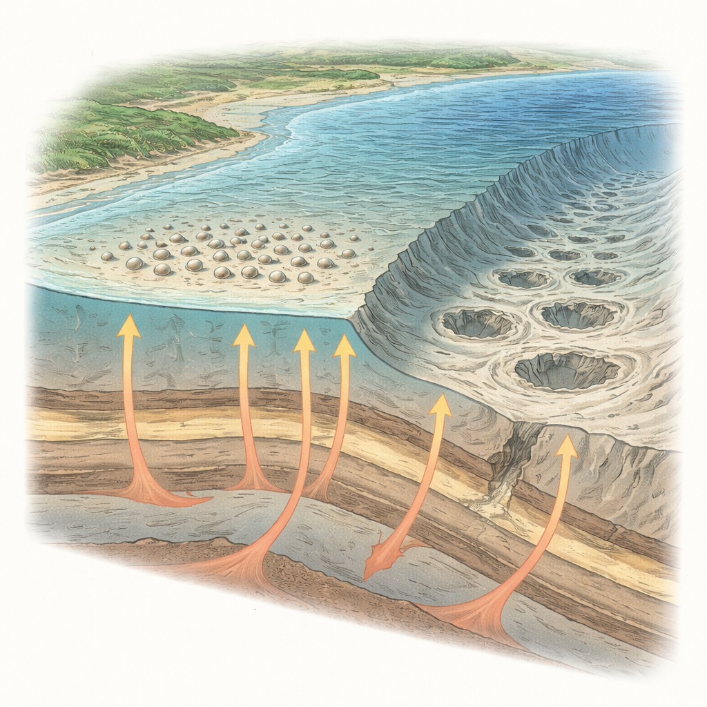
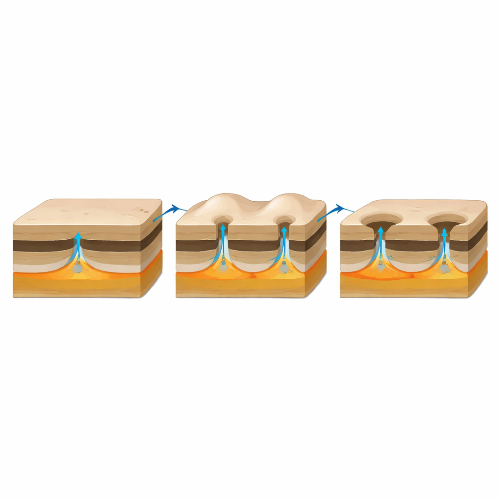
The authors focus on two main kinds of seafloor features. "Domes" are low, rounded mounds that rise about a meter above the surrounding bottom and are typically around 100 meters across. "Pockmarks" are shallow depressions that can range from a few meters to hundreds of meters in size. Both are forms of seabed deformation linked to fluids—mostly gas such as methane and sometimes groundwater—moving upward through sediments. When pressure builds in buried layers, it can push the seabed into a bulge or, after failure, leave a small crater-like hollow. Similar structures have been reported on continental shelves and slopes around the world, but the Gulf of Lions had never been mapped in detail.
Mapping Thousands of Bumps and Pits
To inventory these structures, the team assembled nearly three decades of high-resolution multibeam bathymetry—essentially 3D scans of the seafloor—alongside dense grids of seismic reflection profiles that reveal internal sediment layers. They processed the depth data to highlight only small-scale relief, then automatically measured the height, width, and shape of each anomaly. This effort uncovered 28,572 individual seabed features between 10 and 1,000 meters water depth. Remarkably, about 86% of them are domes; the rest are pockmarks that fall into several distinct size and shape classes and occur in different depth zones and sediment types across the shelf and upper slope.
Letting a Machine Fill in the Gaps
Because detailed seafloor maps do not exist everywhere, the authors used a machine learning model to predict where similar features should occur in unmapped areas. They divided the region into a grid of hexagonal cells and, for each one, calculated environmental variables such as water depth, seafloor slope, the thickness of the youngest sediment package, and the mix of sand, silt, and clay in surface sediments. A LightGBM model learned how these factors relate to the number of domes and different pockmark types where data are available, and then extrapolated to the full gulf. The model suggests that there may be on the order of 55,000 to 80,000 domes and pockmarks in total, revealing that these features are far from rare quirks—they are a fundamental part of the local seabed.
How Sediment, Depth, and Gas Work Together
The statistical analysis shows that different controls dominate for each feature type. Domes cluster where a thick, clay-rich mud belt laid down by the Rhône River thins out seaward, above a key buried surface formed about 7,500 years ago during maximum sea-level rise. Seismic data beneath domes show bright reflections and other telltale signs of trapped gas at this level, consistent with methane accumulating in a permeable layer and pushing up the muddy cap. Medium-sized pockmarks, often the most common kind, tend to appear in the same areas and share similar diameters, suggesting that domes can slowly evolve into pockmarks once overpressure causes collapse. Larger, deep-rooted pockmarks along canyon interfluves on the slope are more strongly controlled by water depth and long-term cycles of sea-level change, which govern how sediments load and squeeze buried gas-rich layers.
Different Stories for Different Pockmarks
Not all depressions are driven by gas. Small, shallow pockmarks nearer shore occur on a reworked wedge of storm-dominated sands and muds and lack seismic hints of gas, pointing instead to groundwater seeping out of coastal aquifers. Another group of broad, flat-bottomed pockmarks sits at roughly the same depth along the shelf and seems to be shaped mainly by waves and currents eroding a coarse shell-rich layer that is tougher than the surrounding mud. Rare "spiky" pockmarks feature a central bump surrounded by a moat-like depression; these lie above buried sand bodies and may form where minerals cement a rigid core that resists erosion while nearby loose sands are scoured away.
What These Seafloor Marks Tell Us
Taken together, the results show that the thousands of bumps and hollows decorating the Gulf of Lions seafloor are not random scars. They are organized by how thick the mud is, how deep the water is, how steep the bottom is, and how coarse or fine the sediments are. Domes likely mark pockets of gas trapped beneath a muddy seal, and many pockmarks record where that seal has broken, allowing fluids to escape. Other pockmarks track groundwater discharge or seafloor erosion. For non-specialists, the key message is that the seafloor is a dynamic, responsive surface: by reading its small-scale relief with modern sensors and smart algorithms, scientists can reconstruct invisible flows of gas and water that matter for climate, ecosystems, and even the safety of seafloor infrastructure.
Citation: Lion, A., Bassetti, MA., Berné, S. et al. Understanding tens of thousands of pockmarks and domes using machine learning (Gulf of Lions, NW Mediterranean Sea). Sci Rep 16, 12234 (2026). https://doi.org/10.1038/s41598-026-42740-4
Keywords: seafloor pockmarks, methane seepage, Mediterranean shelf, subsurface fluids, machine learning geology