Clear Sky Science · en
Structural and lithological controls on landfill site suitability in Tenth of Ramadan City, Egypt using remote sensing and machine learning
Finding Safe Places for City Trash
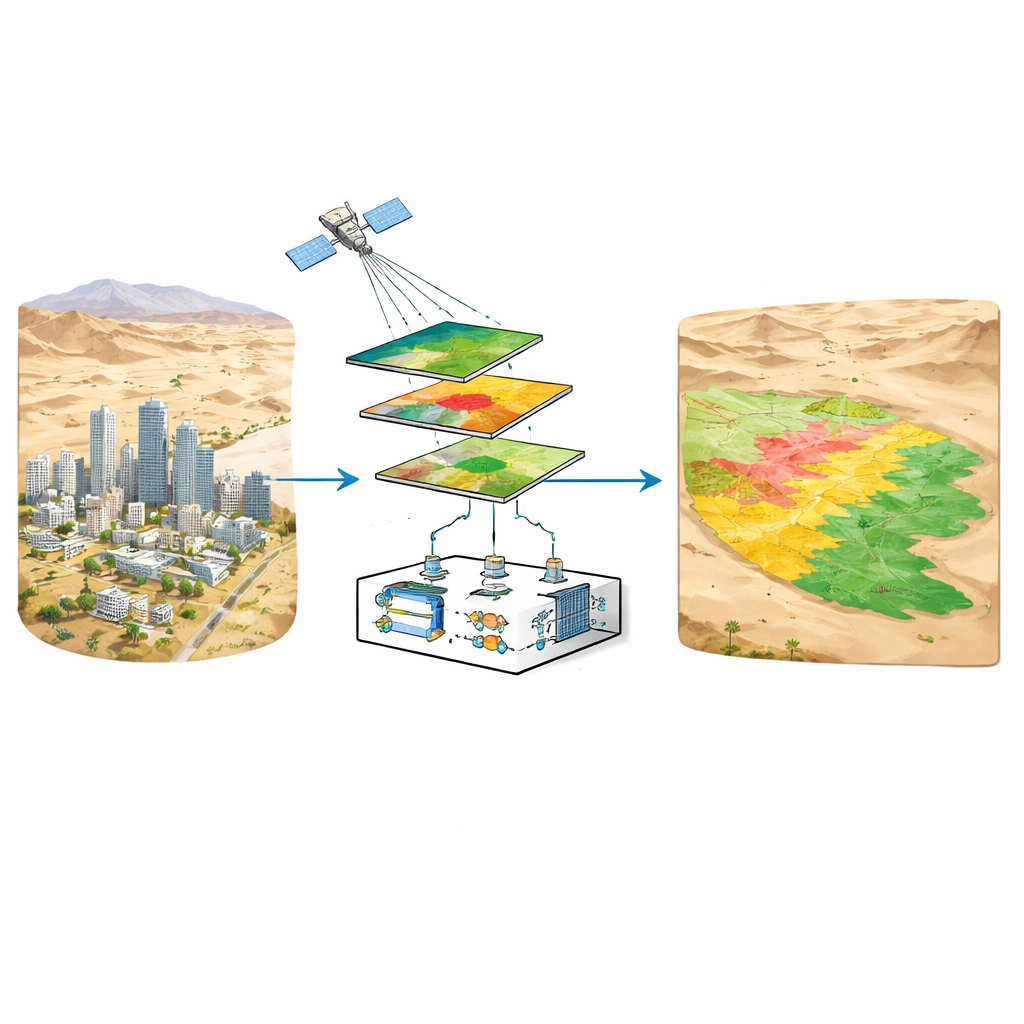
As cities in dry regions grow, one of the hardest planning questions is deceptively simple: where can we safely put the trash? In Egypt’s fast-expanding Tenth of Ramadan City, a landfill built in the wrong spot could let polluted fluids seep into the ground and eventually reach precious groundwater. This study shows how satellite images and modern computer techniques can help planners pick landfill locations that protect both people and water supplies in a harsh desert setting.
A Growing Desert City and Its Hidden Ground
Tenth of Ramadan City sits on the edge of the Nile Delta, surrounded by rocky desert cut by dry valleys. Beneath the bare surface lies a patchwork of rock layers and cracks that strongly influence how water and contaminants move underground. Some layers, such as clays and marls, act like natural barriers that slow seepage. Others, like loose sands and gravels, allow water and pollutants to flow more easily. At the same time, fractures and faults can behave like underground highways, guiding fluids over long distances. Understanding this hidden structure is essential before choosing where to bury household and industrial waste.
Seeing the Ground from Space
Fieldwork alone cannot easily map every rock type and fracture over tens of square kilometers, especially in remote desert terrain. The researchers therefore turned to satellite data and digital elevation models. They used images from the Landsat 5 satellite to distinguish different surface materials based on how they reflect sunlight in several colors, including visible and infrared. They also used a detailed elevation model derived from ASTER data to reveal subtle changes in height and slope that often trace buried faults and changes between rock units. By combining these datasets, they could produce a much sharper geological picture than the older regional maps offered.
Teaching Computers to Read the Landscape
To turn the satellite signals into a reliable rock map, the team employed two types of machine learning. An unsupervised method called K-means automatically grouped pixels with similar color patterns into broad terrain types, giving an early sketch of the area’s main units. Then a supervised method called Support Vector Machine (SVM) was trained with known examples of each rock formation and land cover, including urban areas and roads. After careful correction for the effects of the atmosphere, the SVM produced a lithology map that agreed well with available ground information, correctly classifying more than four out of five test pixels. This finer view also captured recent city growth that older maps missed, which is crucial for avoiding conflicts between new landfills and expanding neighborhoods.
Tracing Cracks and Weak Zones
The scientists then focused on the region’s structural “skeleton” — the fractures and faults that can weaken the ground or channel polluted fluids. They enhanced the satellite images using a mathematical approach called principal component analysis and directional filters that highlight features trending in certain directions. Automated tools extracted linear features, which were then checked by hand against shaded relief and existing maps. The result was a 25% increase in total mapped fracture length compared with legacy data, and clear confirmation that two main fracture directions dominate the area. Maps of fracture density showed where the ground is heavily cut by these structures and therefore more vulnerable to leakage or instability.
Weighing the Best and Worst Spots
Armed with both a detailed rock map and fracture-density map, the team built a decision model to score every part of the study area for landfill suitability. They gave the greatest weight to rock type: areas underlain by tight shale and marl were favored because they naturally slow downward seepage, while loose sands, gravels, and wadi deposits were penalized for their high permeability. Distance from major fractures also mattered: zones far from mapped lineaments were treated as safer than those close to them, which might act as hidden conduits. Urban and infrastructure areas were strictly excluded, and recent city expansion was incorporated using up-to-date boundaries, ensuring that future neighborhoods would not creep toward the landfill.
How Much Land Is Truly Safe?
When all of these factors were combined in a multi-criteria model, only about 16% of the study area emerged as highly suitable for a landfill. These preferred zones share several favorable traits: they lie on low-permeability rock, are structurally quiet with few fractures, sit well away from the city and major roads, and overlie groundwater that is roughly 80 meters deep. The researchers also tested how sensitive their results were to changes in the importance assigned to each factor. Even when they slightly shifted the weights, the most suitable areas remained in the same general locations, suggesting the method is robust enough for real-world planning.
What This Means for Desert Cities
For non-specialists, the takeaway is that choosing a safe landfill site is far more than picking an empty desert patch on a map. This study shows that by combining satellite images, basic elevation data, and smart computer models, planners can quickly narrow down large regions to a small set of geologically secure candidates. In Tenth of Ramadan City, this approach points to a limited number of spots where nature itself — tight rocks, few fractures, and deep groundwater — works together with careful planning to minimize the risk that buried waste will one day poison scarce water resources. The same framework can be adapted to other growing desert-fringe cities that face the twin pressures of rapid expansion and environmental protection.
Citation: Essam, S., Mabrouk, W.M., Soliman, K.S. et al. Structural and lithological controls on landfill site suitability in Tenth of Ramadan City, Egypt using remote sensing and machine learning. Sci Rep 16, 9831 (2026). https://doi.org/10.1038/s41598-026-41772-0
Keywords: landfill siting, remote sensing, machine learning, groundwater protection, urban planning