Clear Sky Science · en
Fusion of residual networks and hybrid attention mechanism for high accuracy cultivated land mapping in northeast china’s black soil region using planet imagery
Why sharper farm maps matter
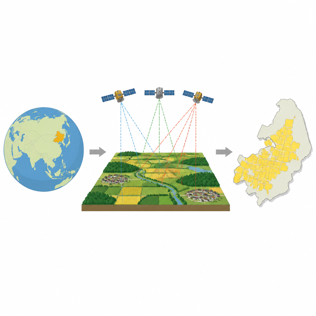
Feeding a large population depends on knowing exactly where our food is grown and how those lands are changing. In Northeast China, some of the world’s most fertile black soils support vast fields of corn, soybeans, and rice. Yet the same forces that make this landscape productive—erosion, freeze–thaw cycles, and varied farming practices—also make it surprisingly hard to map from space. This study shows how a new image–analysis approach can turn everyday satellite pictures into precise maps of cultivated land, helping to safeguard food security and guide smarter land management.
A challenging landscape to see from space
The black soil region of Northeast China is both rich and fragile. While the terrain is mostly flat, long gentle slopes, intense rain, wind, and repeated freezing and thawing wear away the soil. Different crops, irrigation styles, and soil types create a patchwork of colors and textures when viewed from orbit. In satellite images, plowed fields, pasture, bare soil, and even some built–up areas can look confusingly similar. Traditional mapping methods based on simple pixel colors or shallow machine learning often struggle here, leading to noisy maps, fuzzy field edges, and errors that limit their use for planning and policy.
From raw imagery to training data
To tackle this problem, the researchers focused on Youyi County in Heilongjiang Province. They used PlanetScope satellite images with a ground resolution of about three meters, fine enough to show individual field shapes and boundaries. Before any analysis, the images were carefully corrected for atmospheric effects and geometric distortions. Experts then traced thousands of field parcels on screen, converting these outlines into labeled samples that distinguish cultivated land from other surfaces such as water, roads, forests, and buildings. The images were split into many small tiles, and advanced loss functions were used so that difficult, easily confused locations received extra attention during training.
A smarter way to spot fields
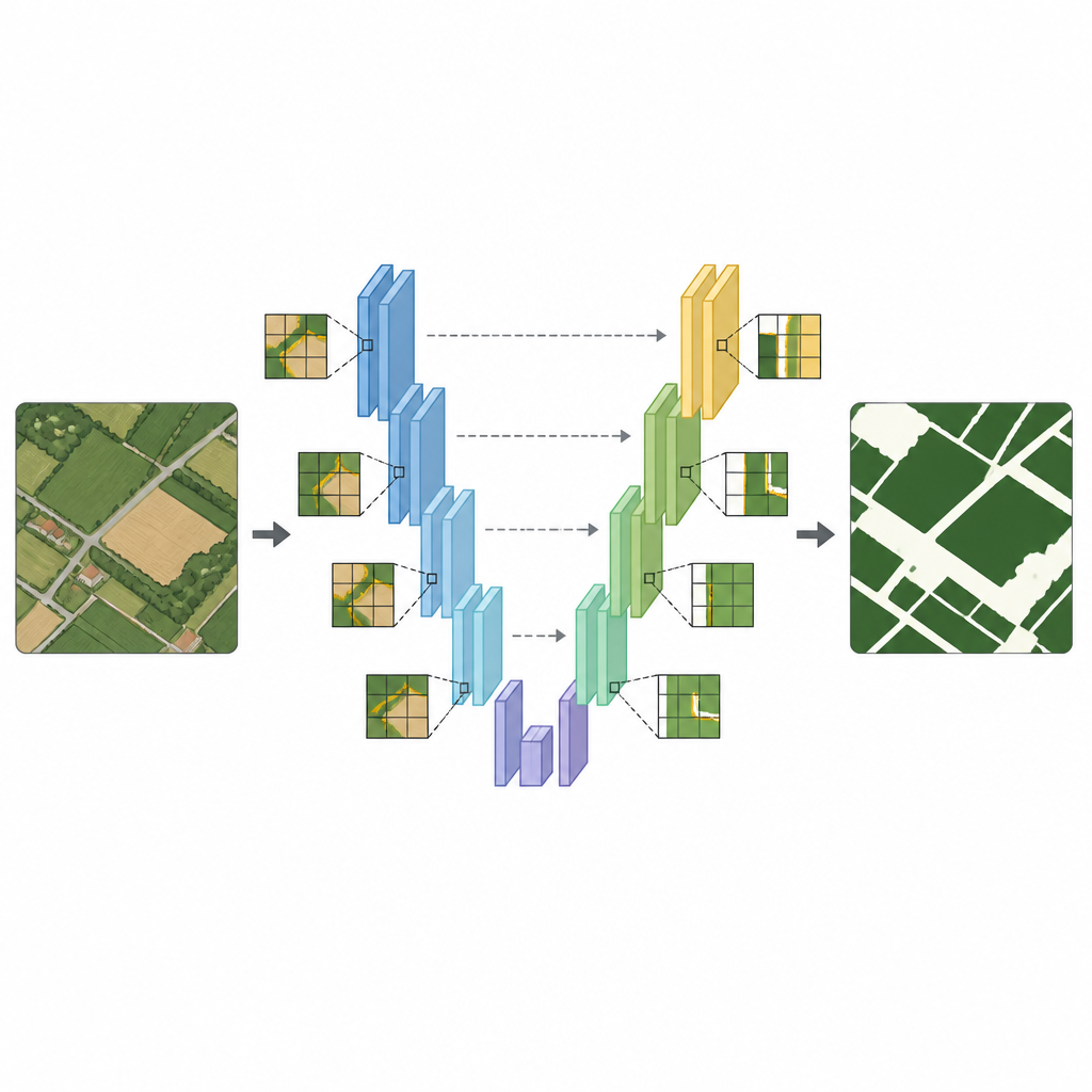
At the heart of the study is an updated image–segmentation network called RC–UNet. It builds on a popular U–shaped deep learning design that learns both broad patterns and fine details. The team replaced the original backbone with a residual network, which helps very deep models keep learning without losing important signals as information flows through many layers. On top of that, they added a hybrid attention module that teaches the network to focus on the most informative parts of the image—both across color channels and across space. In simple terms, the model learns where to look and what matters most when deciding whether a pixel belongs to a crop field.
How well the new approach works
When tested on Youyi County, the RC–UNet network produced highly accurate cultivated land maps, with an overall accuracy of about 96.9 percent and strong agreement between predicted and true field areas. Field boundaries were smooth and closely matched expert interpretations, even near villages and along irregular plot edges. Compared with well–known deep learning models and standard methods such as support vector machines and random forests, RC–UNet consistently scored higher and produced less fragmented, more realistic field patterns. Tests in a second area, Heshan Farm, showed that performance dropped only slightly, suggesting the method can generalize to other parts of the black soil region.
What this means for farms and food
The study shows that combining high–resolution commercial satellite data with a carefully designed deep learning model can map cultivated land with less than 3 percent area error in key test regions. For non–specialists, this means decision–makers can trust these maps to track how much land is under crops, monitor erosion–prone slopes, and spot signs of land loss or misuse. While future work will extend the method to multiple seasons and more crop types, the current results already offer a practical tool for managing valuable black soils and supporting sustainable, intensive agriculture without losing sight of the ground truth.
Citation: Han, Y., Lou, Y., Qin, C. et al. Fusion of residual networks and hybrid attention mechanism for high accuracy cultivated land mapping in northeast china’s black soil region using planet imagery. Sci Rep 16, 14812 (2026). https://doi.org/10.1038/s41598-026-40496-5
Keywords: cropland mapping, remote sensing, deep learning, black soil, PlanetScope