Clear Sky Science · en
A hybrid empirical and semi analytical inversion approach for remote sensing estimation of SPM in Ebinur Lake China
Why these dusty desert lakes matter
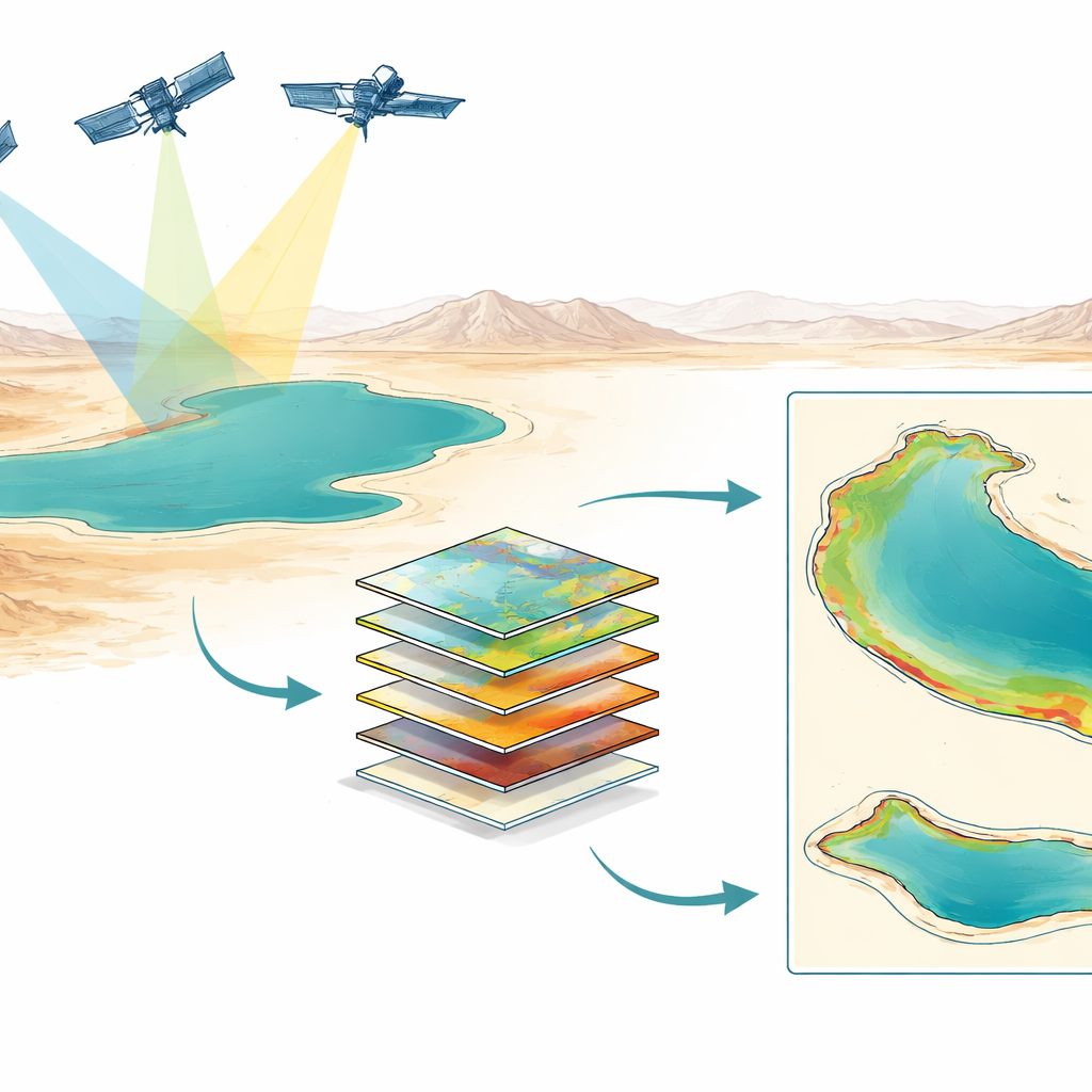
Ebinur Lake in China’s far northwest is a shallow, salty lake ringed by desert. Its waters are thick with suspended particles of silt and salt. Those particles shape the habitat of brine shrimp harvested as valuable “soft gold,” clog irrigation systems, and, when the lakebed dries, become airborne dust that affects nearby towns. But tracking how these particles change over years is hard in such a remote, data-scarce region. This study shows how to combine different satellite sensors and modeling approaches to reliably monitor suspended particulate matter (SPM) over more than a decade in Ebinur Lake and a similar nearby lake.
Clouds of particles above a shrinking lake
Ebinur Lake is a textbook example of how climate and human pressures reshape desert lakes. Rainfall is low, evaporation is intense, and strong winds whip the shallow water roughly two months a year. These winds stir bottom sediments into the water, boosting SPM, and later blow dried lakebed material into vast salt-dust storms. At the same time, the lake’s area has been shrinking, exposing more bare sediment. This threatens both the lake’s fragile wetland ecosystems and the local economy tied to brine shrimp, which need suitable water clarity to thrive. Managers therefore need long-term SPM maps that show how murkiness changes across the lake and through time, something only satellites can provide consistently.
Reading lake color from space
Satellites such as Landsat and Sentinel-2 regularly image Ebinur Lake in visible and near‑infrared light. The study first measured how Ebinur’s unusually salty, turbid water absorbs light across wavelengths, separating the contributions from suspended particles and dissolved organic substances. The authors found that around 695 nanometers, in the deep red region, the lake’s absorption is nearly the same as pure water, and that SPM creates a strong signature in nearby red bands. This insight helps anchor “semi-analytical” models that connect what satellites see (reflected light) to physical properties like how strongly particles absorb and scatter light, which in turn relate to SPM concentration.
Blending physical insight and data-driven models
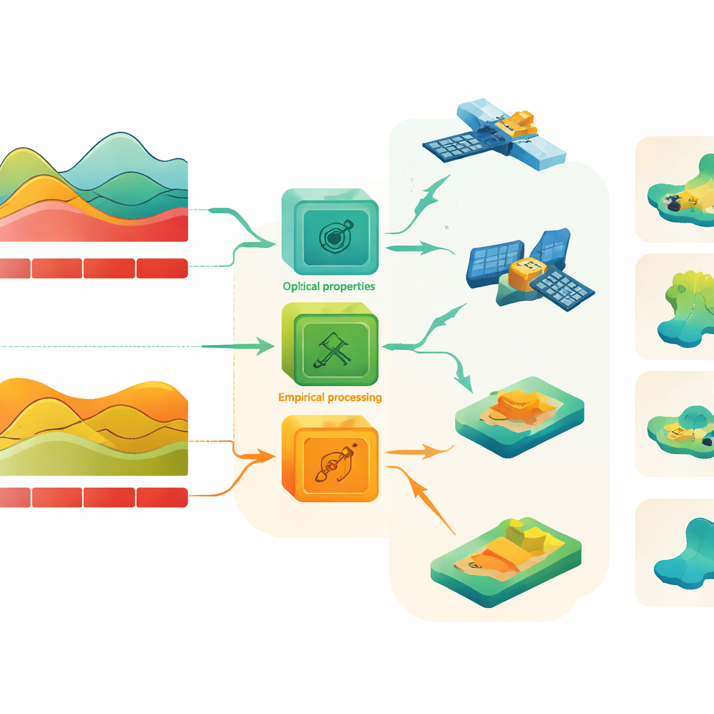
The team compared two model families. Semi-analytical models, such as the Quasi‑Analytical Algorithm (QAA), use knowledge of water optics to derive SPM from satellite reflectance. Empirical models—including simple exponential regressions and several machine‑learning approaches—learn a direct relationship between reflectance and measured SPM at field stations. Using 227 water samples collected between 2011 and 2021, they calibrated and tested these models on Landsat 8 and Sentinel‑2 images of Ebinur Lake, and then checked how well the models transferred to Bosten Lake, a clearer, lower‑SPM lake in the same region. They also used a fusion method called ESTARFM to combine Landsat and MODIS data, filling gaps in the time series while keeping red-band reflectance consistent.
Choosing the right tool for each sensor
The results show that no single model works best in all situations. For Ebinur Lake’s typically high SPM levels, semi‑analytical models clearly outperformed most empirical and machine‑learning models, giving stable maps that matched the spatial patterns visible in satellite images and reaching good agreement with in‑lake measurements. The QAA variant tuned to the red band (around 655–665 nanometers) worked especially well for Landsat 8 and Sentinel‑2, while a carefully chosen exponential regression (EXPM) was more suitable for older Landsat 5/7 sensors and for the fused images. Empirical models trained on Ebinur data largely failed when applied to clearer Bosten Lake, often producing unrealistic, blocky patterns where many neighboring pixels had identical values—evidence that models trained only on very turbid water do not generalize to low‑SPM conditions.
From local case study to broader guidance
By dissecting how Ebinur Lake’s water interacts with light, harmonizing measurements from different satellites, and systematically testing physical and data‑driven models, the authors propose a practical recipe for long‑term SPM monitoring in harsh, data‑poor environments. Use a physics‑guided QAA approach with modern satellites where possible; fall back on well‑behaved empirical models for older or fused datasets; and avoid directly transplanting machine‑learning models from very turbid to clear waters. For local communities and environmental managers, this means more reliable maps of when and where lakes become clouded with particles, supporting better protection of aquatic habitats, more efficient water use, and earlier warning of dust‑storm risks in arid regions around the world.
Citation: Liu, C., Xu, X., Wu, Y. et al. A hybrid empirical and semi analytical inversion approach for remote sensing estimation of SPM in Ebinur Lake China. Sci Rep 16, 10273 (2026). https://doi.org/10.1038/s41598-026-40250-x
Keywords: suspended particulate matter, remote sensing, arid lakes, Landsat Sentinel, water quality monitoring