Clear Sky Science · en
Modeling evapotranspiration in diverse climatic zones of Pakistan using Surface Energy Balance Algorithm for Land (SEBAL) through geospatial technologies
Why the hidden water cycle matters
When we think about climate change and water in Pakistan, we often picture melting glaciers or shrinking rivers. But a quieter process, called evapotranspiration—the combined loss of water from soil, open water, and plant leaves—acts like the landscape’s built‑in air conditioner. This study asks a simple but urgent question: as Pakistan’s cities grow and its climate warms, how is this natural cooling system changing across the country’s very different climate zones?
A country of many climates
Pakistan stretches from icy northern mountains to scorching southern deserts and humid coastal plains. To make sense of this complexity, the researchers divided the country into five broad climate zones, covering high peaks, irrigated river plains, dry western plateaus, hot central lowlands, and the southern coastal belt. Each of these regions has its own mix of farms, forests, cities, and bare land, which means they absorb and release heat and moisture in very different ways. Understanding how much water returns to the air from each zone is crucial for managing crops, cooling cities, and planning for droughts and heatwaves.
Watching the land from space
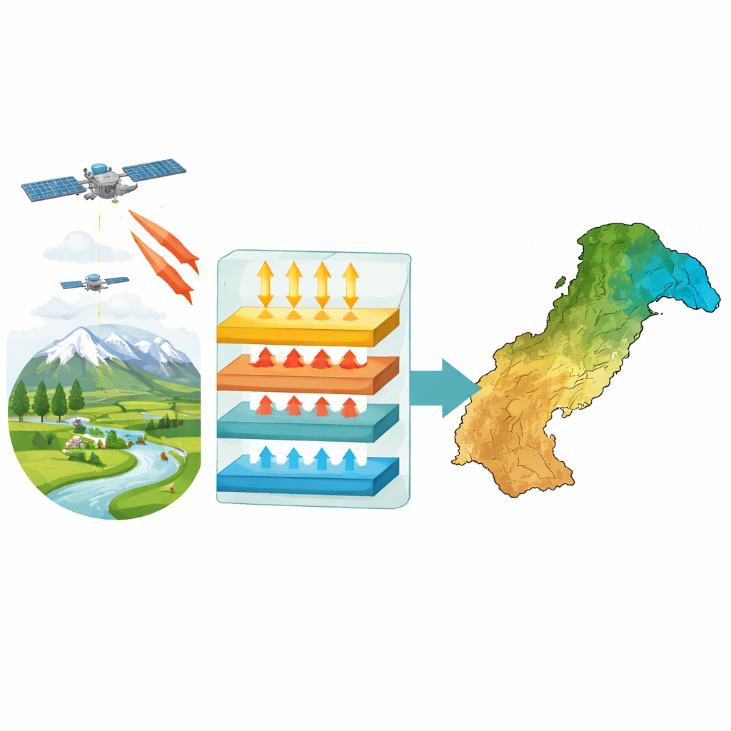
Instead of relying only on weather stations, which are sparse and unevenly distributed, the team turned to satellites. Using three generations of Landsat images from 1989, 1999, 2009, and 2019, they combined detailed pictures of the land’s brightness, greenness, and temperature with records of air temperature, humidity, sunshine, and wind from the Pakistan Meteorological Department. These inputs were fed into a method known as the Surface Energy Balance Algorithm for Land (SEBAL), which essentially tracks how incoming solar energy is split between heating the air, warming the ground, and evaporating water. From this balance, the researchers could estimate how much water was leaving the surface each day across Pakistan, pixel by pixel.
Signs of a warming and drying landscape
The satellite record reveals a clear pattern over three decades. Land surface temperatures rose steadily, especially in the central and southern plains and around major cities, while the cooler northern mountains remained a relative refuge. Vegetation, tracked using a greenness index, generally improved up to 2009 but then declined by 2019 in many areas, particularly where cities expanded and land was degraded. At the same time, the land’s reflectivity decreased, signaling a shift from brighter, bare or lightly covered surfaces toward darker, heat‑absorbing urban and disturbed areas. Net radiation—the total energy available at the surface—increased over much of the country, reinforcing these warming trends.
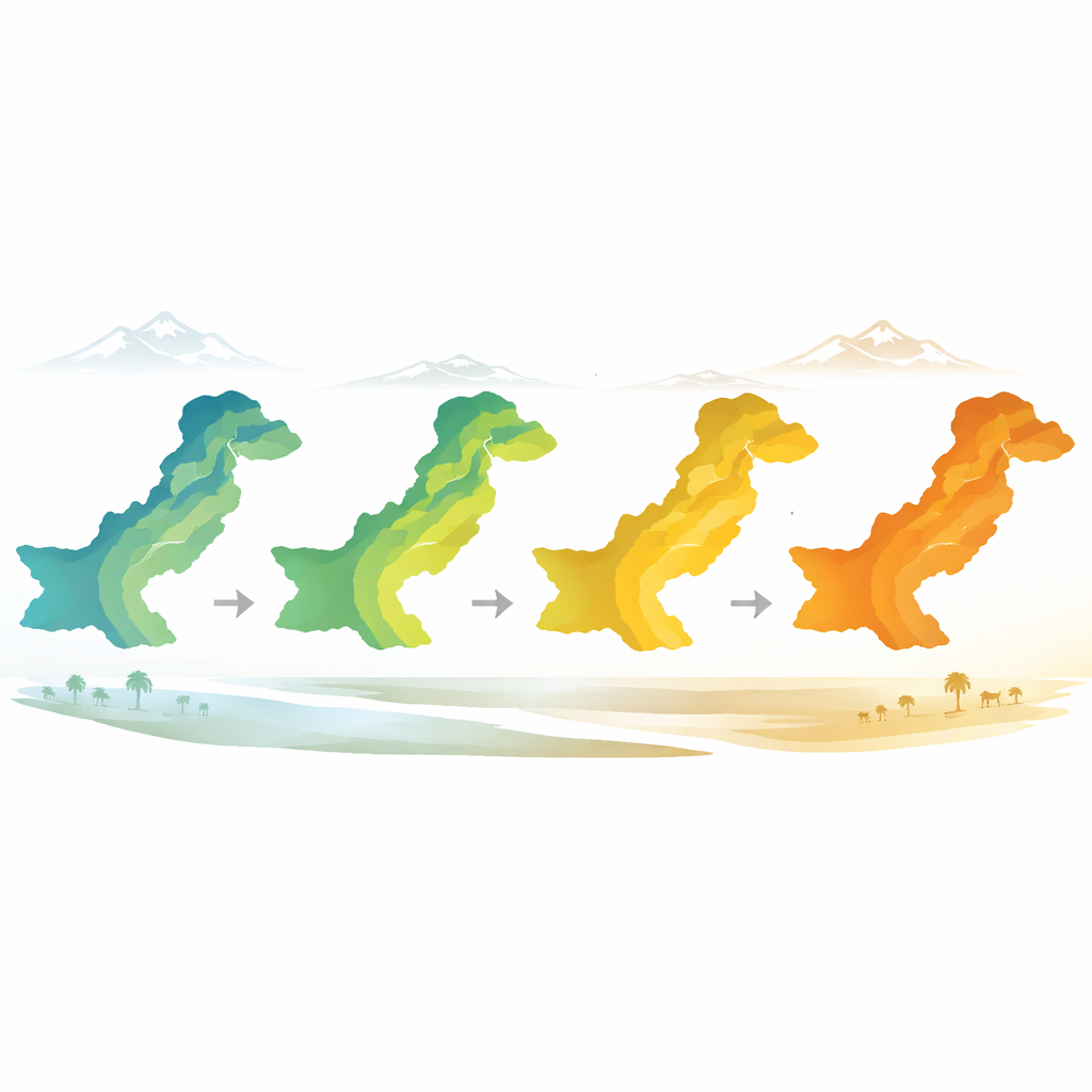
Pakistan’s natural cooling system under strain
Evapotranspiration patterns tie these changes together. In 1989 and 2009, large parts of the northern highlands and some irrigated and coastal areas showed high daily water loss, consistent with healthy vegetation, moist soils, and strong evaporative cooling. By 2019, however, zones with very high and high evapotranspiration had shrunk sharply, while areas with low and very low values had expanded to cover more than half the country. Dry western plateaus remained persistently low, but worrying declines also appeared in agricultural heartlands and along the coast, where wetlands and mangroves have been disturbed. Urban and peri‑urban districts stood out as hotspots where vegetation loss and hard surfaces have reduced natural cooling, amplifying local heat.
What this means for people and planning
For a lay reader, the takeaway is straightforward: Pakistan’s landscape is losing some of its ability to cool itself and recycle water back to the air. Rising surface temperatures, thinning vegetation, darker land surfaces, and shrinking high‑evapotranspiration zones together point to growing stress from urban growth, land degradation, and climate extremes. The study shows that satellite‑based tools like SEBAL can reliably track these changes even where ground measurements are scarce. By weaving this information into water policy, city design, and farming strategies, planners can better target tree planting, protect key ecosystems, and fine‑tune irrigation to conserve water and ease dangerous heat. In essence, keeping Pakistan’s green and wet surfaces alive is not only an environmental concern—it is a practical way to safeguard food, health, and comfort in a warming world.
Citation: Islam, A., Ali, S.M., Alamery, E.R. et al. Modeling evapotranspiration in diverse climatic zones of Pakistan using Surface Energy Balance Algorithm for Land (SEBAL) through geospatial technologies. Sci Rep 16, 10303 (2026). https://doi.org/10.1038/s41598-026-39756-1
Keywords: evapotranspiration, remote sensing, urban heat, Pakistan climate, water management