Clear Sky Science · en
The distribution pattern of the fault karst water flow system in the Baotu spring Basin, Shandong, China
Why the Springs of a City Matter
In the heart of Jinan, a city in northern China famous for its clear, bubbling springs, the real drama happens underground. Those iconic springs depend on hidden rivers of groundwater that wind through fractured and dissolved rock. This study explores how major cracks in the earth’s crust, called faults, and dissolved passageways in limestone, called karst, work together to guide groundwater to the Baotu Spring group—and how the same pathways could also carry pollution toward the city. By decoding this invisible plumbing system, the researchers provide clues for keeping Jinan’s springs flowing and its drinking water safe.
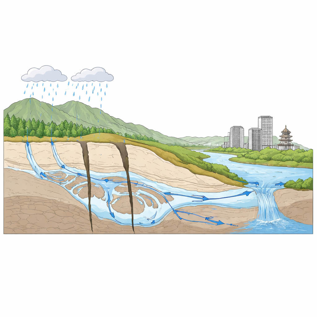
The Hidden Landscape Below the City
Beneath the Baotu Spring Basin lies a thick stack of ancient limestone and dolomite bedrock that has been slowly dissolved by slightly acidic rainwater over millions of years. This process has carved out a complex network of pores, fractures, and underground channels. Large faults slice through these rocks, acting either as tight barriers or open conduits. Together they create a three-part pattern: rain and snow soak into the ground in the higher southern mountains, water moves underground through a central zone where faults and karst features guide flow, and finally groundwater rises and discharges as springs in the lower northern plain. The study shows that this overall pattern—southern recharge, central runoff, northern discharge—forms the backbone of the local water supply system.
The Chemistry That Tells a Story
To understand how water moves through this hidden network, the team collected more than 200 water samples from springs, wells, and surface streams between 2014 and 2021. They measured dissolved ions such as calcium, magnesium, bicarbonate, and sulfate. Across karst groundwater, pore water in loose sediments, and surface water, calcium was the dominant positively charged ion, while bicarbonate and sulfate were the main negatively charged ions. Total dissolved solids were moderate and fairly stable, with only small year‑to‑year fluctuations. These signatures point to a simple but powerful process: water picking up minerals as it weathers and dissolves the surrounding rock. Carbonate minerals like calcite and dolomite are mostly saturated—meaning they are close to their dissolution limit—while salts such as gypsum and halite tend to keep dissolving, slowly feeding sulfate and other ions into the water.
How Faults Reshape Underground Flow
Chemistry alone cannot show where the water travels, so the researchers built a detailed three‑dimensional computer model of the basin using borehole records, maps, and elevation data. They used specialized groundwater software to simulate how water moves through 13 rock layers down to 600 meters. After carefully tuning the model to match measured water levels, they found that groundwater generally flows from the higher southeast toward the lower northwest. But the faults make that journey far from simple. The Qianfoshan Fault blocks flow in its southern segment but allows water through in the north, bending and diverting underground streamlines. The Chaomidian Fault, by contrast, is highly permeable along its length, drawing in water from both sides like a drain and forming a corridor of concentrated flow. These structures turn the basin into a series of connected but distinct zones with different speeds and paths of groundwater movement.
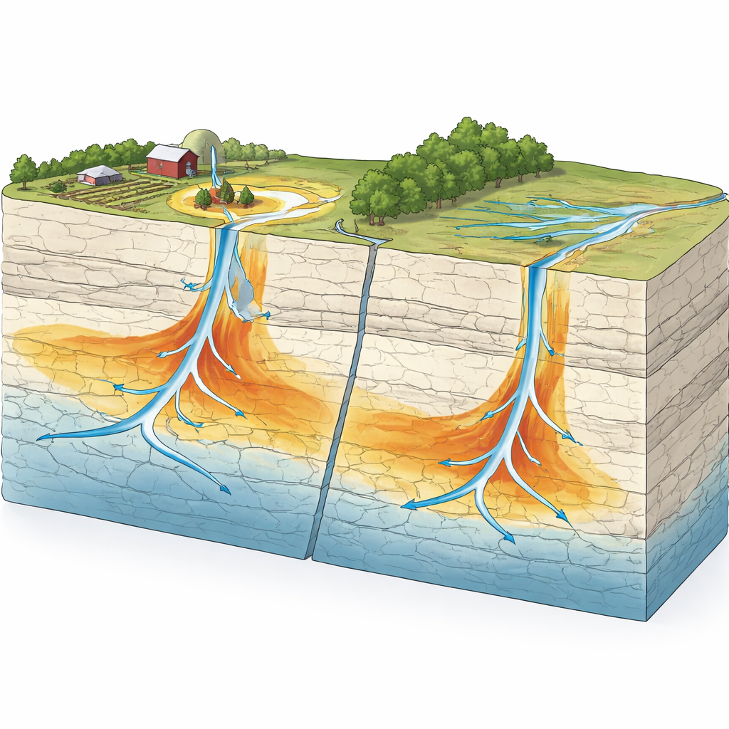
Tracking an Invisible Pollutant
To explore how contamination might spread through this system, the team used nitrate—common in fertilizer and wastewater—as a stand‑in pollutant in their model. They introduced continuous nitrate sources near the major faults and watched how the simulated pollution plumes evolved over 20 years under different fault permeabilities. When the Chaomidian Fault was highly conductive, the plume spread quickly and widely along the fault‑related channels. Along the Qianfoshan Fault, the northern permeable segment allowed the plume to advance, while the southern tight segment acted as a barrier, preventing movement across it. In every scenario, as long as there was a difference in water pressure to drive flow, the plumes continued to grow over time, even when overall permeability was modest. This highlights how faults can both focus and confine pollution, creating narrow but far‑reaching risk zones.
What This Means for Springs and People
Viewed together, the chemistry and modeling results paint a clear picture for non‑specialists: Jinan’s famous springs are fed by a robust, fault‑guided groundwater system whose main directions of flow are stable over time, but whose detailed pathways are highly sensitive to the structure and permeability of faults and karst channels. The same features that deliver clean mountain water to the springs can also speed up the travel of pollutants if they enter the system. By identifying where the key recharge zones lie, how major faults steer water, and where pollution plumes are most likely to spread, this study offers a scientific roadmap for protecting spring flows, setting safer land‑use practices, and planning long‑term groundwater management in Jinan and similar karst regions worldwide.
Citation: Gang, S., Jia, T., Deng, Y. et al. The distribution pattern of the fault karst water flow system in the Baotu spring Basin, Shandong, China. Sci Rep 16, 9857 (2026). https://doi.org/10.1038/s41598-026-39308-7
Keywords: karst groundwater, fault-controlled flow, Baotu Spring, nitrate pollution, numerical modeling