Clear Sky Science · en
A 10 m High-precision Canopy Height Product for Nanping City, Fujian Province, China
Why tree height from space matters
How tall are the trees that protect our climate and our water? In the mountains of Nanping, a forest rich city in southeastern China, the answer is surprisingly hard to pin down. This study shows how scientists combined satellites, drones, and smart computer methods to build a detailed map of forest height, giving local managers a much clearer picture of how much carbon these forests can store and how healthy they really are.
A mountain city wrapped in forest
Nanping City lies in the rugged hills of northern Fujian Province and is often described as a natural shield for southern China. More than three quarters of its land is covered by forest, dominated by evergreen broadleaf trees with patches of planted conifers and bamboo. The terrain is steep, the climate is hot and humid, and the region has been repeatedly disturbed by typhoons, pests, and logging. All of this creates a patchwork of tree heights across the landscape and raises the risk of soil erosion and habitat degradation. Yet traditional field surveys cannot keep up: they are accurate but slow, expensive, and cover only small areas, leaving big gaps in knowledge about how these forests are changing year to year.
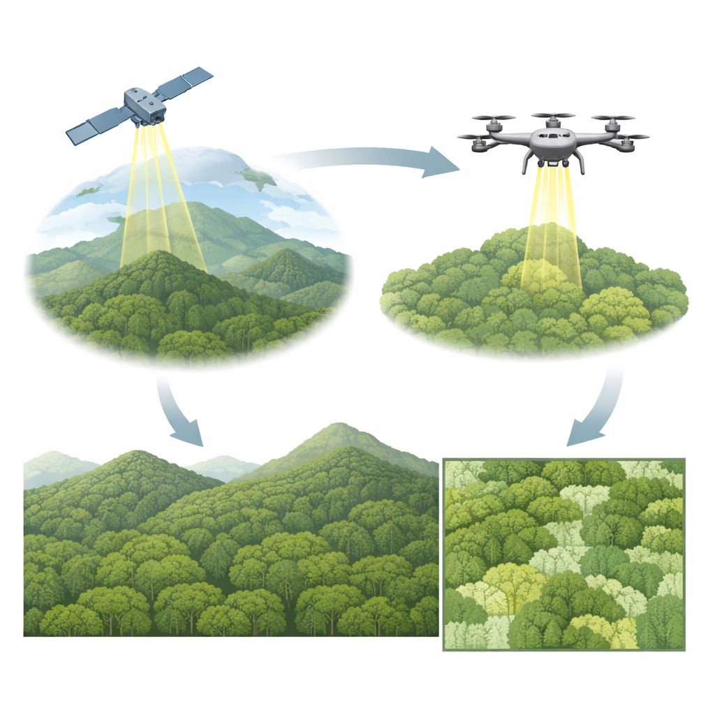
Seeing forest height from above
To fill these gaps, the team turned to a space based laser instrument called GEDI, which beams pulses of light down from the International Space Station and records how they bounce off leaves and the ground. This reveals the vertical profile of the forest, including tree height, at billions of locations between roughly 50 degrees north and south. On its own, however, GEDI still makes systematic mistakes, especially in tall or very dense forests and in steep mountains, where it can underestimate or overestimate height by several meters. The researchers addressed this by pairing GEDI data with extremely detailed measurements from drone mounted laser scanners that flew over 30 sample plots in Nanping during 2022 and 2023. These drone surveys produced near ground truth maps of tree height at one meter resolution.
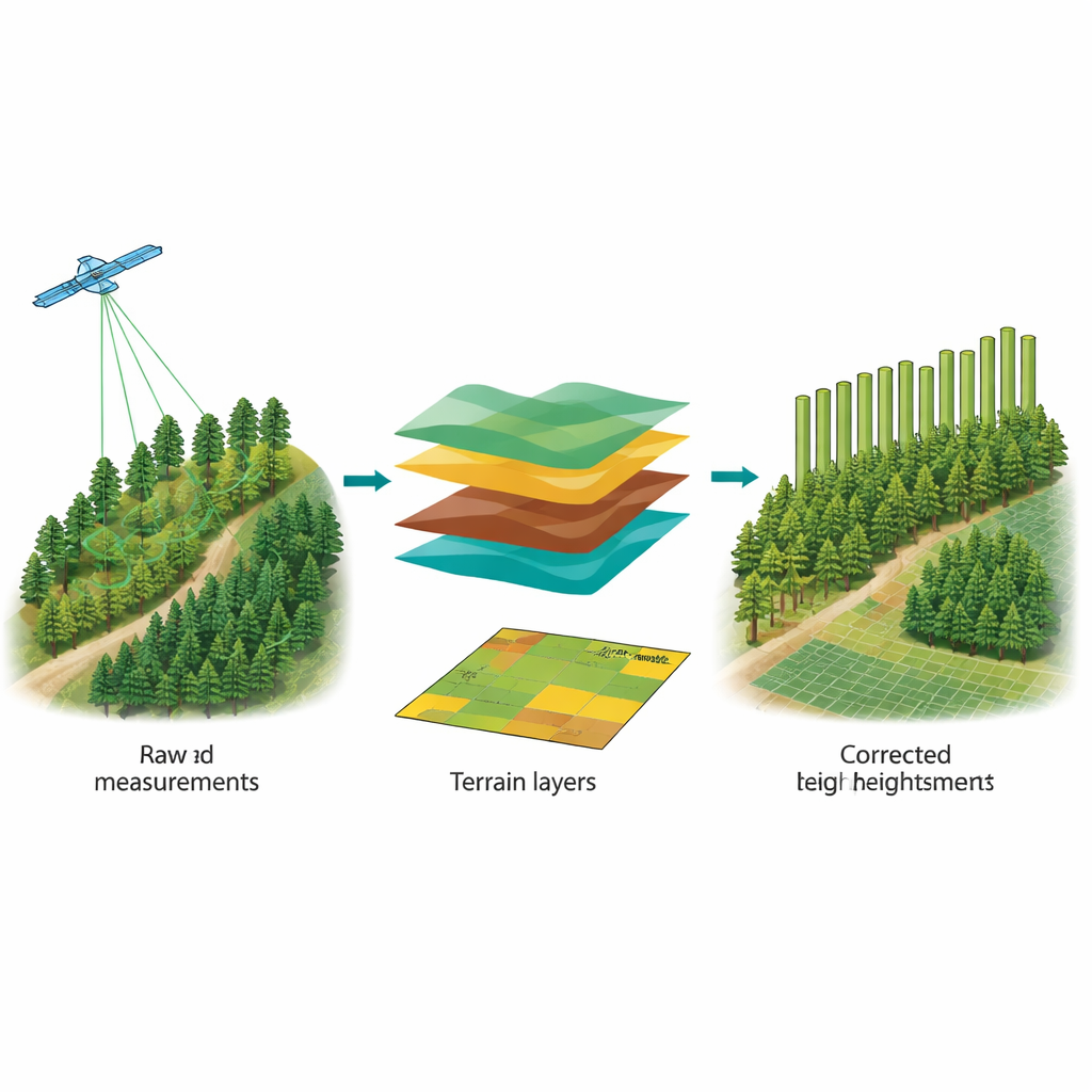
Teaching the data to correct itself
Using the drone measurements as a trusted reference, the scientists built a bias calibration model designed to learn how GEDI tends to err under different conditions. They fed the model both the original GEDI height estimates and local terrain information such as elevation, slope, aspect, and shading derived from a high resolution elevation map. The model, based on a random forest algorithm, learned to predict a corrected height value for each GEDI footprint. After this step, the agreement between GEDI and drone data improved dramatically: the typical error dropped from nearly 12 meters to less than 2 meters, and the systematic overestimation almost disappeared, even in the complex highland areas.
Turning points into a wall to wall map
Corrected GEDI points on their own still cover only narrow tracks, so the next challenge was to fill in the gaps between them. To do this, the team combined the calibrated GEDI heights with a rich set of satellite based clues about forest conditions. They used optical images from Sentinel 2 to capture vegetation color and greenness, radar images from Sentinel 1 to sense structure and moisture, and climate and land cover data to provide context on temperature, rainfall, and forest type. From these sources they built twelve key features, including improved vegetation indices and texture measures that describe how rough or smooth the forest appears. A second random forest model then learned how these features relate to tree height and used that relationship to estimate height every 10 meters across all of Nanping for both 2022 and 2023.
What the new maps reveal
The finished products are freely available 10 meter resolution maps of canopy height for the entire city. Independent checks against drone plots that were not used in training show that the maps capture real tree heights with errors of about three meters, a major improvement over earlier regional and global products. Most of Nanping’s forests are between 10 and 20 meters tall, with relatively few stands over 20 meters. Between 2022 and 2023, average canopy height increased by roughly 40 centimeters, a modest but detectable rise consistent with ongoing growth and local changes. Although some uncertainty remains, especially in the tallest stands and in very rugged terrain, these maps provide a robust foundation for estimating forest biomass, tracking disturbance, and planning more precise forest management.
What this means for people and climate
For non specialists, the main takeaway is that we can now see the structure of Nanping’s forests in far greater detail than before by fusing space based lasers, drones, and satellite imagery. This gives scientists and local agencies a much sharper tool for estimating how much carbon these forests hold, how well they protect soil and water, and how they respond to storms, pests, and human use. The same approach can be extended to other mountainous, forest rich regions, turning scattered measurements into clear, city wide pictures of forest health that can guide smarter conservation and climate policy.
Citation: Yi, L., Yao, X., Yang, A. et al. A 10 m High-precision Canopy Height Product for Nanping City, Fujian Province, China. Sci Data 13, 710 (2026). https://doi.org/10.1038/s41597-026-06767-6
Keywords: forest canopy height, remote sensing, GEDI lidar, Nanping Fujian, carbon stock mapping