Clear Sky Science · en
Anatomy of a post-subduction collision
Why this hidden deep Earth story matters
Across the Middle East and Caucasus, mountains rise, basins sink, and volcanoes erupt in patterns that seem puzzling when viewed only from the surface. This study peels back the crust to show how slow, unseen flows of hot rock deep inside Earth help shape this restless landscape today. By exploring the collision between the Arabian and Eurasian continents, the authors reveal how a narrow stream of buoyant mantle material helps control where mountains grow, where earthquakes strike, and where new volcanoes appear.
The meeting of two giant plates
The Arabian plate has been slowly pushing into Eurasia for millions of years, closing the long-vanished Neotethys Ocean. This collision built high plateaus in eastern Türkiye, Armenia, Georgia, and Iran, and created long belts of folded rocks such as the Zagros Mountains. At the same time, large basins like the Mesopotamian, Kura, and Caspian regions have sagged and filled with thick sediments. Seen from the surface, the region looks like a jumble of mountains, volcanoes, and deep depressions, but their true connection lies far below in the upper mantle, where former oceanic slabs continue to sink and interact with rising hot material.
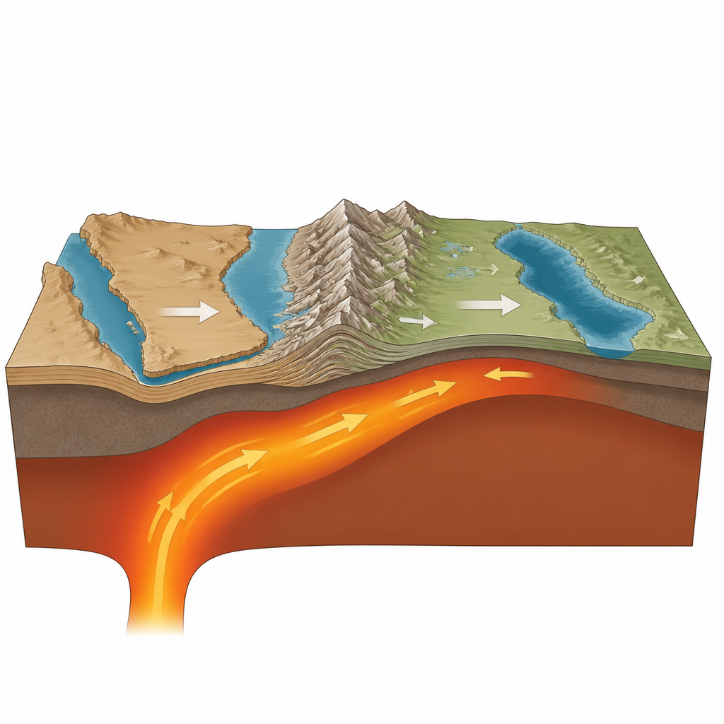
A narrow mantle stream under the collision
Using three dimensional computer models guided by seismic images of Earth’s interior, the authors focus on a narrow zone of hot, weak mantle that they call a plumelet. Unlike the classic mushroom shaped plumes sometimes invoked under hotspots, this plumelet behaves more like a sideways river of soft rock. It rises beneath the Arabian foreland, then sweeps northeastward under the collision zone toward the Greater Caucasus. As it travels, it threads its way through a maze of cooler, denser slabs left over from the former ocean floor, bending and eroding them from below. This deep stream exerts an upward push on some parts of the crust while allowing others to sink, helping to explain why nearby regions can show high mountains next to deep basins.
Mountains, basins, and volcanoes as surface clues
The models show that where the plumelet passes beneath volcanic plateaus such as the Turkish Georgian Armenian highlands and the East Anatolian and North Iranian plateaus, it heats and thins the lower crust and uppermost mantle. This extra buoyancy adds several hundred meters of support to the surface, helping these areas stand high even where the crust is not especially thick. In contrast, places with cold, dense roots, like the Kura, Terek, and Zagros basins, experience a downward pull that deepens them. The same mantle flow also promotes drip like removal of dense material beneath parts of the former magmatic arc in the southern Caucasus, turning an old subduction zone into an intraplate style volcanic region.
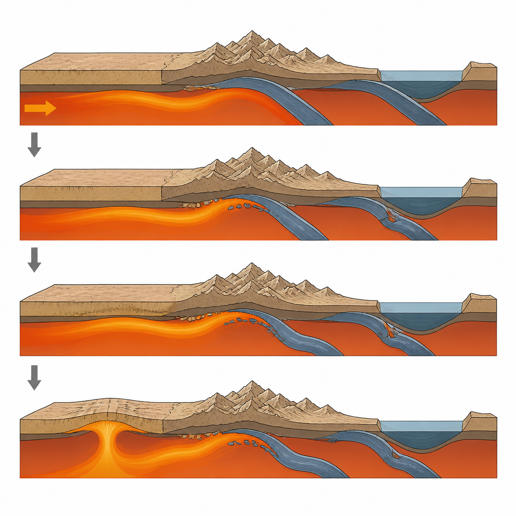
Hidden tears and changing earthquake patterns
A key result of the work is the discovery of previously unrecognized breaks and tears in the old Neotethyan slabs beneath the collision zone. The Bitlis and Zagros slabs are not continuous sheets; they are segmented and in places detached, with pieces sinking beneath the Arabian plate while others are actively tearing near the Greater Caucasus. The plumelet interacts differently with these fragments from west to east, helping to channel deformation and to partition where earthquakes occur. In zones where the upper plate is being stretched and torn above cold slab fragments, subcrustal earthquakes cluster, whereas in the plumelet fed low viscosity channel to the west, deformation is mostly smooth and aseismic.
A new picture of how deep flow shapes a collision
By tying together seismic data, surface topography, and numerical simulations, the study builds a coherent picture of the Arabian Eurasian collision in which a narrow mantle stream plays a starring role. Rather than slabs alone controlling the story, this plumelet reshapes the base of the plates, guides where the crust thickens or thins, and even helps determine where faults slip and volcanoes erupt. For a lay reader, the takeaway is that the dramatic mountains and destructive earthquakes of this region are not just the result of plates crashing together at the surface, but also of a long lasting underground current that continues to rework the deep roots of the continents.
Citation: Şengül Uluocak, E., Pysklywec, R.N., Faccenna, C. et al. Anatomy of a post-subduction collision. Nat Commun 17, 4484 (2026). https://doi.org/10.1038/s41467-026-70008-y
Keywords: Arabia Eurasia collision, mantle flow, subduction slabs, plateau uplift, continental tectonics