Clear Sky Science · en
Spaceborne snapshot compressive hyperspectral imaging
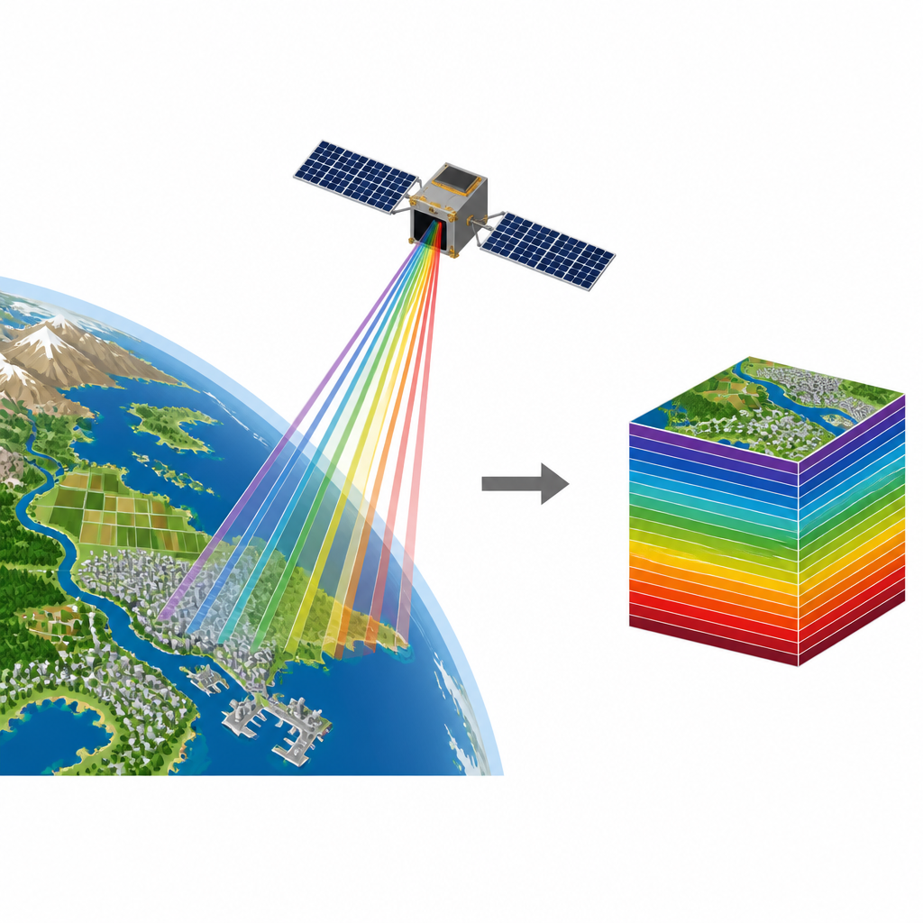
Watching Earth in New Colors
Imagine a camera in space that can tell the difference between healthy crops and polluted water just by the subtle colors of reflected sunlight, and can do it fast enough to make a movie. This paper presents such a system: a backpack-sized instrument on a satellite that takes “color-rich” snapshots of Earth in dozens of invisible shades at once, while keeping the hardware small and the data manageable.
Why Extra Colors Matter
Ordinary satellite images capture just a few broad colors, similar to the red, green, and blue channels in your phone camera. Hyperspectral imaging goes much further, recording tens of very narrow color bands across the visible range. Each material on the ground, from asphalt to algae, has its own subtle color fingerprint across these bands, which allows scientists to distinguish different types of plants, soils, buildings, and water conditions. This makes hyperspectral data powerful for jobs like tracking wildfires, monitoring air and water quality, mapping minerals, and supporting farming and urban planning.
Old Tools and Their Limits
Traditional spaceborne hyperspectral cameras typically scan the ground line by line or rely on filters that sample different colors at slightly different times. These approaches demand large, complex optics and generate huge volumes of data. Because the satellite and Earth are moving relative to each other, fast-changing targets can shift between color captures, making it harder to align the information. At the same time, storing and transmitting such rich data strains satellite memory and radio links, and slow scanning makes it difficult to obtain video-like views of dynamic events such as storms, smoke plumes, or moving ships.
A Compact Camera with Smart Coding
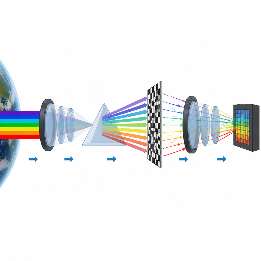
The authors built a new payload called BUPT-spectra01 that tackles these challenges by blending clever optics with modern computation. Instead of recording every color channel separately, the instrument uses a compact layout with lenses, a prism, and a reflective patterned mask to mix information from 47 color bands into a single two-dimensional exposure. The prism spreads incoming light by color, the mask imprints a known pattern on the light, and the optical path is folded so the same components are reused, saving size and weight. A sensitive sensor then records one coded snapshot, and a specially designed spatial-spectral inference neural network decodes that snapshot into a full hyperspectral data cube on the ground.
Built to Survive Space and Work in Real Time
To operate from 520 kilometers above Earth, the team had to ensure sharp focus, low image distortion, and mechanical stability under launch vibration, vacuum, and temperature swings. They designed custom lens groups to reduce blurring and warping, coated glass elements to favor the desired wavelengths, and added stray-light traps to avoid unwanted reflections. Ground tests showed that the camera could accurately reconstruct both fine details and color fingerprints when compared with a laboratory spectrometer. Vacuum and vibration trials confirmed that focus shifts and component movement stayed within tight limits, meaning the coded patterns and measurements remain reliable once in orbit.
Seeing Cities and Coasts in Motion
In orbit, BUPT-spectra01 captured detailed hyperspectral images over cities such as Abu Dhabi and Montevideo, with each snapshot covering tens of kilometers at about 50 meters resolution. Using simple clustering methods, the researchers could separate sea, shallow water, different land surfaces, and city areas based on their spectral signatures, achieving high classification accuracy when compared with maps built from high-resolution imagery. The system can also operate at 30 frames per second, enabling hyperspectral video of coastlines and urban regions, where the spectral fingerprints of water and land remain consistent over time while scenes change.
What This Means for Everyday Life
For a non-specialist, the main message is that a small, efficient satellite camera can now capture rich “beyond-RGB” movies of Earth’s surface while compressing the data as it is collected. This opens the door to more frequent and widespread hyperspectral coverage, even on small satellites, which can help track disasters, follow environmental changes, and manage natural resources with finer detail and greater timeliness. As this technology is refined and deployed in constellations, it could become a routine part of how we watch and care for our planet.
Citation: Yu, Z., Cheng, L., Ma, J. et al. Spaceborne snapshot compressive hyperspectral imaging. Light Sci Appl 15, 234 (2026). https://doi.org/10.1038/s41377-026-02296-4
Keywords: hyperspectral imaging, Earth observation, satellite remote sensing, computational imaging, spaceborne sensor