Clear Sky Science · en
Enhancing ancient human ruins classification with residual neural networks using visible near-infrared spectra
Why buried cities still matter today
Across the world, traces of long-vanished towns and fields lie hidden beneath our feet, blurred into ordinary soil by thousands of years of wind, water, and farming. These buried remains hold clues to how earlier societies adapted to climate shifts, floods, and population booms—problems that echo our own. Yet finding such subtle ruins is painstaking work that often depends on a skilled eye at a dig site. This study explores how beams of visible and near-infrared light, paired with modern artificial intelligence, can turn nondescript dirt into a rich map of past human activity, speeding up discoveries while cutting cost and guesswork. 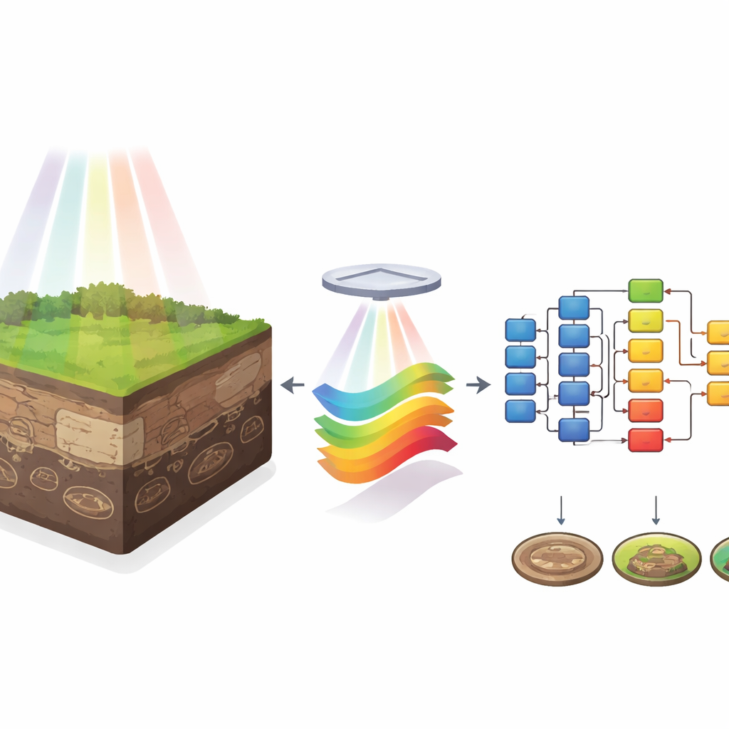
Looking for traces in ordinary ground
Ancient human ruins are not always grand temples or city walls. Many are ash pits, graves, defensive ditches, compacted earthen walls, or piles of broken building materials that, over time, blend into surrounding sediments. Traditional surveys and even satellite images struggle to distinguish these features from natural soils when they are small or deeply buried. Central China, a cradle of Chinese civilization with five millennia of nearly continuous settlement, provides a perfect testbed. There, farmers and rivers have repeatedly reshaped the land, leaving a complex patchwork of cultural deposits—such as moats and rammed-earth platforms—interleaved with loess, paleosols, and lakebed sediments.
Turning light into fingerprints of the past
To capture subtle differences between these materials, the researchers collected more than 14,000 spectral samples at 27 archaeological sites across Central China. Using a field spectrometer under clear midday skies, they measured how each type of soil or ruin reflected light across hundreds of narrow wavelength bands, from visible colors into the near-infrared. Each sample thus became a kind of optical fingerprint, shaped by its grain size, moisture, organic content, and mineral makeup. The team focused on eight categories: ash pits, burials, moats, rammed-earth constructions, architectural debris, loess, paleosols, and lacustrine (lake) sediments. Spanning cultures from early Neolithic villages to early imperial China, these samples capture both human activity and varied natural settings.
Cleaning the signal and teaching the machine
Raw spectral data are messy. Water vapor in the atmosphere introduces noisy bands; instrument quirks, lighting shifts, and uneven grain size further cloud the picture. The team first removed heavily distorted wavelength regions and then tested three mathematical techniques for cleaning the remaining curves. One, called Standard Normal Variate (SNV), rescales each spectrum to reduce the influence of scattering and grain-size differences. Another, Multiple Scattering Correction, separates light absorbed by the material from light scattered by particles. After preprocessing, each one-dimensional spectrum was reshaped into a small 39-by-39 grayscale image, treating the spectral curve as a texture that a computer can recognize. The researchers then trained several deep learning models—including AlexNet, MobileNetV2, and a deeper residual network known as ResNet50—to classify these images into the eight ruin and sediment types. 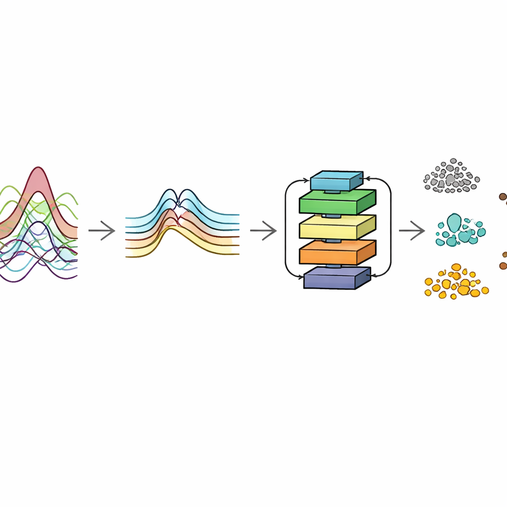
How well the smart classifier performs
The standout performer was the combination of SNV preprocessing with the ResNet50 network. This pairing reached an overall classification accuracy of about 96.6 percent, outperforming the same network without preprocessing and the other neural models. It proved especially strong at telling apart materials that look similar to the naked eye, such as different buried sediments. Even when the researchers reduced the amount of training data to only 40 percent of the available samples, accuracy remained above 93 percent, climbing steadily as more examples were added. Confusion-matrix analyses showed that some categories, such as lacustrine sediments and loess, were identified with particularly high reliability, while even the hardest class—architectural debris—still achieved accuracy above 95 percent.
What this means for archaeology and beyond
For non-specialists, the key result is simple: by shining a broad spectrum of light on soil and letting a tuned neural network interpret the reflections, archaeologists can rapidly and objectively map where people once lived, farmed, and built—even when no walls or artifacts are visible. This method reduces reliance on personal experience, accelerates field surveys, and opens the door to large-scale, semi-automatic scans of landscapes in search of subtle cultural traces. Although the current dataset is tailored to the climate and history of Central China, the same approach can be extended to other regions and time periods as more spectral libraries are built. In the long run, combining hyperspectral sensing, artificial intelligence, and other remote tools may transform how we explore buried histories, giving us sharper insight into how earlier societies coped with environmental change—and how we might do the same.
Citation: Luo, R., Chen, P., Wang, H. et al. Enhancing ancient human ruins classification with residual neural networks using visible near-infrared spectra. npj Herit. Sci. 14, 284 (2026). https://doi.org/10.1038/s40494-026-02564-x
Keywords: hyperspectral archaeology, ancient human ruins, deep learning, near-infrared spectra, heritage detection