Clear Sky Science · en
Site-specific location calibration and validation of ray-tracing simulator NYURay at upper mid-band frequencies
Why this matters for everyday connectivity
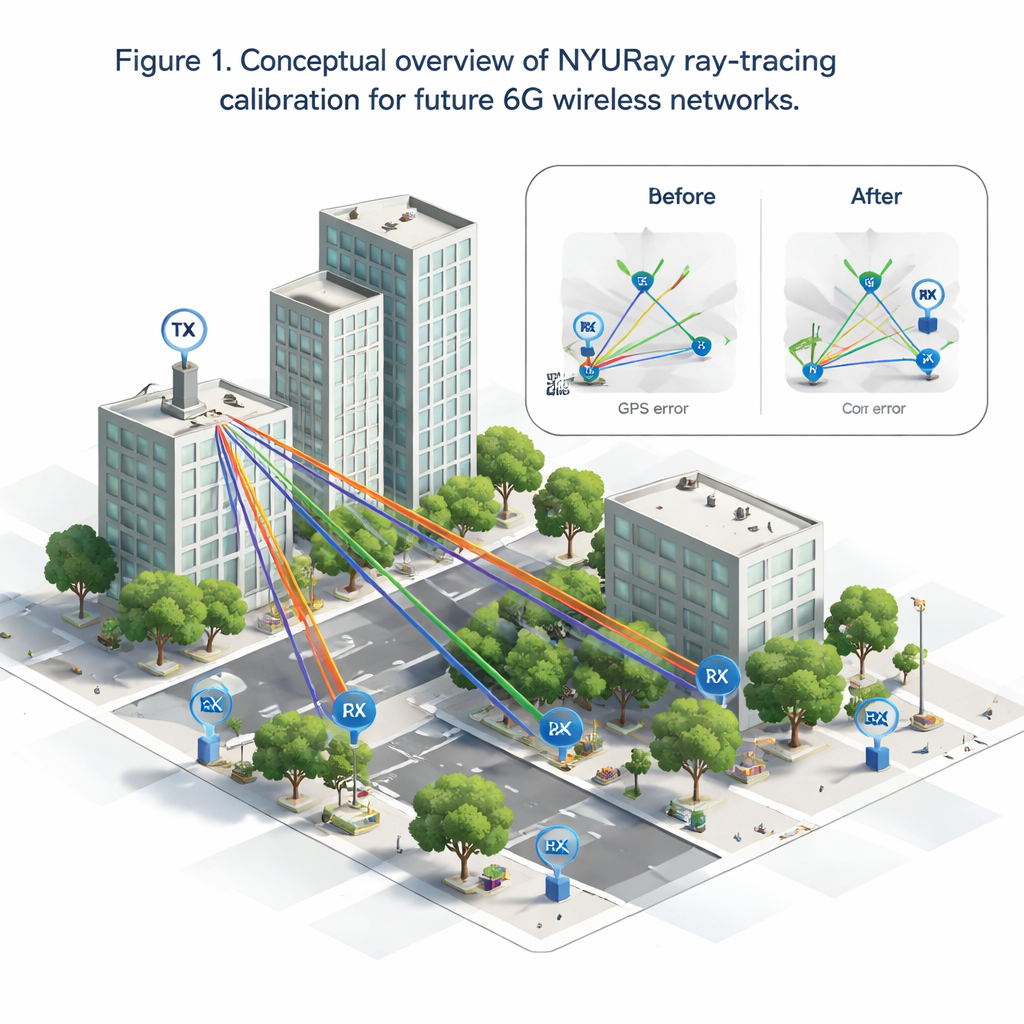
As our phones, cars, and factories rely on ever-faster wireless links, engineers need a way to test future networks without rebuilding a city every time. This paper describes how researchers turned a detailed 3D digital copy of downtown Brooklyn into a "radio twin"—a simulator called NYURay that predicts how signals really travel through streets and around buildings at key 6G frequencies, and how they fixed hidden GPS errors that usually throw such simulations off.
Building a digital city for radio waves
To make trustworthy predictions, the team first constructed a highly accurate 3D model of the NYU Brooklyn campus area. They started with open map data, then went outside with laser rangefinders and phone-based LiDAR scanners to measure building heights, lamp posts, benches, traffic signs, and even trash bins to within a few centimeters. Each object in this digital city was then tagged with realistic material properties so NYURay could estimate how radio waves at 6.75 and 16.95 gigahertz reflect, pass through, or bend around them—an essential step because, at these frequencies, even modest details can strongly affect signal strength.
From theory to realistic signal paths
Inside this virtual city, NYURay traces many possible paths that a radio signal might take from a base station on a lamppost to a user on the sidewalk or down the street. It includes four key behaviors: reflections from walls and the ground, limited transmission through materials, bending around building edges, and, when appropriate, scattering from rough surfaces. For each path, the simulator computes how far the wave travels, how much it weakens, and when it arrives. By adding all these paths together, NYURay produces a “power–delay profile,” a kind of fingerprint showing how signal energy is spread out in time—something that can be measured in the real world with specialized test equipment.
Fixing the hidden problem of fuzzy locations
A major obstacle to matching simulations with reality is that field measurements often rely on standard GPS, which can be off by 5 to 10 meters in city streets. At the frequencies studied here, such errors can completely change which buildings a signal bounces off, making a good simulator look wrong. The researchers created a location calibration algorithm that gently shifts the transmitter and receiver positions—within the known GPS error range—until the simulated and measured power–delay profiles line up as closely as possible. Using a mix of coarse grid search and fine, derivative-free optimization, they cut position errors down to below one meter on average and significantly improved how well key signal peaks matched in time and power, especially when there was a clear line of sight.
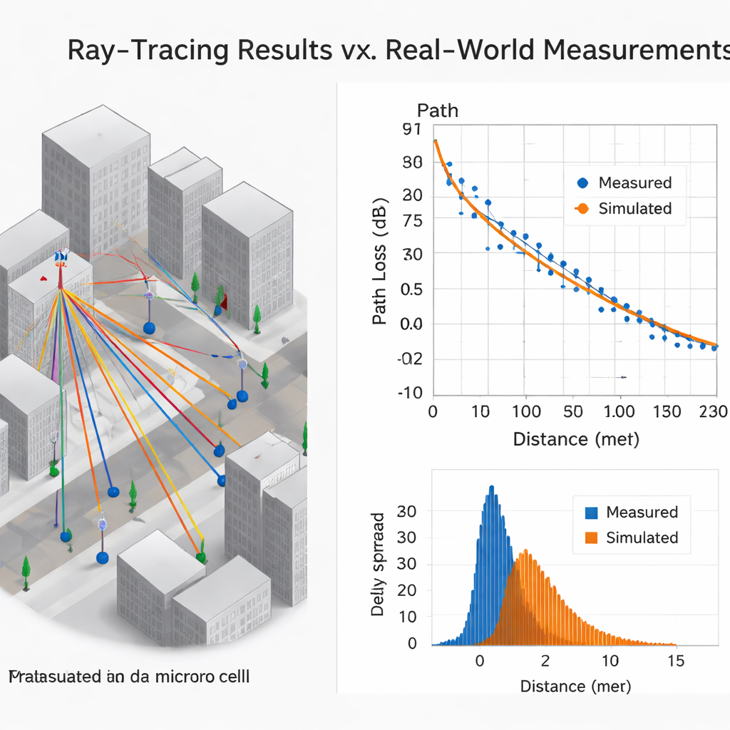
How well the digital twin matches the real city
Armed with calibrated locations, the team compared NYURay’s predictions to detailed measurements at 18 transmitter–receiver pairs spanning 40 to 880 meters, covering both open squares and typical city streets. For large-scale behavior—how quickly signals fade with distance—the agreement was excellent: the simulator’s path loss exponents differed from measurements by at most 0.14, and closely tracked industry-standard 3GPP models. Where the digital twin fell short was in “multipath richness,” the fine-grained spreading of signals over time and angle caused by countless small reflectors and moving objects like cars and pedestrians. Because the 3D model does not include every window frame and tree branch, and the simulation assumes a static scene, NYURay systematically underestimated delay spread and angular spread compared with what the measurement teams saw in the real streets.
What this means for future wireless networks
For practical 6G planning—like deciding where to put small base stations or estimating coverage and interference—this study shows that a carefully calibrated ray-tracing engine such as NYURay can already provide highly reliable answers. It captures how signals weaken with distance and how they bend around major obstacles in a realistic city, and it can be tuned to correct for imperfect GPS logs in long-running measurement campaigns. At the same time, the observed gaps in fine multipath detail highlight where future tools must improve, by adding richer environmental detail and smarter models of moving people and vehicles. Together, these advances move us closer to trustworthy wireless “digital twins” that let engineers experiment with tomorrow’s networks entirely in software before a single antenna goes up.
Citation: Ying, M., Shakya, D., Ma, P. et al. Site-specific location calibration and validation of ray-tracing simulator NYURay at upper mid-band frequencies. npj Wirel. Technol. 2, 8 (2026). https://doi.org/10.1038/s44459-025-00014-x
Keywords: ray tracing, 6G wireless, radio propagation, digital twin, urban microcell