Clear Sky Science · en
Ice-patch collapse and early-warning implications from a Himalayan flash flood: emerging cryo-hydrological hazards under deglaciation
Why a Hidden Ice Patch Matters to Mountain Villages
High in the Indian Himalaya, far above the tree line, a small, hidden patch of ice suddenly collapsed in August 2025. Within minutes, a wall of water, mud, and boulders tore through the village of Dharali, destroying homes and shops along a narrow mountain stream. This study explains how such a seemingly modest feature—an exposed ice patch rather than a large glacier or lake—can unleash a deadly flash flood, and how satellites and terrain data could help spot similar threats before they strike. 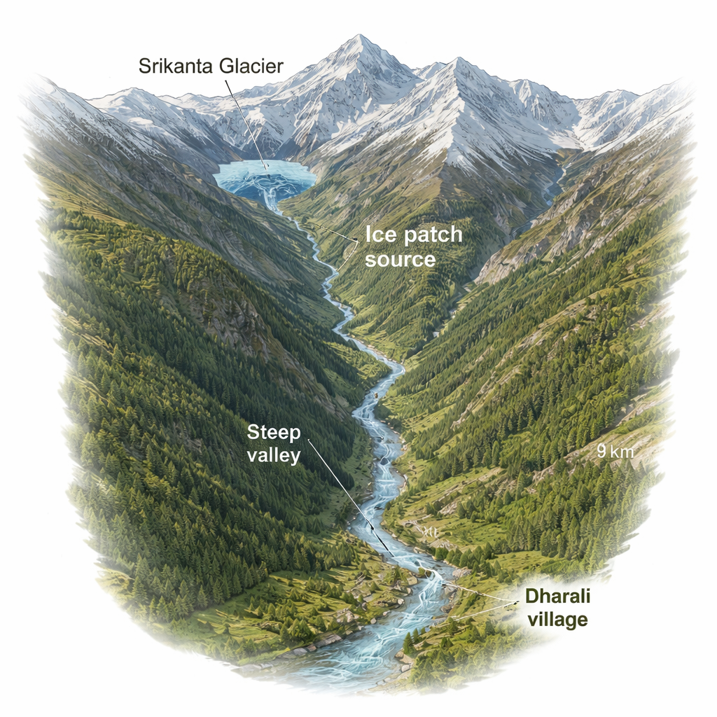
A Steep Valley and a Vulnerable Village
Dharali sits in a classic Himalayan setting: a small settlement on the floor of a deep, V-shaped valley, straddling a glacier-fed stream called Khir Gad just before it joins the larger Bhagirathi River. Above the village rise more than 2.5 kilometers of rugged relief, ending at the Srikanta Glacier and its surrounding snowfields. This steep, continuous ridge-to-valley pathway acts like a giant chute. When anything breaks loose high on the slope—snow, ice, rocks, or water—gravity and narrow channels can rapidly funnel it straight toward the village. Dharali is an important stop for pilgrims and tourists heading toward Gangotri, so any sudden flood here has outsized human and economic consequences.
From Persistent Snow to Exposed Ice
Using almost 15 years of satellite images, the researchers tracked how snow and ice behaved in the shaded "nivation zone" just below the Srikanta ridge. Normally, these hollows stay cloaked in snow even through summer, insulating any buried ice. But in 2025, the pattern changed. Images from April to June showed the usual winter snow retreating. By early July, however, the team detected something new: dark-toned patches of exposed ice sitting on a 25–35 degree north- to northeast-facing slope—evidence that the protective snow cover had thinned under ongoing warming. Just days before the disaster, additional satellite data confirmed there was no fresh snowfall to hide these patches, and weather records ruled out a local cloudburst. That meant a different kind of trigger had to be responsible.
When an Ice Patch Gives Way
After the August 5 flood, fresh satellite images told a stark before-and-after story. One major ice patch—covering about a quarter of a square kilometer—had vanished. In its place, and immediately downslope on even steeper terrain, was a bright, freshly stripped scar, showing where material had been ripped away and swept downhill. By combining high-resolution elevation models with these images, the authors estimated that even a relatively thin ice layer there contained tens of thousands of cubic meters of ice. Dropping more than 1.7 kilometers vertically along a steep, confined channel, that mixture of melting ice, water, and loose sediment had enough gravitational energy to transform into a short, ferocious surge. Public videos from Dharali matched this picture: a brief, fast-moving, debris-rich wave, followed by hours of muddier, lower-intensity flow as the disturbance worked its way downstream. 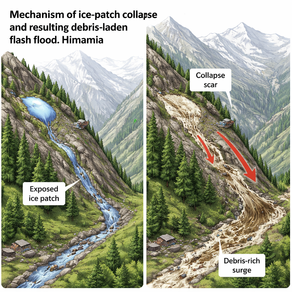
How a Small Source Becomes a Big Disaster
The study shows that in such landscapes, the danger is not just how much water is released, but how fast and where it travels. The steep slopes between the Srikanta nivation zone and Dharali, along with the tightly confined Khir Gad channel, concentrated the flow into a narrow corridor. Along the way, the rushing mixture plucked up rocks, soil, and old landslide debris, turning a limited water and ice volume into a dense, highly erosive torrent. Satellite images taken before and after the flood reveal that the stream channel widened sharply, banks were scoured, and newly exposed surfaces and deposits appeared right where buildings and roads had stood. Ground photos taken by the authors show a once-contained stream transformed into a broad, rubble-choked corridor cutting into the heart of the village.
Spotting the Next Hidden Threat
For a general reader, the crucial message is that Himalayan floods will not always come from obvious sources like overflowing lakes or extreme rainstorms. As glaciers thin and retreat, once-stable snow hollows and buried ice patches can become fragile, especially on steep, shaded slopes. When they suddenly fail, they can send powerful surges racing down to communities in minutes. This research demonstrates that careful monitoring of satellite imagery—looking for newly exposed ice patches in sensitive locations—combined with detailed elevation data can provide early hints of such emerging hazards. In a rapidly warming mountain world, learning to recognize these subtle warning signs could help protect vulnerable villages like Dharali from the next surprise flood.
Citation: Dandabathula, G., Ghatage, O.S., Roy, S. et al. Ice-patch collapse and early-warning implications from a Himalayan flash flood: emerging cryo-hydrological hazards under deglaciation. npj Nat. Hazards 3, 24 (2026). https://doi.org/10.1038/s44304-026-00191-x
Keywords: Himalayan flash floods, glacier retreat, ice patch collapse, mountain hazards, satellite monitoring