Clear Sky Science · en
Tsunamigenic potential of a newly identified intraplate fault on the passive continental margin of the Northwestern South China Sea
Hidden dangers beneath a quiet sea
Many people think of tsunamis as rare giants born only at dramatic plate boundaries like Japan or Indonesia. This study shows that a seemingly calm stretch of ocean—the northern South China Sea, off southern China and Vietnam—also hides the potential for dangerous tsunamis. By uncovering the behavior of a newly recognized underwater fault on this passive margin, the authors reveal that nearby coasts could face powerful waves with only minutes of warning, calling for a rethink of how this region prepares for the sea’s sudden surges.
A quiet edge that is not so safe
The northern South China Sea is usually described as a “passive” margin: there is no major plate collision or active volcanic arc, the continental shelf is broad and shallow, and thick layers of marine mud and sand have gently built up over millions of years. Because of this, attention has long focused on the much more dramatic Manila Subduction Zone farther east, where one tectonic plate dives beneath another and can trigger enormous, ocean-spanning tsunamis. Yet historical accounts from China and surrounding regions describe sudden sea surges, land sinking into the sea, and rapidly rising and falling tides—classic signs of tsunamis—linked to earthquakes that did not come from Manila, hinting that local sources were being overlooked.
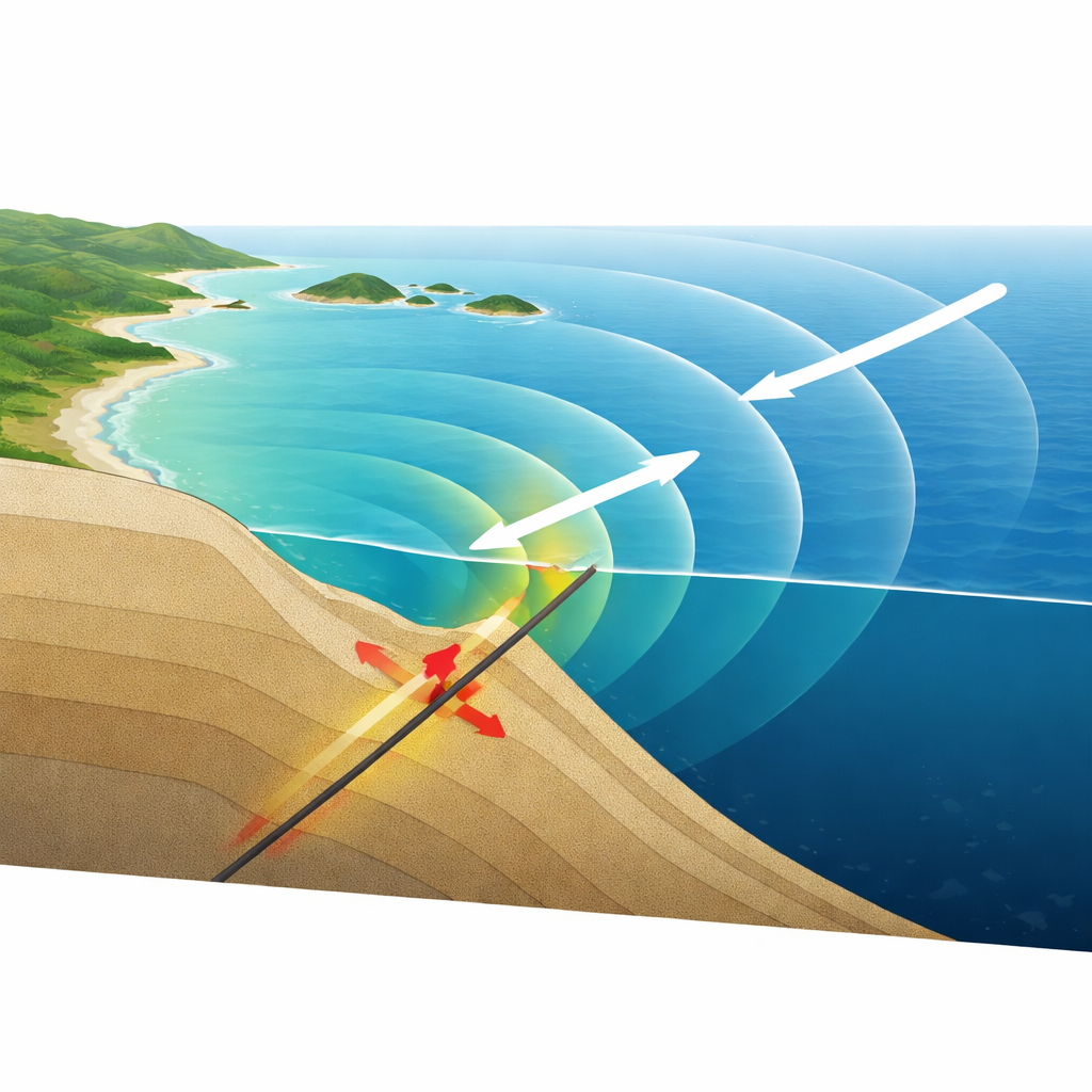
A newly recognized fault under the slope
Recent high‑resolution surveys of the seafloor and underlying rocks have revealed two major fault zones in the northern South China Sea. This study zooms in on the Qiongdongnan segment of the Continental Slope Fault Zone, a steep break in the seabed located near the shelf edge off Hainan Island. Evidence shows this fault has been active in recent geological time. To understand what it could do today, the researchers built about 300 possible earthquake scenarios, varying in strength from moderate to very large and allowing the slip on the fault to be patchy and irregular, as real earthquakes are. They then used a well‑tested tsunami simulation tool to see how the resulting waves would spread across the region’s complex underwater landscape.
How waves travel and where they hit hardest
The simulations show that earthquakes on this slope fault mainly threaten areas within roughly 300 kilometers. Because of the fault’s orientation, most tsunami energy shoots out in directions roughly perpendicular to the fault line, focusing on three key coastlines: the Qiongdongnan coast of China, the Xisha Islands in the central sea, and the central coast of Vietnam. Even for moderate events, these shores can feel noticeable water level changes. For earthquakes stronger than about magnitude 7.4, maximum wave heights commonly exceed one meter along these coasts, and in an extreme magnitude 8.0 case, waves could top 7 meters off Qiongdongnan, 6 meters near the Xisha Islands, and 5 meters along Vietnam. Importantly, the first waves would arrive in just 12–15 minutes near the source, offering very little time for official warnings.
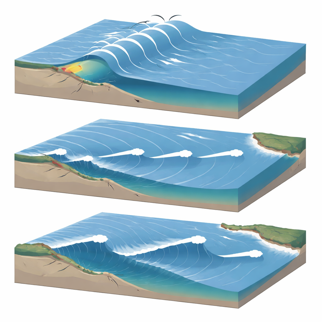
The shaping power of the seafloor
The height and timing of the simulated tsunamis do not simply fade with distance from the fault. Instead, the detailed shape of the seafloor plays a leading role. A prominent underwater ridge acts like a waveguide, bending and concentrating energy toward the Vietnamese coast, boosting hazard there despite its less direct position. Hainan Island blocks and splits northwest‑moving waves, sending some energy toward western Guangdong, where the narrowing continental shelf causes the waves to grow taller, and some toward the Beibu Gulf, where greater energy loss in shallow water keeps them smaller. Meanwhile, areas far to the east—such as Taiwan and Luzon—stay largely sheltered, seeing waves below one meter even in the largest scenarios. The study also shows that while the exact pattern of earthquake slip can greatly change local wave heights, it has little effect on how fast the first wave arrives.
Two different kinds of tsunami threat
By comparing this slope fault to the Manila Subduction Zone, the authors argue that the northern South China Sea faces a “dual” tsunami risk. Manila is capable of colossal earthquakes, potentially larger than magnitude 9, sending powerful waves across the basin, but with travel times of two to three hours that make distant warnings feasible. In contrast, the newly highlighted Continental Slope Fault Zone can produce more modest but still destructive tsunamis very close to shore, with only tens of minutes—sometimes less—before impact. Its setting, with abundant loose sediment perched on steep underwater slopes, also makes earthquake‑triggered landslides and compound tsunamis likely. Together, these findings call for new, near‑field warning systems based on seafloor instruments and ultra‑fast modeling, and for historical tsunami deposits in the region to be re‑examined with this hidden local source in mind.
Citation: Du, P., Li, L., Zeng, F. et al. Tsunamigenic potential of a newly identified intraplate fault on the passive continental margin of the Northwestern South China Sea. npj Nat. Hazards 3, 30 (2026). https://doi.org/10.1038/s44304-026-00185-9
Keywords: South China Sea tsunamis, passive margin earthquakes, continental slope fault, tsunami hazard assessment, near-field tsunami warning