Clear Sky Science · en
Potential recognition of flash flood disasters in China’s southwestern mountainous areas considering source supply conditions
Why sudden mountain floods matter
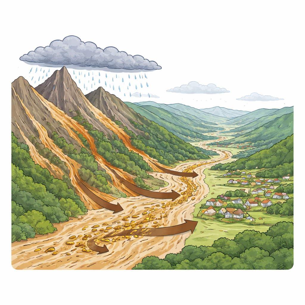
In many of the world’s mountain regions, especially in southwestern China, deadly floods can roar down narrow valleys with little warning. These flash floods are not just walls of water: they often carry huge amounts of mud, rocks, and debris that smash homes, bury roads, and reshape river channels. This study asks a simple but vital question: can we spot the places most likely to suffer these violent water-and-mud surges before disaster strikes, and do it in a way that matches what really happens on the ground?
When water meets loose earth
The authors focus on Aba Prefecture, a rugged region where high peaks give way to deep valleys cut by fast rivers. Heavy rain is common, earthquakes have shattered many slopes, and vast stores of loose rock and soil sit poised above rivers. Past national maps of flash flood danger in China mainly highlighted where intense rain can produce fast runoff. Yet the researchers show that almost half of recorded flash floods actually happened in places that were officially ranked as “low risk” or outside mapped danger zones. A major reason: most maps paid little attention to the extra punch delivered when loose sediment is swept into the flood and turns it into a churning, debris-rich flow.
Teaching computers to read the landscape
To improve predictions, the team built a data-driven method that blends classic terrain and weather information with a detailed picture of where loose material is stored. They fed a computer model with maps of slope, curvature, rock type, distance to rivers and faults, soil erodibility, vegetation cover, rainfall, land use, and—crucially—the frequency of past landslides and unstable slopes. Using a two-step approach, they first gauged how strongly each factor, and each range of its values, lined up with known flash flood events. Then they used an ensemble learning technique, a form of machine learning that combines many simple decision rules, to classify the susceptibility of more than 5,000 small watersheds across Aba Prefecture.
Sharper maps of danger spots
The new maps reveal that the highest flash flood danger is concentrated in the eastern and central–southern parts of Aba, plus a few zones in the northwest, often tracing major fault lines where steep slopes and loose deposits are common. Compared with the widely used national Flash Flood Investigation and Assessment (FFIA) results, the new method assigns a much larger share of past disasters to areas labeled as “high susceptibility” and fewer to “very low susceptibility.” In practice, this means the refined maps do a better job of matching where flash floods have actually occurred. The improvement stems from explicitly including sediment source areas, so the model does not just find places where water can collect quickly but also those where that water can mobilize large amounts of rock and soil.
Zooming in on a hard-hit river basin
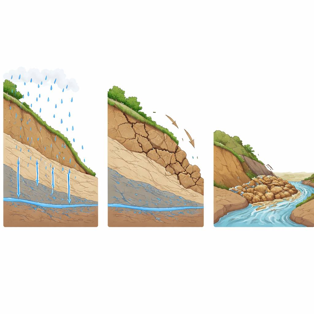
To see how this plays out during a real storm, the researchers zoomed in on the Shouxi River basin, where a severe rain event on August 19–20, 2019 triggered widespread damage. They divided the basin into thousands of slope units and used a physics-based model to simulate how rainwater soaks into hillsides, raises pore water pressures, and weakens slopes. This allowed them to pinpoint patches where the safety margin against sliding dropped below a critical value. They then estimated how much material could move in potential landslides by combining the area of these risky slopes with a known relationship between landslide area and volume derived from earlier earthquakes and field surveys.
How much mud a single storm can move
The analysis showed that during the 2019 storm, about 8.4% of the Shouxi basin’s area consisted of high-risk slopes, mostly in its upper and middle reaches. If those unstable areas failed and fed material into the river, they could supply on the order of ten million cubic meters of sediment to a single flood event. When such a volume of loose debris is set in motion by fast-moving water, the result is far more destructive than a flood of clear water alone, explaining the severe channel changes and damage observed in the basin.
What this means for people living downstream
For residents of mountain valleys and for planners charged with protecting them, the study’s message is clear: mapping flash flood danger must consider not only where rain falls and water runs, but also where the hillsides are loaded with loose earth ready to be swept away. By tying together large-scale machine learning maps with more detailed physical models of slope failure, the authors offer a way to flag both broad danger zones and specific source areas that feed mud-rich floods. Although the method still depends on good data and needs testing in other regions, it points toward more realistic early-warning systems that can better anticipate the most devastating flash flood disasters.
Citation: Liu, H., Wang, Y., Xu, C. et al. Potential recognition of flash flood disasters in China’s southwestern mountainous areas considering source supply conditions. npj Nat. Hazards 3, 36 (2026). https://doi.org/10.1038/s44304-026-00183-x
Keywords: flash floods, mountain hazards, landslides, sediment transport, disaster mapping