Clear Sky Science · en
Projections of tropical cyclone-driven storm-tide risk to critical infrastructure in the Bay of Bengal
Why this matters for coastal life and safety
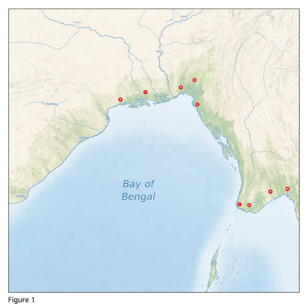
The Bay of Bengal, bordered by India and Bangladesh, is home to tens of millions of people, major cities, and vital facilities like power plants and ports. It is also one of the most dangerous places on Earth for cyclone‑driven coastal flooding. This study asks a pressing question: as the climate changes and seas rise, how high could storm‑driven waters reach at critical sites, and how often might those extremes occur over the coming centuries?
Storms, tides, rivers, and rising seas
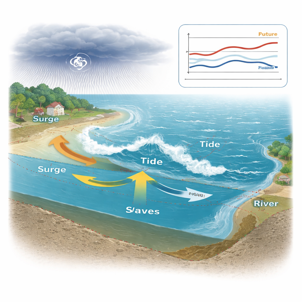
Coastal flooding here is not caused by one factor alone. Tropical cyclones push the sea inland as storm surge, tides raise and lower the background water level, waves run up beaches and sea walls, and huge rivers pour freshwater into the delta. On top of that, global sea level is rising and parts of the delta are slowly sinking. The authors build a detailed computer model of the Bay of Bengal that combines all of these influences at once. They then drive this model with thousands of synthetic cyclones representing a thousand years of weather under both today’s climate and several mid‑century climate projections, sampling different tidal stages and river flows for each storm.
Following thousands of virtual cyclones
Instead of relying only on a short historical record, the team uses a synthetic storm dataset that mimics the statistics of real cyclones but extends them over millennia. For each storm, they run 12 versions in the model, changing whether it arrives at high tide, low tide, or during fast‑moving tidal currents, and pairing it with low, average, or high river discharge. For future scenarios, they also raise the mean sea level at the open boundary according to climate model projections. This large virtual catalogue allows them to estimate how often very rare events—floods expected once every 1,000 or even 5,000 years—might occur at selected sites, including existing and proposed nuclear power stations and key locations in the Ganges–Brahmaputra–Meghna delta.
Untangling complex water level drivers
To understand which processes matter most, the authors compare full model results with simpler "add‑them‑up" estimates that linearly combine separate simulations of tides, surge, river flow, and mean sea level. By examining how much these linear estimates differ from the full physics‑based simulations, they can see where interactions are crucial. They find that wave runup and the way surge interacts with tides and with raised mean sea level significantly alter the peak water levels. In several locations, simply adding the pieces underestimates extreme flood heights by up to about 25 percent, while adding waves alone without other interactions can overshoot by as much as 35 percent. This means that engineering designs based on oversimplified methods could seriously misjudge true risk.
Where risks rise and where they fall
The study’s most striking result is that climate change does not affect the whole region in the same way. In the low‑lying delta of Bangladesh and eastern India, the modeled long‑term flood levels driven by cyclones generally decrease by around 30 percent by mid‑century, even though they remain very high—on the order of 5 to 6.5 meters for 1,000‑ to 5,000‑year events. This decrease is linked to shifts in where storms form and how they travel, with fewer powerful landfalls in the delta. In contrast, along India’s eastern seaboard, including near Chennai and the site of the proposed Kovvada nuclear power project, extreme storm‑tide levels increase. At Kovvada, a flood expected once every 5,000 years could be up to 78 percent higher than under today’s climate, driven by stronger wave effects and less damping from tide‑surge interactions.
Implications for future planning
For non‑specialists, the takeaway is clear: coastal flood risk is shaped by the combined push of storms, tides, waves, rivers, and rising seas, and these elements do not simply add together. High‑resolution regional models that capture their interactions are essential for setting safe elevations and defenses around critical infrastructure. This study suggests that some parts of the Bay of Bengal delta may face slightly lower cyclone‑driven water levels in coming decades, though still dangerous, while eastern India’s coast may become more exposed. Planners and engineers cannot assume uniform changes along the shoreline; they need site‑specific assessments that look centuries ahead to ensure that power plants, cities, and transport links remain secure in a changing climate.
Citation: Blakely, C.P., Pringle, W.J. & Kotamarthi, V.R. Projections of tropical cyclone-driven storm-tide risk to critical infrastructure in the Bay of Bengal. npj Nat. Hazards 3, 22 (2026). https://doi.org/10.1038/s44304-026-00175-x
Keywords: Bay of Bengal, storm surge, tropical cyclones, coastal flooding, critical infrastructure