Clear Sky Science · en
Glacial lakes and GLOFs in a warming Himalaya-Karakoram region: current understanding, challenges, and the way forward
Melting Mountains, Rising Risks
The Himalaya and Karakoram mountains are often called Asia’s “water towers,” feeding great rivers that support more than a billion people. As the climate warms, their glaciers are shrinking and thousands of new high‑altitude lakes are forming. Beautiful but dangerous, some of these lakes can suddenly burst, sending walls of water and debris racing down narrow valleys. This review pulls together what scientists now know about these glacial lakes, the floods they unleash, and how communities can prepare for a more unstable future in the world’s highest mountains.
New Lakes in a Warming High Asia
Over the past few decades, the Himalaya–Karakoram region has warmed faster than the global average, with temperatures in many high areas rising by several tenths of a degree Celsius per decade. Warmer air and shifting snowfall patterns are driving glaciers to thin and retreat. Where ice once filled valleys, meltwater now pools to form glacial lakes, often held back only by loose rock and ice rubble. Since 1990, the number, area, and volume of glacial lakes worldwide have grown by roughly half, and under high‑emission futures as much as 65% of the ice in High Mountain Asia could vanish by 2100, creating even more—and larger—lakes.
Where the Danger Is Greatest
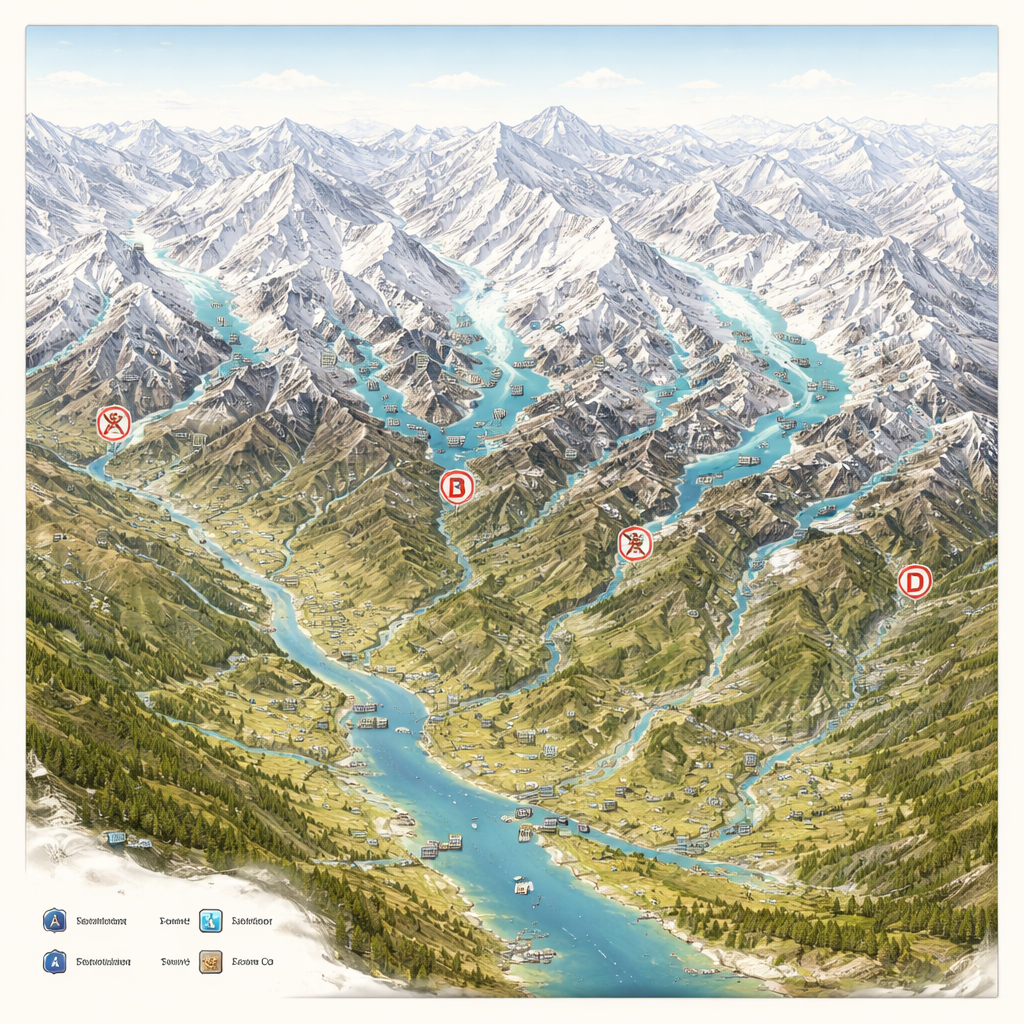
Using satellite images and existing databases, the authors map the spread of glacial lakes across the Himalaya–Karakoram arc and tally past glacial lake outburst floods, or GLOFs. They identify more than 19,000 glaciers and tens of thousands of lakes, with the Central and Eastern Himalayas holding the largest lake areas. Yet the Karakoram, which has relatively fewer mapped lakes, has recorded the most outburst floods because many lakes there are repeatedly dammed and re‑dammed by moving glacier ice. Overall, at least 388 GLOF events have been documented in the region, mostly from lakes dammed by ice or loose moraine. These floods tend to strike during the hot, often rainy months of June to August, when melting and storms are at their peak.
How Glacial Lakes Fail
The paper explains that lakes do not burst simply because they exist; they need a trigger. Unstable natural dams made of ice or rock are especially vulnerable. An intense rainstorm, a rapid heat wave, an ice or rock avalanche crashing into the lake, or hidden melting inside the dam can all raise water pressure or send waves over the dam crest. Once water finds a path through or under the dam, it can rapidly carve a tunnel, releasing a rushing torrent that scours the valley below. Many triggers likely go unobserved in remote terrain, but evidence points to extreme weather and ice or rockfalls as the most common culprits, with earthquakes so far playing a smaller role than often feared.
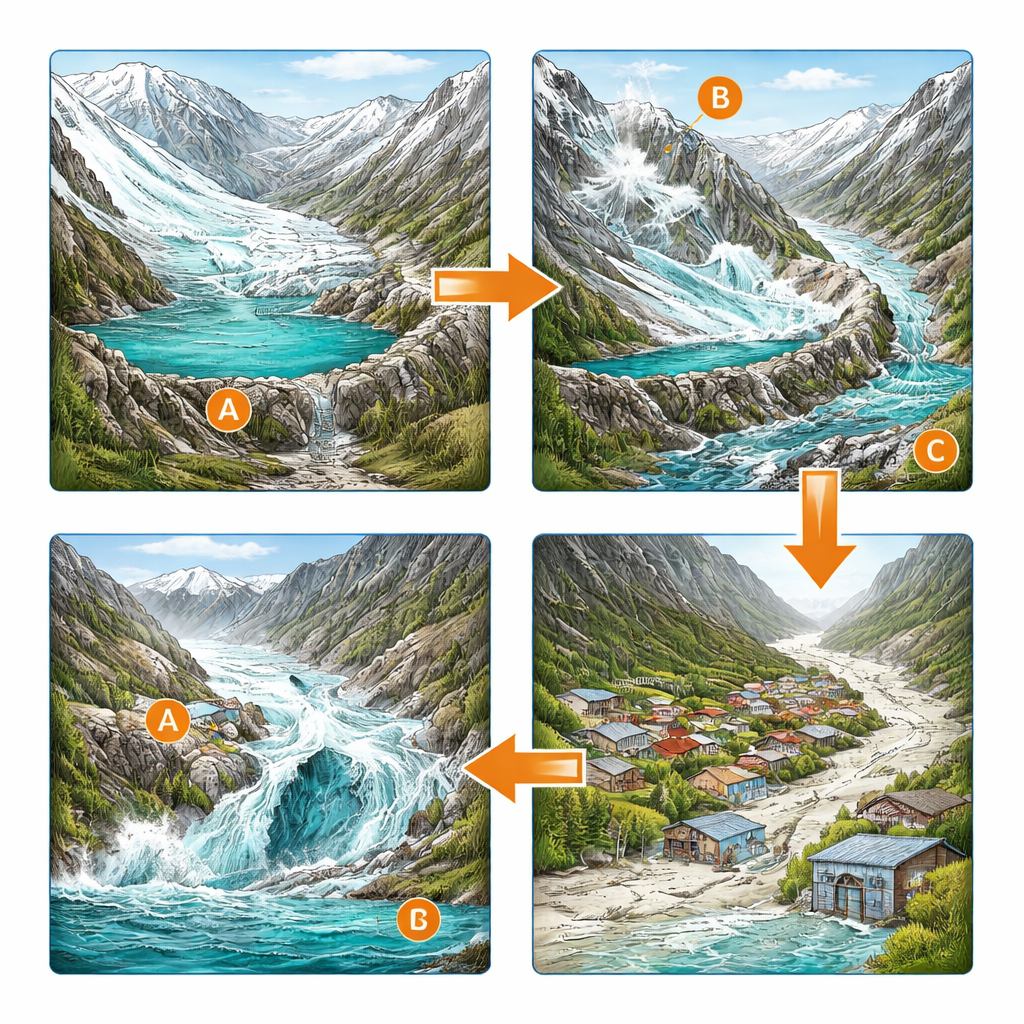
Communities in the Flood Path
The stakes are high: around one million people live within just 10 kilometers of a glacial lake in this region, alongside roads, bridges, and hydropower plants built close to mountain rivers. The review shows that research on glacial lakes has expanded rapidly, from basic mapping to detailed risk studies and computer models of possible flood paths. Scientists have identified “potentially dangerous glacial lakes,” reconstructed past disasters, and projected thousands of new lakes by century’s end. Yet big gaps remain. Inventories are not fully consistent, many lakes lack on‑the‑ground measurements, and social factors—who is exposed, who is vulnerable, and how people perceive risk—are often understudied.
Preparing for Future Floods
To reduce risk, the authors highlight a toolkit that ranges from engineering works to local training. Early warning systems combine satellite monitoring, weather stations, lake‑level sensors, and phone networks to alert villagers when danger looms. Structural measures such as spillways, controlled drainage, siphons, or dam reinforcement can safely lower a lake’s level, though they are costly and technically demanding for many mountain countries. Equally important are non‑structural steps: educating residents, planning evacuation routes, running drills, and weaving GLOF risk into land‑use rules and infrastructure design. Because rivers and hazards cross borders, the paper argues that regional cooperation and shared data—much of it coordinated by the International Centre for Integrated Mountain Development—are essential.
What It Means for People Downstream
In simple terms, the study concludes that climate change is loading the dice for more dangerous floods in the Himalaya–Karakoram. As glaciers waste away, glacial lakes are multiplying and growing, while more people and investments crowd into the valleys below. Outburst floods will remain relatively rare, but when they occur they can be devastating. The authors argue that science, engineering, and community action must come together: better lake maps and monitoring, smarter planning to keep critical assets out of harm’s way, and practical, locally led preparedness. With such measures, mountain societies can live more safely with their changing high‑altitude waters—even as the ice above them continues to retreat.
Citation: Rather, A.F., Ahmed, R., Shamim, T. et al. Glacial lakes and GLOFs in a warming Himalaya-Karakoram region: current understanding, challenges, and the way forward. npj Nat. Hazards 3, 7 (2026). https://doi.org/10.1038/s44304-026-00168-w
Keywords: glacial lake outburst floods, Himalaya Karakoram, climate change, mountain hazards, disaster risk reduction